Kecamatan Tulangan, Indonesia
30 memories from Kecamatan Tulangan, Indonesia

The video shows the interior of a home in Indonesia, with several people present. Some are standing in a hallway, while others are seated in the living room. Most of the women are wearing hijabs, and some of the men are wearing traditional Muslim caps. A woman in a pink patterned dress is handing money to a boy who is sitting on a woman's lap. There is furniture and other household items visible in the background. The walls are painted yellow. The atmosphere appears to be somewhat formal or celebratory.
Kecamatan Tulangan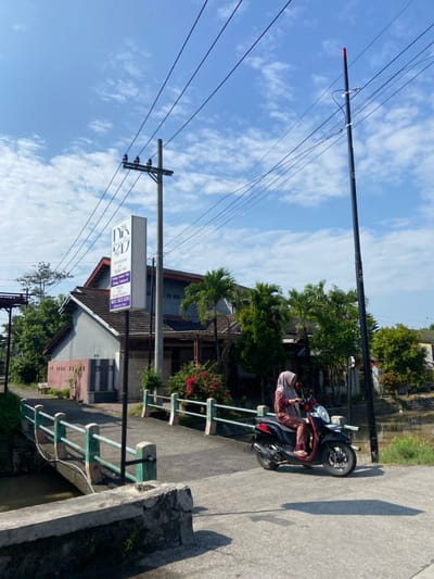
The image depicts a woman wearing a hijab riding a red and black scooter across a small concrete bridge. The bridge is flanked by a metal railing and sits over a narrow canal. The woman is traveling from left to right in the image. On the left side of the image, there is a sign advertising a business named "Dr. Liza Aesthetic Clinic". The sign is mounted on a black pole which is also supporting several electric wires running across the sky. On the left, a grey concrete building with a maroon-colored trim is partially visible. The building is set back from the street and covered in green foliage. The sky is a clear blue with white clouds, and the day is sunny. The location is Kecamatan Tulangan, Indonesia (latitude: -7.476, longitude: 112.616).
Kecamatan Tulangan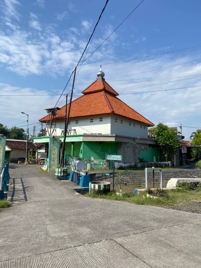
The scene is a street corner in Kecamatan Tulangan, Indonesia, located at latitude: -7.475, longitude: 112.616. A small mosque, with an orange tiled roof and white walls, is visible on the right side of the street. The mosque is located behind a low stone wall, with a green painted fence. On the left side of the street is a concrete bridge, with a metal gate. There is a sign indicating the street name, "JL. LAKSANA." There is a small metal pole on the left side of the bridge, with a sign, "RW. 02," visible on the side. The street is paved with concrete and there are power lines running overhead. The sky is blue with white clouds, and there are trees and shrubs visible in the background. There is a small, shallow stream on the other side of the wall from the mosque. There are no people present.
Kecamatan Tulangan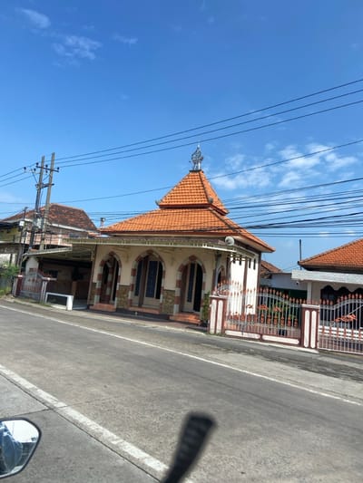
The image shows a small mosque with an orange roof, located on a paved road in the village of Tulangan, Sidoarjo, Indonesia. The mosque is built in a traditional style with arched windows and a decorative gate. The mosque is surrounded by houses and lush greenery. The sky is clear and blue. It is a sunny day, and there are no people present in the image. The mosque is located on the left side of the road, with a white painted line marking the edge of the road. There are several power lines running across the sky. The mosque has an ornately decorated roof. There is a second, smaller house to the right of the mosque, with a similar style to the mosque, also featuring a red tile roof. The road is paved with grey asphalt and is empty except for a motorcycle in the foreground. There are tall palm trees and green vegetation in the background. The mosque is visible from the road and is a prominent landmark in the area.
Kecamatan Tulangan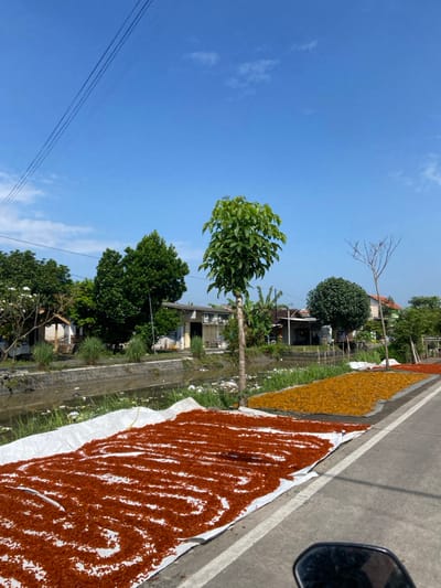
The image shows a street scene in Kecamatan Tulangan, Indonesia. The location is identified by coordinates -7.474 latitude and 112.621 longitude. The scene is dominated by a large expanse of dried red chili peppers laid out on white sheets in parallel lines, creating a striking contrast against the paved road. The chili peppers are spread out on the edge of the road, beside a small drainage canal, and are likely being sun-dried for preservation. In the background, a cluster of buildings are visible, including residential structures, one with a corrugated metal roof, and a small, open-air shop with its awning raised. There are lush, green trees lining the street, including a large tree with a broad canopy in the center of the scene. The sky is a clear, bright blue with a few small white clouds. The scene appears to be taken from the vantage point of someone standing on the road, looking toward the canal.
Kecamatan Tulangan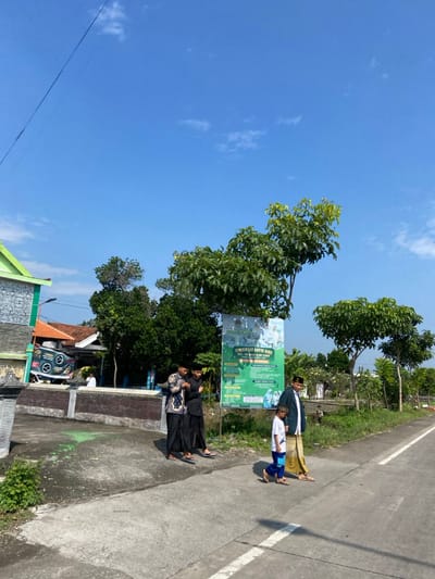
The scene is a street in Kecamatan Tulangan, Indonesia, located at coordinates -7.474 latitude and 112.621 longitude. Four men, all wearing long-sleeved shirts and pants, are walking on the street. One man is wearing a black headscarf and white long-sleeved shirt. Another is wearing a white headscarf and black long-sleeved shirt. The other two men are wearing white head coverings. A small boy with short hair, wearing a blue shirt and shorts, is also walking on the street. The men are walking on a paved street with a white line down the center. To the left of the street is a low brick wall. Behind the wall is a green house with a green roof. There is a large, green sign to the right of the men, advertising "JUM'AT BARU" (New Friday) with information about religious events. Behind the sign are large trees with green leaves. The sky is blue and mostly cloudless. The men are walking in the same direction on the paved road.
Kecamatan Tulangan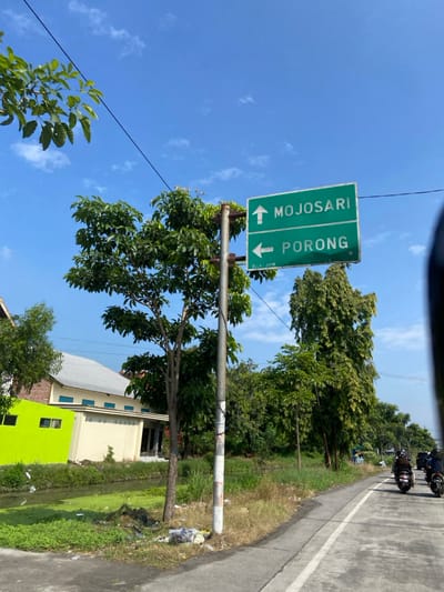
The image shows a road sign in Kecamatan Tulangan, Indonesia, located at coordinates -7.475 latitude and 112.634 longitude. The sign indicates two directions: "Mojosari" to the right, and "Porong" to the left. The sign is mounted on a metal pole, and the background consists of a paved road, green grass, a small canal, and lush greenery. The road is straight and runs horizontally across the image. A small, single-story building is located behind the sign, with a bright green wall. Three motorbikes are driving on the paved road in the distance, heading towards the right. The sky is blue with white clouds. The trees in the background are all green.
Kecamatan Tulangan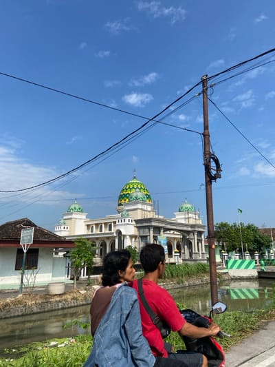
The image shows a scene in Kecamatan Tulangan, Indonesia (latitude: -7.475, longitude: 112.634). A man and a woman are sitting on a red moped. The man is wearing a red shirt and black shorts. The woman is wearing a blue jacket over a green shirt. They are both looking to the right. Behind them is a mosque with a green and yellow dome. The mosque is surrounded by a canal. The sky is blue with some clouds. There are power lines running across the sky. There are lush green plants around the canal and a small green sign in the foreground.
Kecamatan Tulangan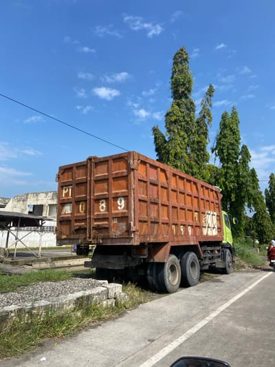
A large, rusty dump truck is parked on the side of a paved road in Kecamatan Tulangan, Indonesia, at coordinates -7.477 latitude and 112.639 longitude. The truck is facing the right, with its bed tilted up. The truck is partially obscured by a row of bushes on the right side of the image, and tall, green trees on the left. The truck has a white, painted number "PT 089" on its side. It appears to have recently been used, with dust and dirt on the sides. The road is lined with a white strip on the right side of the image, and there are a couple of large concrete blocks by the truck. To the left of the truck, a row of bushes and a wall and gate can be seen in the distance. The sky is blue, with a few white clouds. There is another, smaller vehicle driving away from the truck on the road in the distance. The truck's back tires are touching the road. The truck's front wheels are visible, but appear to be off the road.
Kecamatan Tulangan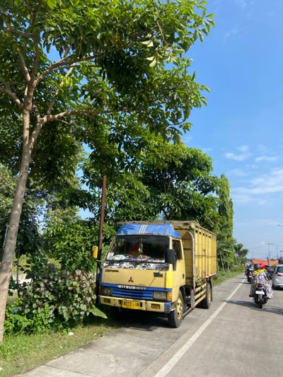
A yellow and blue Mitsubishi truck is parked on the side of a paved road in a suburban area of Kecamatan Tulangan, Indonesia. The truck is facing the right side of the image, and is partially obscured by a large, leafy tree on the left. The truck has a flatbed with sideboards and is loaded with unknown cargo. There is a white line painted down the center of the road. A single motorcycle is visible on the right side of the road, moving in the direction the truck is facing. The sky is a clear blue, with scattered white clouds.
Kecamatan Tulangan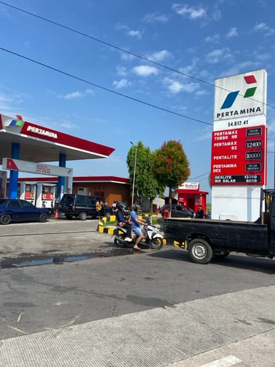
The image shows a gas station in Kecamatan Tulangan, Indonesia, located at the coordinates -7.479 latitude and 112.643 longitude. There are several cars and motorcycles parked on the asphalt lot. Two individuals wearing helmets are riding a white moped on the left side of the image, while a black pickup truck is parked on the right side. The gas station is a Pertamina brand, and the sign displays the prices for different types of fuel, including Pertamax Turbo 98, Pertamax 92, Pertalite, Pertamina Dex, and Dexlite Bio Solar. The sky is blue with white clouds and there are trees surrounding the lot.
Kecamatan Tulangan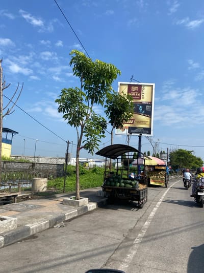
The image shows a street in Kecamatan Tulangan, Indonesia (latitude: -7.48, longitude: 112.644). A large billboard with a cigarette advertisement stands on the right side of the road, partially obscured by a large tree. A vendor is parked on the side of the road, selling watermelons from a small truck. Several motorbikes are parked and driving on the road in the distance. The sidewalk is lined with trees and bushes. The sky is blue and clear, with a few white clouds.
Kecamatan Tulangan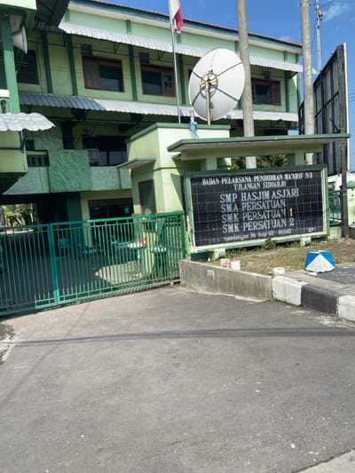
The scene is a school entrance in Kecamatan Tulangan, Indonesia. The school is a two-story building with a green facade and a satellite dish on the roof. The entrance to the school is through a green metal gate. There is a sign on the right side of the gate that reads "BADAN PELAKSANA PENDIDIKAN MA'ARIF NU TULANGAN SIDOARJO SMP HASJIM ASJARI SMA PERSATUAN 1 SMK PERSATUAN 2". There are also several paint cans on the ground next to the sign. The ground is paved with asphalt. The sky is blue with white clouds. The location is approximately -7.48 latitude, 112.644 longitude.
Kecamatan Tulangan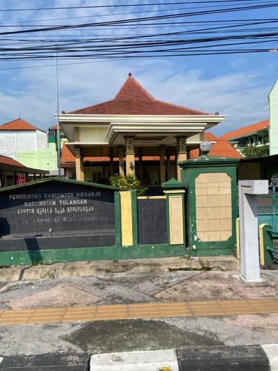
The image shows the exterior of the building for the Kecamatan Tulangan, located at latitude -7.48 and longitude 112.645 in the city of Kecamatan Tulangan, Indonesia. The building has a red roof with a white, ornate trim and white columns. The building is surrounded by a green brick wall with a plaque on the front that says, "PEMERINTAH KABUPATEN SIDOARJO KECAMATAN TULANGAN KANTOR KEPALA DESA KEPADANGAN". The building is situated in a residential area with other buildings visible in the background. There are many power lines in the sky above the building. The ground is concrete with a cracked sidewalk in front of the building. There is a large, white, concrete pillar on the right side of the image.
Kecamatan Tulangan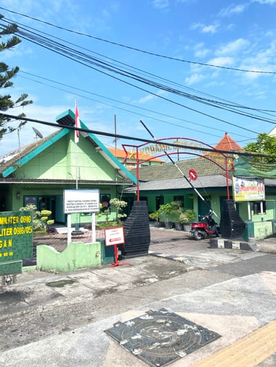
The image shows the entrance to a military building in Kecamatan Tulangan, Indonesia, located at latitude -7.481 and longitude 112.645. A red and white Indonesian flag hangs from a pole on a green building to the left of the entrance. The entrance is marked by a red and gold arch with the words "KORAMIL 0816/05 TULANGAN" inscribed on it. The arch is flanked by two black pillars, one of which is topped with a red stop sign. A red and white sign on the right side of the entrance reads "POMDAM V/BRW" with a black and white sign below it that is not legible in the photo. There is a small, red, wheeled scooter parked to the right of the entrance. The entrance is paved with gray concrete, which extends outwards in a slight downward slope. There are several green plants and trees surrounding the building. The sky is blue with white clouds. The building has a green painted facade and a brown roof. A sign on the left side of the building is visible with the text "PERSIT KARTINI CABANG KRAMAT RANTING 5 KORAMIL 0816/05 TULANGAN KOMANDO KEHIDUPAN NO. 31 TULANGAN".
Kecamatan Tulangan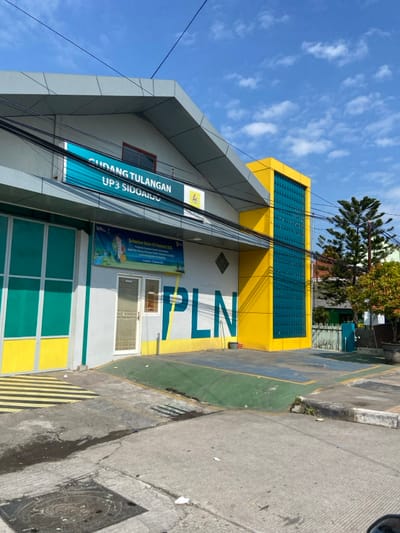
The image shows a building located in the city of Kecamatan Tulangan, Indonesia, with coordinates -7.481, 112.645. The building is a single-story, and is painted with yellow and turquoise. It has a sign that reads "Gudang Tulangan UP3 Sidoarjo". There is a large, white "PLN" painted on the side of the building. The building has a large, open doorway leading to the interior. The door is a glass and metal door, framed in white, and has a few small, black trash cans and a planter in front of it. The ground in front of the building is paved with a gray concrete. The building is located on a street with a few small trees and some vegetation in the background. The sky is blue with white clouds.
Kecamatan Tulangan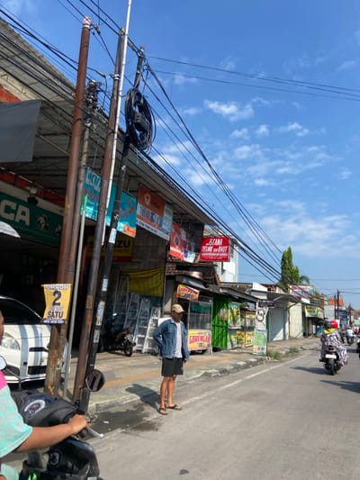
The image shows a street scene in Kecamatan Tulangan, Indonesia (latitude: -7.481, longitude: 112.646). The street is lined with shops and businesses. There are many power lines overhead. A man in a blue denim jacket and black shorts is standing on the sidewalk, facing the street. He is looking to his left. He is standing in front of a shop with a sign that reads "GORENGAN". A motorcycle is parked on the sidewalk to his left, and a car is parked to his right. There is a motorcycle in the street, which is empty. The sky is bright blue with a few clouds.
Kecamatan Tulangan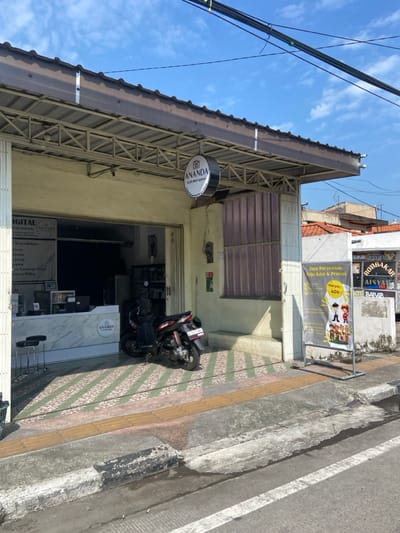
The image shows the exterior of a storefront in Kecamatan Tulangan, Indonesia, located at latitude: -7.482, longitude: 112.647. The storefront is a single-story building with a brown awning and a sign that reads "ANANDA" in white lettering. The awning is supported by a metal frame. There is a large window on the right side of the storefront, which is covered with a white plastic sheet. The front of the storefront is paved with a black and white checkered tile pattern. A black motorcycle is parked in front of the storefront, near a step leading up to the entrance. There is a black metal stool to the left of the entrance, along with a marble counter and a small sign that reads "ANANDA". A sign for a clothing store advertising a 40% sale is located on the right side of the storefront. The building next door is visible behind the sign, with a sign in Indonesian reading "ROTI BAKAR Aisyah" in white lettering. The street in front of the storefront is paved with asphalt and a white stripe is visible on the right side of the image. The sky above the street is blue and partly cloudy.
Kecamatan Tulangan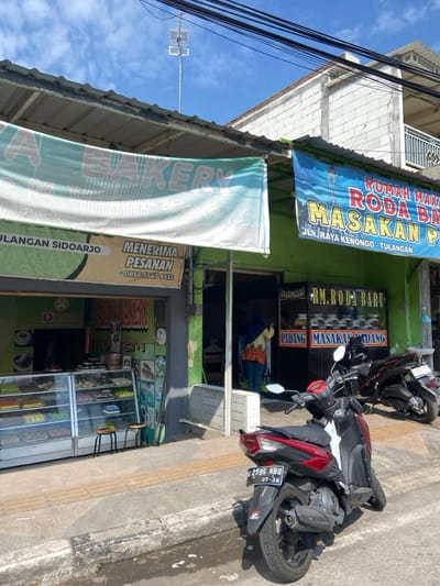
The scene is a street in Tulangan, Indonesia, with a bakery on the left side and a restaurant on the right. The bakery is called "A Bakery" and has a green awning and a large window display filled with pastries. The restaurant is called "Rumah Makan Roda Baru" and is decorated with a bright blue sign with red lettering. The restaurant has a sign on the door that reads "RM. Roda Baru" and another sign that reads "Padang Masakan Padang" in a more rustic style. A woman stands in front of the restaurant in front of a dark door, wearing a white and green striped shirt with a yellow cardigan and brown pants. She is standing near a table with a yellow and red tablecloth. There is a black motorcycle parked in front of the restaurant. There is a second black motorcycle parked on the sidewalk, partially obscured by a sign that reads "Padang Masakan Padang". The motorcycles are both modern models with bright headlights and red accents. The scene is bright and sunny. The sidewalk in front of the businesses has a light brown, textured concrete surface, and the street is asphalt. The scene is framed by a white, brick building in the background, partially obscured by a blue sky and white clouds. There are several electrical wires running along the top of the buildings. There is a tall antenna on top of the brick building. The ground and sidewalk are dry and there is no evidence of rain. The scene appears to be captured on a relatively clear day. The coordinates provided are -7.482 latitude and 112.648 longitude.
Kecamatan Tulangan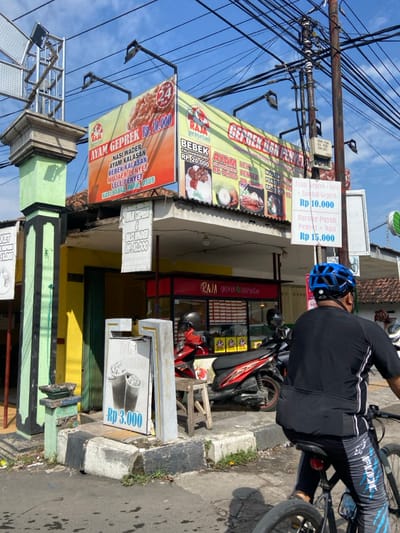
A man wearing a black shirt and blue and black cycling pants stands in front of a food stall in Kecamatan Tulangan, Indonesia (latitude: -7.482, longitude: 112.648). The stall has a red awning and several signs, one that reads "Ayam Geprek Rp 10,000" and another that reads "Bebek Kalasan Rp 20,000," suggesting that the stall sells fried chicken and duck. The man is looking at the camera. He has a bicycle parked next to him and there are several other bicycles in the background. The street is paved and there are power lines overhead. The weather is sunny and the sky is blue. The image is taken at a low angle.
Kecamatan Tulangan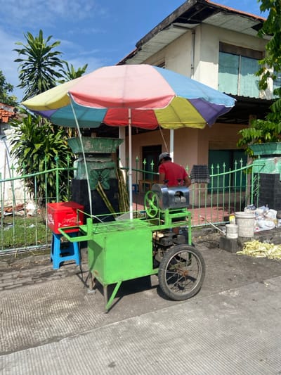
A man wearing a red shirt and a baseball cap is standing next to a green cart with a red cooler next to it. He is standing in front of the cart, facing away from the camera. There is a large, multi-colored umbrella above the cart and man. The cart appears to be a street vendor cart with a large, metal drum-like object attached to the cart. The street vendor cart appears to be selling sugar cane juice. There is a metal fence behind the cart, and a concrete building to the right of the fence. The scene is located in Kecamatan Tulangan, Indonesia. The coordinates are -7.482 latitude, 112.648 longitude.
Kecamatan Tulangan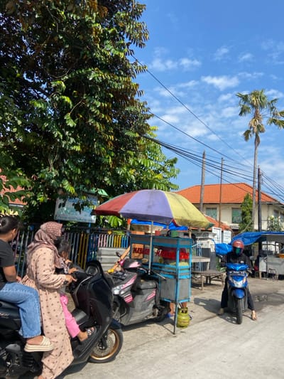
The image shows a street scene in Kecamatan Tulangan, Indonesia, located at coordinates -7.482 latitude, 112.648 longitude. A woman in a brown dress is seated on a black motorcycle, with a young girl standing behind her on the motorcycle's footrest. Both are looking to their right at an unidentified person off-camera. The woman is wearing a headscarf. Another woman is seated on a second motorcycle behind the first motorcycle and is looking towards the camera. A man is on a blue motorcycle parked to the right of the image. He is wearing a black helmet and a blue and white jacket. In the background, there are two buildings, one with a red roof and the other with a green roof. A colorful umbrella with a stand is located in the middle of the image, next to a street food cart. Several power lines are visible overhead. The image suggests a normal day in a small village, with people going about their daily business.
Kecamatan Tulangan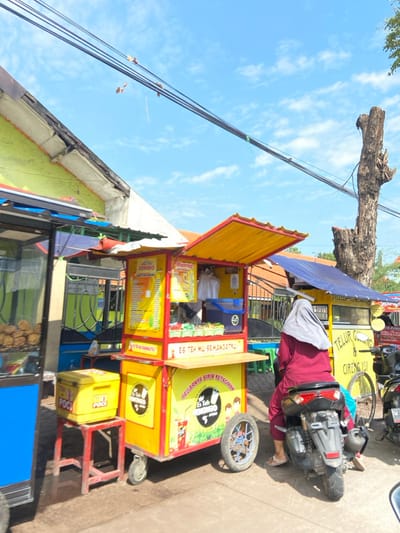
The image shows a street food vendor in Kecamatan Tulangan, Indonesia, a small town located at approximately -7.482 latitude and 112.649 longitude. The vendor is selling iced tea and snacks from a yellow and red cart. The cart is adorned with various Indonesian language signs, including "Es Teh Mu Semaangatku" (Your Iced Tea, Makes You Enthusiastic) and "Segarsnya Bikin Ketagihan" (It's Refreshing, It Makes You Crave More). To the right of the cart is a person seated on a motorcycle, wearing a gray hijab and a maroon long-sleeved shirt, with a blue bag hanging from their left wrist. They are positioned to the right of the cart, near a blue and white, blue and yellow, and a yellow food cart, all equipped with canopies. Behind the carts are two buildings, one with a partially visible bright green wall, and another featuring a yellow roof. The scene is set on a paved road, with electrical wires overhead, and a clear sky with light clouds in the background. A tree is visible in the background, its branches reaching towards the sky.
Kecamatan Tulangan
The image shows a street scene in the Kecamatan Tulangan area of Indonesia, located at coordinates -7.483, 112.65. A two-story building with a green and pink facade stands on the left side of the street. The building has a distinctive feature: two domed structures on the roof, painted in a yellow and blue pattern. A sign on the building reads "PPDSB", likely referring to a local educational institution. The street is paved and empty, with a few power lines running overhead. A black metal fence separates the sidewalk from the street. A green bush, and a few smaller plants grow along the front of the building. A signpost with the inscription "PAUD SABITUL AZMI" stands on the right side of the fence. A "children crossing" sign is visible in the background. The sky is blue with white clouds.
Kecamatan Tulangan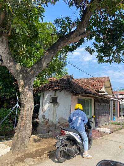
The image shows a young man in a blue denim jacket and a yellow helmet sitting on a black motorcycle. The motorcycle is parked on the dirt side of a paved road. The man is looking to the right of the image. The motorcycle has a license plate number of "N 7730 BC". The man is sitting on the seat of the motorcycle with his right foot on the ground. He is about to pull off on the road. There is a small, two-story house to the left of the motorcycle. The house is made of white stucco with a red tile roof. There is a single window in the lower part of the house. The man is standing in front of a large tree that is casting shade over the scene. The scene is likely in Tulangan, Indonesia, which is located at latitude -7.483 and longitude 112.65.
Kecamatan Tulangan
The scene is set in front of a small workshop on the outskirts of a residential area in Kecamatan Tulangan, Indonesia. A large tree trunk dominates the left side of the scene, while a pole with a yellow flag hangs from the top, positioned next to the workshop. The workshop is a simple structure with a corrugated metal roof and a brick wall. A sign on the workshop reads "SUKA SENYAP 36" and "AREK AREK DEWI" (spelling and grammar may not be perfect). A man in a red shirt sits on a motorcycle, while another man in a black helmet looks on from the back of another motorcycle. A white car is parked in the street. The ground is covered in dirt and debris. The sky is blue and cloudless.
Kecamatan Tulangan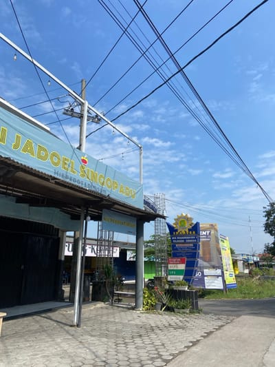
The image shows a street corner in Kecamatan Tulangan, Indonesia (latitude: -7.484, longitude: 112.652). There is a blue and yellow sign for a restaurant called "Jadoel Singop ABU" which is a Mie Pedos & Pinsur shop. To the right is a sign for a school, SMAN 1 TULANGAN, with the words "SMA NEGERI 1 TULANGAN - SURABAYA - JAWA TIMUR" printed on it. There are a few small trees and shrubs in the foreground. The ground is paved with concrete blocks. The sky is blue and sunny. There are power lines running across the street, creating a network of black wires against the bright sky.
Kecamatan Tulangan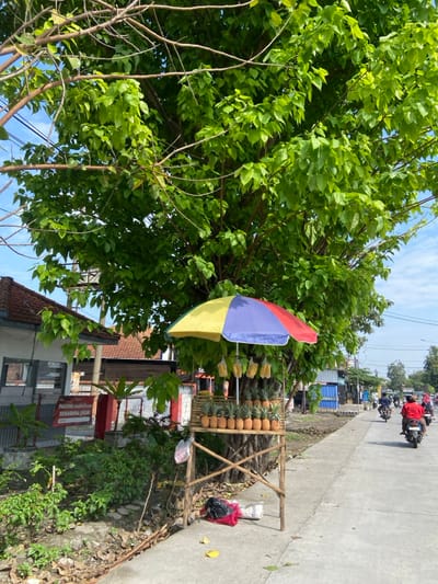
The scene is a street side fruit stand located in Kecamatan Tulangan, Indonesia, at the coordinates -7.485 latitude and 112.652 longitude. A large, leafy tree stands over a stand, which has a colorful umbrella and a wooden structure with a variety of pineapples stacked on shelves. The stand is located on a paved street with a sidewalk on the left side. There are houses in the background and a few people are riding motorcycles in the distance. The road is largely empty.
Kecamatan Tulangan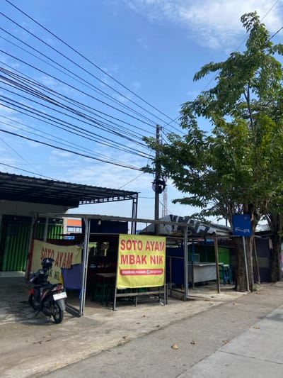
The scene is a street in Kecamatan Tulangan, Indonesia, located at latitude -7.487, longitude 112.654. A large tree with green leaves stands on the right side of the image, casting shade on a food stall to the left. The stall is covered by a yellow awning and has a sign that reads "Soto Ayam Mbak Nik". The stall is empty, with a couple of chairs and a table on the left. A motorcycle is parked in front of the stall. In the background there are several other buildings and stalls, all of which are enclosed by walls. The street is paved with concrete and there are some fallen leaves scattered on the ground. The sky is blue and there are some clouds in the distance. Numerous power lines run overhead, connected to a tall utility pole. There is a tall red and white radio tower in the background. There are no people in the image. The image is taken from a street level angle.
Kecamatan Tulangan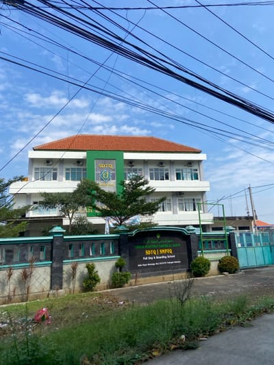
The image shows a two-story school building, identified as "SDTQ | SMPTQ Full Day & Boarding School", located at Jalan Raya Kemanggisan No.21 in Tulangan, Sidoarjo, Indonesia, with coordinates of -7.487 latitude and 112.654 longitude. The building is white with a red tile roof and green accents. It is surrounded by a black and green fence. A small, green tree grows in front of the building. The building's facade is visible, with windows and an entrance. The school's sign is prominent and displays the school's name, address, and information about being a full-day and boarding school. There are many power lines running across the sky, and the sky is a clear blue with a few white clouds.
Kecamatan Tulangan