Tayba Alhasanab, Sudan
9 memories from Tayba Alhasanab, Sudan
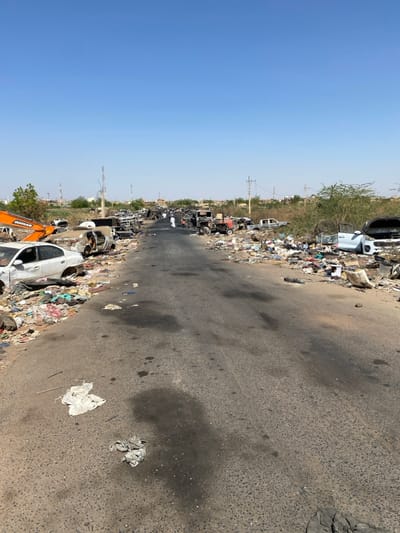
The image shows a street in Tayba Alhasanab, Sudan, located at latitude 15.36 and longitude 32.528. The street is littered with debris, including burned-out vehicles and scattered trash. There are two people in the distance, walking away from the camera. The street is paved and runs straight ahead, with a grassy median separating the two sides. The sky is clear and blue, with no clouds visible. There are power lines visible overhead. The scene is indicative of destruction and abandonment.
Tayba Alhasanab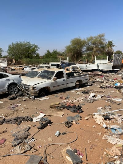
The image shows a scene of destruction in Tayba Alhasanab, Sudan (latitude: 15.36, longitude: 32.528). There are several vehicles, including a white pickup truck in the foreground, and several other vehicles in the background. The vehicles appear to be damaged. The ground is covered in debris and rubble. There are trees and bushes in the background. The image suggests that there has been a recent conflict or disaster.
Tayba Alhasanab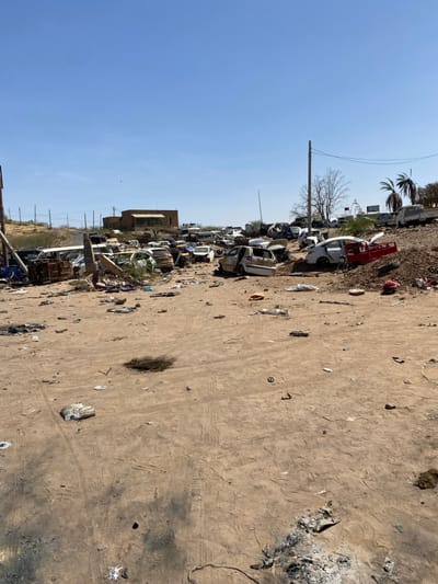
The image depicts a scene of destruction and disarray in Tayba Alhasanab, Sudan. It is a sandy, open area, strewn with debris and wreckage of multiple vehicles. The vehicles are mostly overturned and damaged. There are no people visible in the image. The scene is likely the aftermath of an incident or conflict. A building is visible in the background. The sky is clear and blue.
Tayba Alhasanab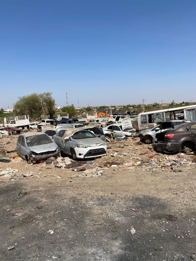
The image shows a large junkyard in Tayba Alhasanab, Sudan (latitude: 15.36, longitude: 32.528), littered with discarded vehicles and debris. There are at least a dozen cars, many of them damaged or missing parts, along with a bus, a truck, and various scattered pieces of metal, fabric, and plastic. The vehicles are arranged haphazardly, and there is no sign of any people present in the scene. The ground is covered in dust and dirt, and the sky is a clear blue.
Tayba Alhasanab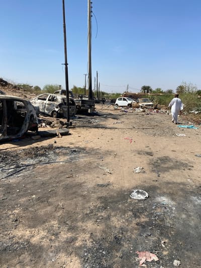
The scene is a street in Tayba Alhasanab, Sudan. The street is covered in dirt and debris, including charred remains of what appears to be a fire. There are several cars parked on the side of the street, some of them burned and charred. A single figure walks away from the scene of the fire in the distance, wearing traditional white clothing. The figure walks away from the camera. There is a utility pole to the left of the image. The environment is dry and dusty, and the sky is blue.
Tayba Alhasanab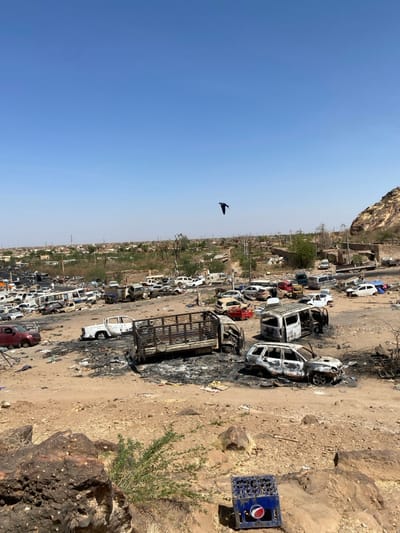
The image shows a wide shot of a large, open area in Tayba Alhasanab, Sudan, characterized by a terrain of sandy soil and scattered rocks. The area is littered with the remains of burnt-out vehicles, including cars, trucks, and SUVs. Some of the vehicles are partially charred, while others are completely destroyed. The remnants of the vehicles are scattered haphazardly across the open space, with tire tracks and debris creating a chaotic scene. A single black bird is soaring in a clear blue sky above the scene. In the distance, a small town can be seen with low-rise buildings surrounded by sparse vegetation. A lone Pepsi crate sits on a large rock in the foreground. The image suggests a aftermath of a conflict or destruction in the area.
Tayba Alhasanab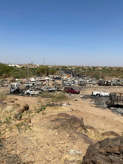
The image shows a large number of burned-out vehicles in Tayba Alhasanab, Sudan, located at coordinates 15.36 latitude and 32.528 longitude. The vehicles are scattered across a dirt field, and some are partially burned. The scene appears to be aftermath of a fire, suggesting the vehicles were intentionally destroyed. The surrounding environment is dry and dusty, with a few trees in the distance.
Tayba Alhasanab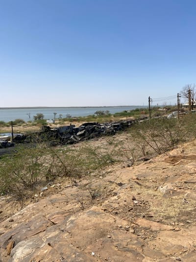
The image shows a view from a rocky hill overlooking a body of water, possibly the Nile River. The location is Tayba Alhasanab, Sudan, with coordinates 15.362, 32.525. The scene is characterized by a vast expanse of water with a clear, blue sky. The ground is covered in rocks and sparse vegetation, with a line of burnt and damaged vehicles clustered near the water's edge. Power lines stretch across the horizon, and several trees can be seen on the distant shore. The image captures a post-conflict or disaster setting.
Tayba Alhasanab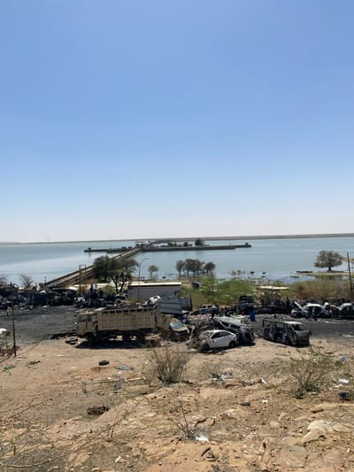
The image shows a scene of destruction in Tayba Alhasanab, Sudan, located at 15.362 latitude and 32.525 longitude. In the foreground, a dirt hill descends toward a debris field. Numerous vehicles, including a large truck, a van, and numerous cars, are charred and damaged, likely from an explosion or fire. The debris field extends towards a partially submerged dam structure, visible in the distance. Trees and sparse vegetation line the water's edge. The sky is clear and blue. There are no people visible in the image.
Tayba Alhasanab