Stake attention in this memory
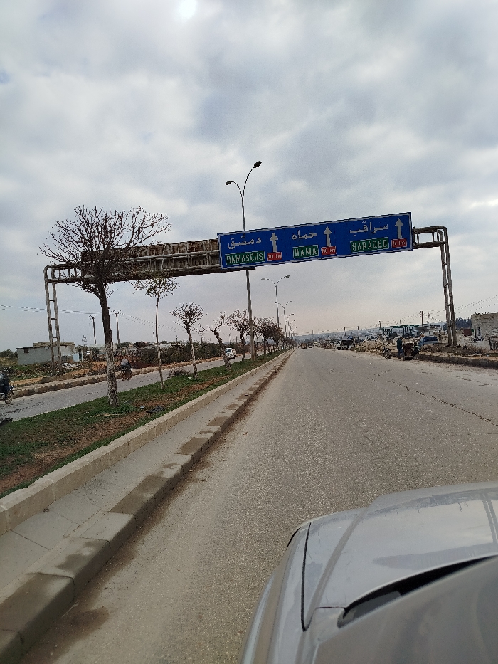
The image captures a forward-facing view from inside a vehicle on a multi-lane asphalt road in Idlib, Syria. The sky is overcast with a bright spot where the sun attempts to break through, indicating daytime. Dominating the upper mid-ground is a large blue overhead road sign, supported by a metal gantry structure. The sign features white Arabic and English text, directing traffic to three destinations: * On the left: Arabic "دمشق" (Damascus) and English "DAMASCUS," indicating a route number "20 TA" and a distance of "73 KM." * In the center: Arabic "حماه" (Hama) and English "HAMA," indicating a route number "72 TA" and a distance of "14 KM." * On the right: Arabic "سراقب" (Saraqeb) and English "SARAQEB," indicating a route number "14 FR" and a distance of "3 KM." This signage precisely places the scene approximately 3 kilometers from Saraqeb, a town within the Idlib Governorate. The road features a concrete median strip planted with sparse, bare trees, suggesting winter or early spring. Several streetlights are visible along the road. In the distance on both sides, there are various buildings and structures, some appearing utilitarian or residential. On the left side of the road, a few motorcycles and distant figures can be seen. The foreground shows a portion of the vehicle's silver hood and windshield, from which the photo was taken. The overall scene depicts a functional but somewhat stark highway environment in rural or semi-urban Syria.
No transactions found