Sign in
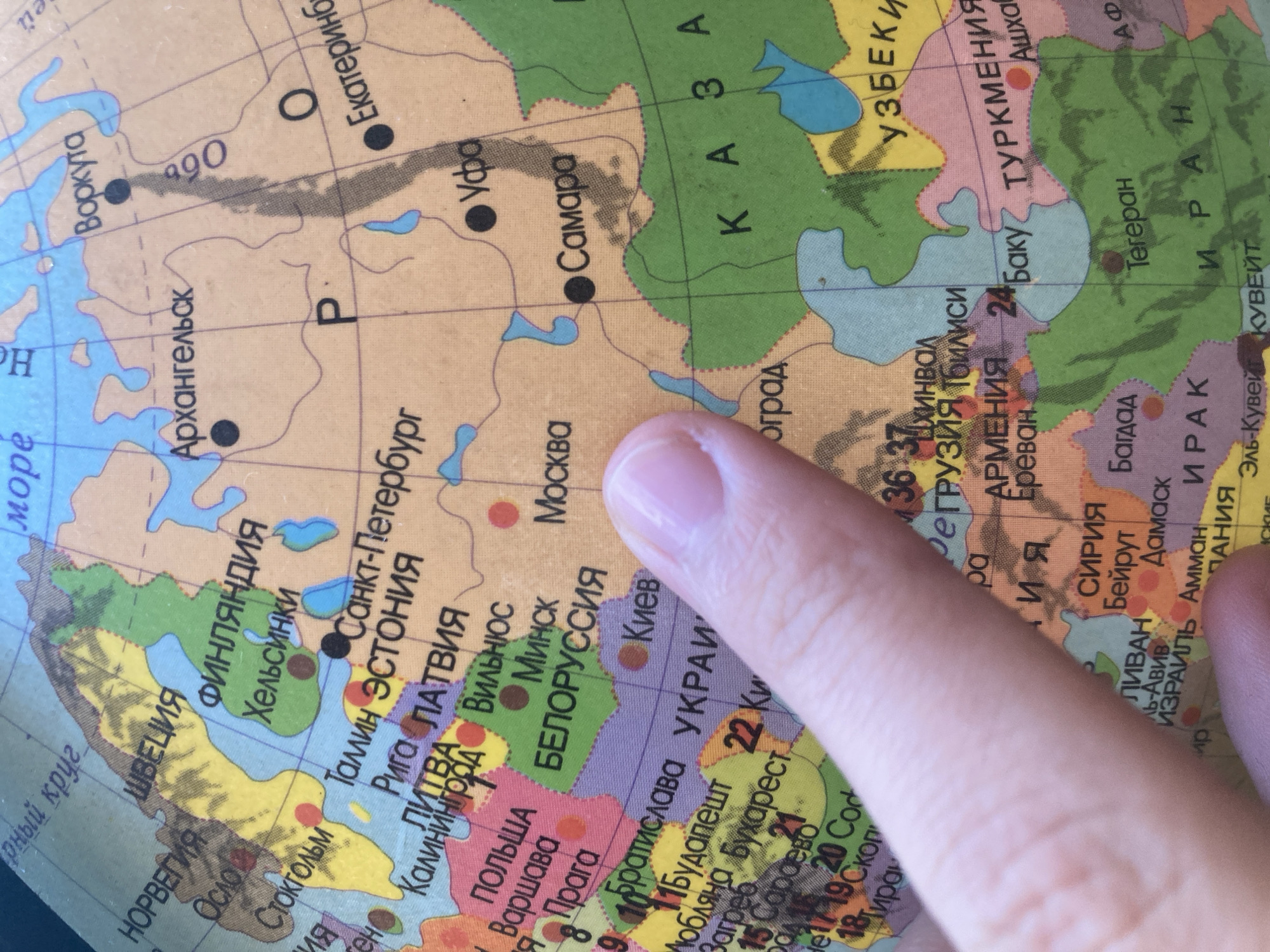
A close-up, high-angle, medium shot captures a portion of a globe displaying a map of Europe and Western Asia. The globe is illuminated by ambient light, causing some glare and slight blurring. A person's right hand, specifically the index finger, is prominently placed on the globe, obscuring parts of Russia and Ukraine. The finger is positioned over the area of Ukraine and the Black Sea.

Visible countries and cities on the map include:

*   **Northern Europe:** Norway, Sweden, Finland, with cities like Oslo, Stockholm, and Helsinki.
*   **Eastern Europe:** Russia, Belarus, Ukraine, Poland, with cities such as Moscow, Minsk, Kyiv, and Warsaw.
*   **Baltic States:** Estonia and Latvia, with Tallinn and Riga.
*   **Caucasus Region:** Georgia, Armenia, Azerbaijan, with cities like Tbilisi, Yerevan, and Baku.
*   **Middle East:** Turkey, Syria, Lebanon, Israel, Jordan, Iraq, Iran, Kuwait, with cities such as Damascus, Beirut, Amman, Baghdad, and Tehran.
*   **Central Asia:** Parts of Kazakhstan and Uzbekistan are visible.
*   **Russia:** Cities like Arkhangelsk, Vorkuta, Ufa, and Yekaterinburg are marked.

The map uses different colors to demarcate countries and has black dots to indicate major cities. Grid lines representing latitude and longitude are visible. The text on the globe is in Cyrillic script. The background is out of focus, suggesting the globe is on a surface.

The location of Besedy, Russia, is not explicitly marked or identifiable on the visible portion of the globe in this image.
Rousebleack

Aug 31, 2026, 3:17 PM

Besedy, Russia

Short Term

Stake attention in this memory

curiosity
learning
exploration
interest
discovery

A close-up, high-angle, medium shot captures a portion of a globe displaying a map of Europe and Western Asia. The globe is illuminated by ambient light, causing some glare and slight blurring. A person's right hand, specifically the index finger, is prominently placed on the globe, obscuring parts of Russia and Ukraine. The finger is positioned over the area of Ukraine and the Black Sea. Visible countries and cities on the map include: * **Northern Europe:** Norway, Sweden, Finland, with cities like Oslo, Stockholm, and Helsinki. * **Eastern Europe:** Russia, Belarus, Ukraine, Poland, with cities such as Moscow, Minsk, Kyiv, and Warsaw. * **Baltic States:** Estonia and Latvia, with Tallinn and Riga. * **Caucasus Region:** Georgia, Armenia, Azerbaijan, with cities like Tbilisi, Yerevan, and Baku. * **Middle East:** Turkey, Syria, Lebanon, Israel, Jordan, Iraq, Iran, Kuwait, with cities such as Damascus, Beirut, Amman, Baghdad, and Tehran. * **Central Asia:** Parts of Kazakhstan and Uzbekistan are visible. * **Russia:** Cities like Arkhangelsk, Vorkuta, Ufa, and Yekaterinburg are marked. The map uses different colors to demarcate countries and has black dots to indicate major cities. Grid lines representing latitude and longitude are visible. The text on the globe is in Cyrillic script. The background is out of focus, suggesting the globe is on a surface. The location of Besedy, Russia, is not explicitly marked or identifiable on the visible portion of the globe in this image.

Symbol

06A24

Volume

11,550

Creator

+$0.03

Revenue

+$0.06

TVL

$2.41

1D
1W
1M
All

Loading AttnAds…

transactions
revenues
stakers
Earliest
Latest
Highest stake

1

REQUIEM

Staked 2h ago

$2.37 USD

+$0.04 USD

+2%

2

Rev Bot 🤖💰

Injected revenue 2h ago

Revenue bonus for the last stake.

+$0.07 USD

More from this user

More from Besedy

Rousebleack

Aug 31, 2026, 3:17 PM

Besedy, Russia

Licensed under Creative Commons Attribution 4.0 International License. You are free to share and adapt this content with proper attribution.