
Sign in
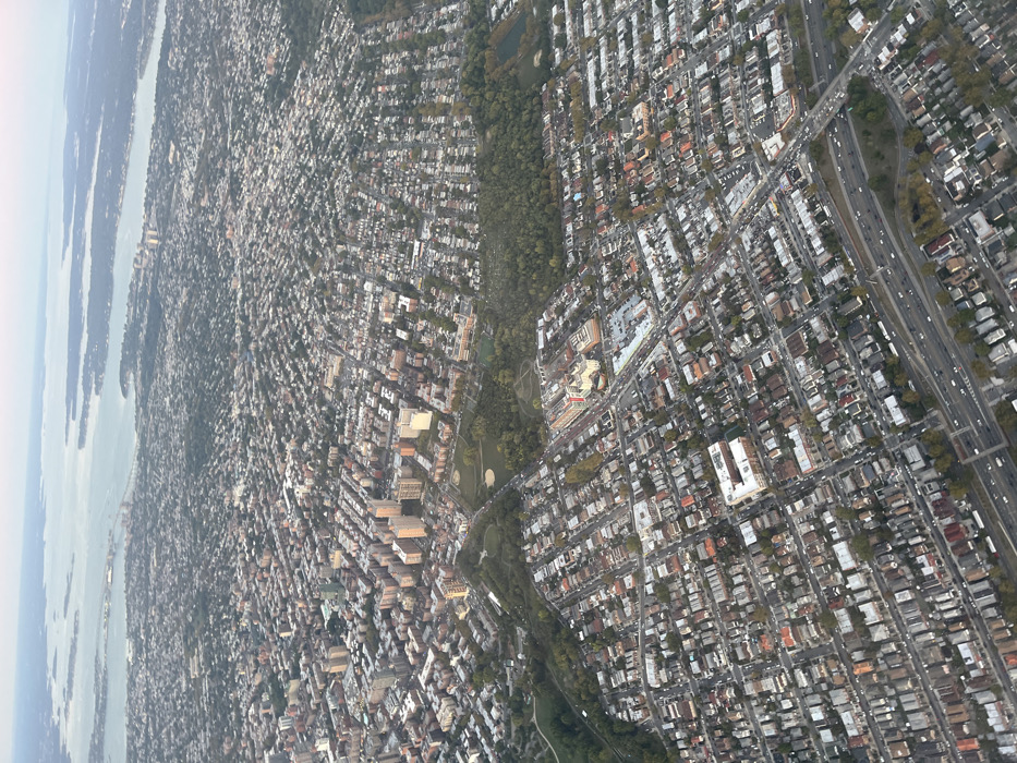
This aerial image depicts a vast expanse of urban and suburban landscape in Queens, New York City, United States, specifically overlooking neighborhoods such as Fresh Meadows, Oakland Gardens, Bayside, Douglaston, and Little Neck. The perspective is from an elevated vantage point, likely an aircraft, looking generally northwest towards the Long Island Sound.

The scene is dominated by a dense arrangement of residential structures. The foreground and mid-ground are characterized by extensive grids of low-rise (one to three-story) detached and semi-detached homes with pitched roofs, interspersed with tree-lined streets. In the upper-left and central-left, a denser concentration of multi-story apartment buildings is visible.

A prominent multi-lane highway, identified as the Clearview Expressway (I-295), diagonally crosses the lower-mid portion of the image, showing moderate vehicle traffic. Local roads create a varied street pattern throughout the residential zones.

Significant green spaces are integrated into the urban fabric. A large, irregularly shaped parkland, consistent with Cunningham Park and Alley Pond Park, features dense tree cover, open grassy areas, and what appears to be a golf course or extensive sports fields. Another notable landmark in the mid-ground right is a large institutional complex, identifiable as Long Island Jewish Medical Center, comprising multiple buildings with distinctive reddish-orange and lighter-colored roofs.

In the distant background, a large body of water, the Long Island Sound and Little Neck Bay, stretches towards the horizon, punctuated by several smaller landmasses. The Throgs Neck Bridge is discernible spanning the water in the upper-left distance.

The sky is a pale blue-grey, indicating diffused light, possibly from early morning, late afternoon, or overcast conditions. Shadows are present but not sharply defined. No individual persons or specific actions are discernible at this altitude; observations are limited to urban infrastructure, architecture, and natural topography.
YG

Oct 2, 2025, 10:36 PM

New York, USA

Stake attention in this memory

Vastness
Density
Urban
Overwhelming
Overview

This aerial image depicts a vast expanse of urban and suburban landscape in Queens, New York City, United States, specifically overlooking neighborhoods such as Fresh Meadows, Oakland Gardens, Bayside, Douglaston, and Little Neck. The perspective is from an elevated vantage point, likely an aircraft, looking generally northwest towards the Long Island Sound. The scene is dominated by a dense arrangement of residential structures. The foreground and mid-ground are characterized by extensive grids of low-rise (one to three-story) detached and semi-detached homes with pitched roofs, interspersed with tree-lined streets. In the upper-left and central-left, a denser concentration of multi-story apartment buildings is visible. A prominent multi-lane highway, identified as the Clearview Expressway (I-295), diagonally crosses the lower-mid portion of the image, showing moderate vehicle traffic. Local roads create a varied street pattern throughout the residential zones. Significant green spaces are integrated into the urban fabric. A large, irregularly shaped parkland, consistent with Cunningham Park and Alley Pond Park, features dense tree cover, open grassy areas, and what appears to be a golf course or extensive sports fields. Another notable landmark in the mid-ground right is a large institutional complex, identifiable as Long Island Jewish Medical Center, comprising multiple buildings with distinctive reddish-orange and lighter-colored roofs. In the distant background, a large body of water, the Long Island Sound and Little Neck Bay, stretches towards the horizon, punctuated by several smaller landmasses. The Throgs Neck Bridge is discernible spanning the water in the upper-left distance. The sky is a pale blue-grey, indicating diffused light, possibly from early morning, late afternoon, or overcast conditions. Shadows are present but not sharply defined. No individual persons or specific actions are discernible at this altitude; observations are limited to urban infrastructure, architecture, and natural topography.

Loading AttnAds…

transactions
revenues
stakers
Earliest
Latest
Highest stake

No transactions found

More from this user

More from New York

YG

Oct 2, 2025, 10:36 PM

New York, USA

Licensed under Creative Commons Attribution 4.0 International License. You are free to share and adapt this content with proper attribution.