Sign in
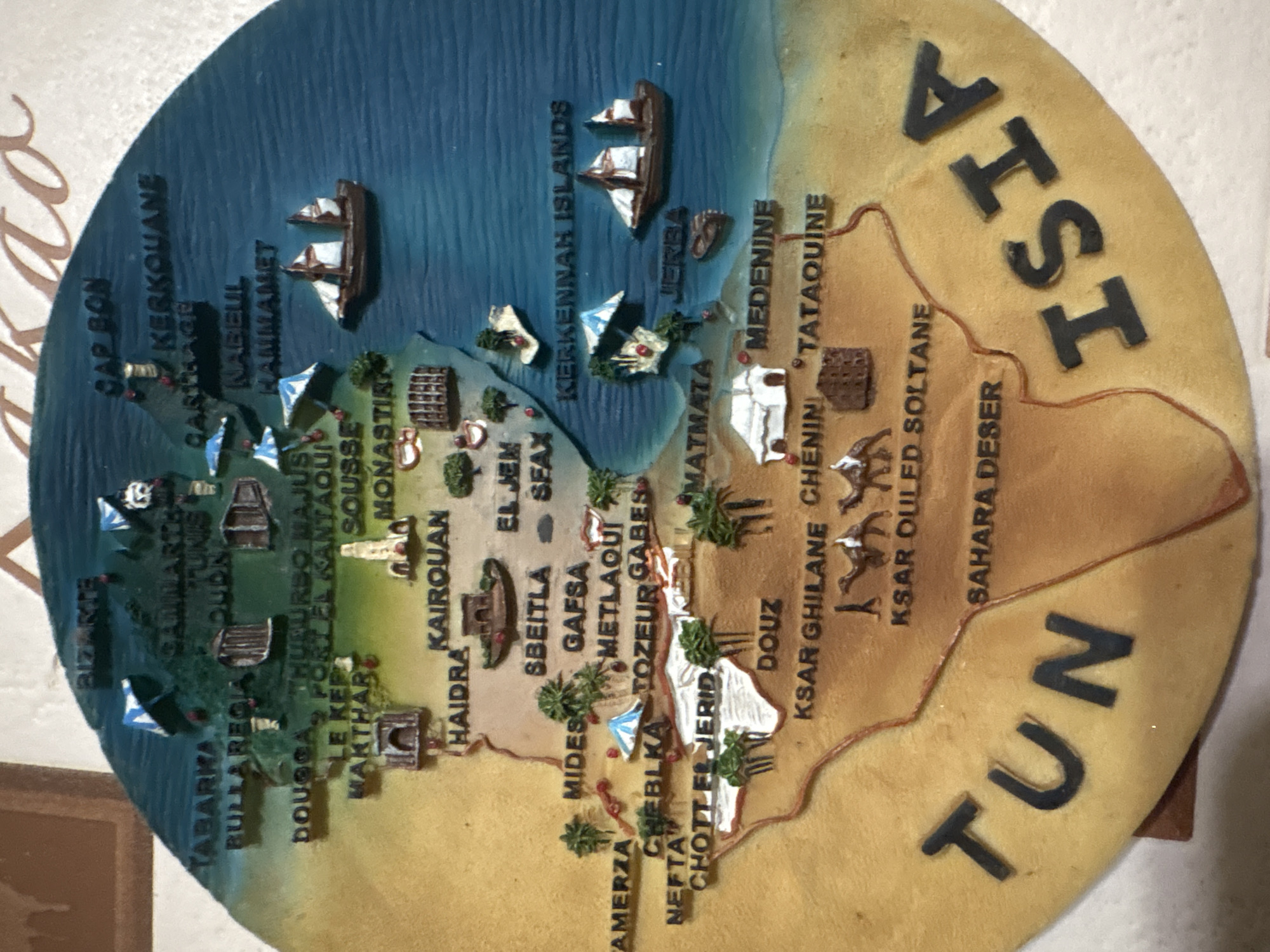
This close-up image displays a three-dimensional, circular relief map of Tunisia. The map is vertically oriented and shows the country's diverse landscape, with blue representing the Mediterranean Sea, green for fertile coastal and northern regions, and various shades of brown for the desert areas, including the Sahara.

The primary subjects are the geographical features and numerous miniature representations of cities, landmarks, and natural elements. Small model ships are visible in the blue sea, and tiny buildings, often stylized to reflect local architecture, are scattered across the land. Miniature trees, particularly palm trees, are also depicted, especially in oases or greener regions.

No activity or event is taking place; the image is a static representation of a country.

Notable details include the tactile nature of the map, with raised areas for mountains and individual structures. The coastline is clearly defined, and specific islands like KERKENNAH ISLANDS and JERBA are present. The desert region is labeled "SAHARA DESER" and features representations of ksars (fortified granaries).

Prominent text labels identify numerous locations, including: "TUNISIA" (partially visible as "TUN" and "ISIA"), "CAP BON", "KERKOUANE", "NABEUL", "HAMMAMET", "SOUSSE", "MONASTIR", "EL JEM", "KAIROUAN", "HAIDRA", "SBEITLA", "SFAX", "GABES", "TOZEUR", "NEFTA", "CHOTT EL JERID", "DOUZ", "MATMATA", "MEDENINE", "TATAOUINE", "KSAR GHILANE", "KSAR OULED SOLTANE", "BIZERTE", "TABARKA", "BULLA REGIA", "TUNIS", "DOUGGA", "LE KEF", "GAFSA", "METLAQUI", and "AMERZA".
FM-l7Wc52

Jun 2, 2026, 6:01 PM

Krasnoyarsk, Russia

Moment

Stake attention in this memory

nostalgic
adventurous
curious
calm
historical

This close-up image displays a three-dimensional, circular relief map of Tunisia. The map is vertically oriented and shows the country's diverse landscape, with blue representing the Mediterranean Sea, green for fertile coastal and northern regions, and various shades of brown for the desert areas, including the Sahara. The primary subjects are the geographical features and numerous miniature representations of cities, landmarks, and natural elements. Small model ships are visible in the blue sea, and tiny buildings, often stylized to reflect local architecture, are scattered across the land. Miniature trees, particularly palm trees, are also depicted, especially in oases or greener regions. No activity or event is taking place; the image is a static representation of a country. Notable details include the tactile nature of the map, with raised areas for mountains and individual structures. The coastline is clearly defined, and specific islands like KERKENNAH ISLANDS and JERBA are present. The desert region is labeled "SAHARA DESER" and features representations of ksars (fortified granaries). Prominent text labels identify numerous locations, including: "TUNISIA" (partially visible as "TUN" and "ISIA"), "CAP BON", "KERKOUANE", "NABEUL", "HAMMAMET", "SOUSSE", "MONASTIR", "EL JEM", "KAIROUAN", "HAIDRA", "SBEITLA", "SFAX", "GABES", "TOZEUR", "NEFTA", "CHOTT EL JERID", "DOUZ", "MATMATA", "MEDENINE", "TATAOUINE", "KSAR GHILANE", "KSAR OULED SOLTANE", "BIZERTE", "TABARKA", "BULLA REGIA", "TUNIS", "DOUGGA", "LE KEF", "GAFSA", "METLAQUI", and "AMERZA".

Symbol

0A960

Volume

744

Creator

+$0.00

Revenue

+$0.00

TVL

$0.03

1D
1W
1M
All

Loading AttnAds…

transactions
revenues
stakers
Earliest
Latest
Highest stake

1

FM-9onED2

Staked 2mo ago

$0.03 USD

+$0.00 USD

+1.0%

2

Rev Bot 🤖💰

Injected revenue 2mo ago

Revenue bonus for the last stake.

+$0.00 USD

More from this user

More from Krasnoyarsk

FM-l7Wc52

Jun 2, 2026, 6:01 PM

Krasnoyarsk, Russia

Licensed under Creative Commons Attribution 4.0 International License. You are free to share and adapt this content with proper attribution.