Sign in
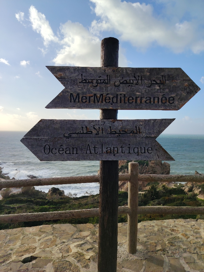
A rustic wooden signpost stands prominently in the foreground, featuring two arrow-shaped planks pointing in opposite directions. The top plank, pointing to the right, displays "البحر الأبيض المتوسط" in Arabic and "Mer Méditerranée" in French, indicating the Mediterranean Sea. The bottom plank, pointing to the left, reads "المحيط الأطلسي" in Arabic and "Océan Atlantique" in French, directing towards the Atlantic Ocean. Both signs are crafted from weathered wood with dark, stenciled lettering.

The scene captures a bright, clear day under a partly cloudy blue sky. To the right, in the direction of the Mediterranean, the sea appears calm and a vibrant blue. To the left, aligning with the Atlantic, the water is more turbulent, with white-capped waves crashing against a rugged, rocky coastline. Verdant green vegetation covers the cliffs and slopes leading down to the water. A simple wooden fence stretches across the mid-ground, providing a barrier along the cliff edge. In the immediate foreground, a stone-paved area or wall is visible.

There are no people visible in the image. The sign serves as a clear geographical marker at a point where the two major bodies of water meet, consistent with its location in Tangier, Morocco, near the Strait of Gibraltar. The light suggests it is either late morning or early afternoon.
Gogii

Jan 23, 2026, 4:30 PM

Tangier, Morocco

Stake attention in this memory

signpost
ocean
multilingual
wooden
travel

A rustic wooden signpost stands prominently in the foreground, featuring two arrow-shaped planks pointing in opposite directions. The top plank, pointing to the right, displays "البحر الأبيض المتوسط" in Arabic and "Mer Méditerranée" in French, indicating the Mediterranean Sea. The bottom plank, pointing to the left, reads "المحيط الأطلسي" in Arabic and "Océan Atlantique" in French, directing towards the Atlantic Ocean. Both signs are crafted from weathered wood with dark, stenciled lettering. The scene captures a bright, clear day under a partly cloudy blue sky. To the right, in the direction of the Mediterranean, the sea appears calm and a vibrant blue. To the left, aligning with the Atlantic, the water is more turbulent, with white-capped waves crashing against a rugged, rocky coastline. Verdant green vegetation covers the cliffs and slopes leading down to the water. A simple wooden fence stretches across the mid-ground, providing a barrier along the cliff edge. In the immediate foreground, a stone-paved area or wall is visible. There are no people visible in the image. The sign serves as a clear geographical marker at a point where the two major bodies of water meet, consistent with its location in Tangier, Morocco, near the Strait of Gibraltar. The light suggests it is either late morning or early afternoon.

Loading AttnAds…

transactions
revenues
stakers
Earliest
Latest
Highest stake

No transactions found

More from this user

More from Tangier

Gogii

Jan 23, 2026, 4:30 PM

Tangier, Morocco

Licensed under Creative Commons Attribution 4.0 International License. You are free to share and adapt this content with proper attribution.