
Sign in
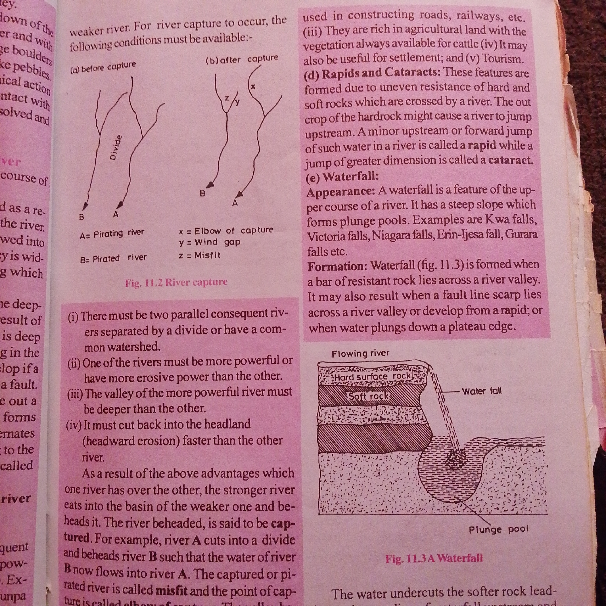
This media file is an image of a textbook page discussing river capture and waterfalls. The subjects are diagrams of rivers, geological formations, and accompanying text. One diagram, labeled "Fig. 11.2 River capture," illustrates the process of river capture with two stages: "before capture" and "after capture." It shows two rivers, labeled A and B, separated by a "Divide." The text explains the conditions for river capture, defining terms like "Pirating river," "Pirated river," "Elbow of capture," "Wind gap," and "Misfit."

Another diagram, labeled "Fig. 11.3 A Waterfall," depicts a cross-section of a river forming a waterfall. It shows layers of "Hard surface rock" and "Soft rock," a "Water fall," and a "Plunge pool" at the base. The text describes the appearance and formation of waterfalls, listing examples like Kwa falls and Niagara falls.

The visible text provides educational content about geographical features, including the conditions required for river capture, the definition and formation of rapids, cataracts, and waterfalls, and examples of famous waterfalls. The image itself does not depict people or specific emotions, but rather instructional diagrams and explanatory text. The location context of Jalingo, Nigeria, is not directly referenced in the image content. The time of day and weather are not discernible.
FM-66btC3

Jun 30, 2026, 4:05 PM

Jalingo, Nigeria

Moment

Stake attention in this memory

educational
informative
diagrammatic
natural science
geography

This media file is an image of a textbook page discussing river capture and waterfalls. The subjects are diagrams of rivers, geological formations, and accompanying text. One diagram, labeled "Fig. 11.2 River capture," illustrates the process of river capture with two stages: "before capture" and "after capture." It shows two rivers, labeled A and B, separated by a "Divide." The text explains the conditions for river capture, defining terms like "Pirating river," "Pirated river," "Elbow of capture," "Wind gap," and "Misfit." Another diagram, labeled "Fig. 11.3 A Waterfall," depicts a cross-section of a river forming a waterfall. It shows layers of "Hard surface rock" and "Soft rock," a "Water fall," and a "Plunge pool" at the base. The text describes the appearance and formation of waterfalls, listing examples like Kwa falls and Niagara falls. The visible text provides educational content about geographical features, including the conditions required for river capture, the definition and formation of rapids, cataracts, and waterfalls, and examples of famous waterfalls. The image itself does not depict people or specific emotions, but rather instructional diagrams and explanatory text. The location context of Jalingo, Nigeria, is not directly referenced in the image content. The time of day and weather are not discernible.

Symbol

1E8A8

Volume

3,199

Creator

+$0.00

Revenue

+$0.01

TVL

$0.25

1D
1W
1M
All

Loading AttnAds…

transactions
revenues
stakers
Earliest
Latest
Highest stake

1

FM-mmBz23

Staked 1mo ago

$0.25 USD

+$0.00 USD

+1%

2

Rev Bot 🤖💰

Injected revenue 1mo ago

Revenue bonus for the last stake.

+$0.01 USD

More from this user

More from Jalingo

FM-66btC3

Jun 30, 2026, 4:05 PM

Jalingo, Nigeria

Licensed under Creative Commons Attribution 4.0 International License. You are free to share and adapt this content with proper attribution.