
Sign in
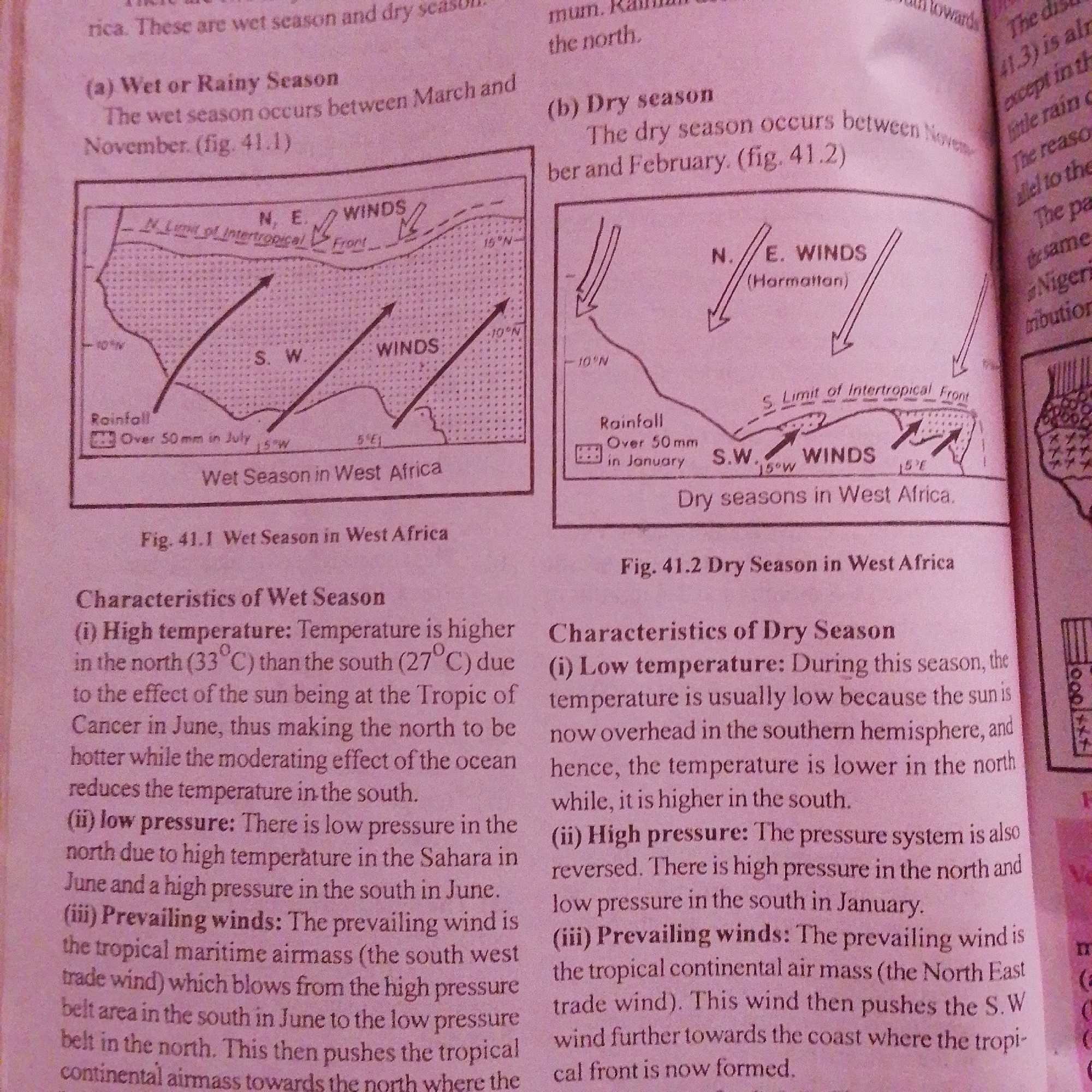
This is a close-up, slightly angled photograph of an open textbook page. The page contains text and illustrations related to the seasons in West Africa, specifically focusing on the wet and dry seasons.

The top section of the page is dedicated to the "Wet or Rainy Season" and includes a diagram labeled "Fig. 41.1 Wet Season in West Africa." This diagram depicts a map of West Africa with wind patterns indicated by arrows, labeled "WINDS" and "N. E. WINDS (Harmattan)". It also shows the "S. Limit of Intertropical Front" and a legend for "Rainfall Over 50 mm in July." Below the diagram, bullet points describe the "Characteristics of Wet Season," including high temperature, low pressure, and prevailing winds.

To the right of the wet season section is the "Dry season" section, with a corresponding diagram labeled "Fig. 41.2 Dry Season in West Africa." This diagram also illustrates wind patterns and the "S. Limit of Intertropical Front" in West Africa, with a rainfall legend indicating "Over 50mm in January." The "Characteristics of Dry Season" are also described in bullet points, covering low temperature, high pressure, and prevailing winds.

The text discusses the geographical and meteorological aspects of these seasons, mentioning temperatures in degrees Celsius and specific months like March, November, January, and June. The location context of Jalingo, Nigeria, is relevant to the regional climate described in the text and diagrams. There is no visible depiction of people or any specific time of day or weather conditions beyond what is described in the text. The setting is clearly an educational context, likely a classroom or study area.
FM-66btC3

Jun 30, 2026, 4:22 PM

Jalingo, Nigeria

Moment

Stake attention in this memory

informative
educational
comparative
analytical
descriptive

This is a close-up, slightly angled photograph of an open textbook page. The page contains text and illustrations related to the seasons in West Africa, specifically focusing on the wet and dry seasons. The top section of the page is dedicated to the "Wet or Rainy Season" and includes a diagram labeled "Fig. 41.1 Wet Season in West Africa." This diagram depicts a map of West Africa with wind patterns indicated by arrows, labeled "WINDS" and "N. E. WINDS (Harmattan)". It also shows the "S. Limit of Intertropical Front" and a legend for "Rainfall Over 50 mm in July." Below the diagram, bullet points describe the "Characteristics of Wet Season," including high temperature, low pressure, and prevailing winds. To the right of the wet season section is the "Dry season" section, with a corresponding diagram labeled "Fig. 41.2 Dry Season in West Africa." This diagram also illustrates wind patterns and the "S. Limit of Intertropical Front" in West Africa, with a rainfall legend indicating "Over 50mm in January." The "Characteristics of Dry Season" are also described in bullet points, covering low temperature, high pressure, and prevailing winds. The text discusses the geographical and meteorological aspects of these seasons, mentioning temperatures in degrees Celsius and specific months like March, November, January, and June. The location context of Jalingo, Nigeria, is relevant to the regional climate described in the text and diagrams. There is no visible depiction of people or any specific time of day or weather conditions beyond what is described in the text. The setting is clearly an educational context, likely a classroom or study area.

Symbol

1F334

Volume

9,630

Creator

+$0.02

Revenue

+$0.05

TVL

$1.95

1D
1W
1M
All

Loading AttnAds…

transactions
revenues
stakers
Earliest
Latest
Highest stake

1

FM-mmBz23

Staked 1mo ago

$1.92 USD

+$0.03 USD

+2%

2

Rev Bot 🤖💰

Injected revenue 1mo ago

Revenue bonus for the last stake.

+$0.06 USD

More from this user

More from Jalingo

FM-66btC3

Jun 30, 2026, 4:22 PM

Jalingo, Nigeria

Licensed under Creative Commons Attribution 4.0 International License. You are free to share and adapt this content with proper attribution.