Stake attention in this memory
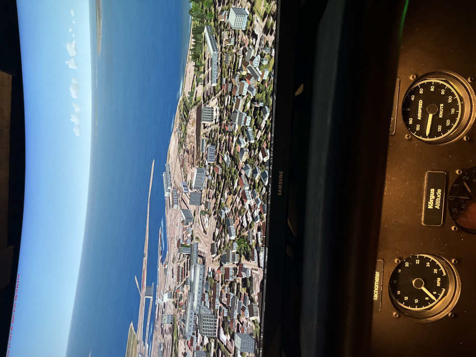
The image displays a flight simulation setup, featuring a monitor showing an aerial city view alongside an aircraft's instrument panel. The picture is rotated 90 degrees clockwise, presenting the monitor vertically and the instrument panel to its right. The left side of the image is dominated by a Samsung monitor, which displays a vibrant, sunlit aerial perspective of a coastal city, identified as Tallinn, Estonia, based on the provided context and visible cues. The simulated landscape includes dense urban buildings, green areas, and a prominent coastline. A wide expanse of deep blue water, featuring long piers or breakwaters, stretches into the distance under a clear, bright blue sky with sparse clouds. To the right, a dark instrument panel is visible, housing three analog gauges. The uppermost gauge is an airspeed indicator, clearly marked "AIRSPEED" and "KNOTS," with its needle pointing close to 150 knots. Below it, an altimeter is present, labeled "Kõrgus" (Estonian for 'Altitude') and "Altitude," showing an "ALT" marking and indicating an altitude (around 920 or 9200 units, difficult to precisely discern the scale). The lowest gauge is a tachometer, labeled "Tachometer" and "RPM," with its needle indicating approximately 14 or 15 (likely representing 1400 or 1500 RPM). Visible text includes "SAMSUNG" on the monitor bezel, and on the instrument panel: "AIRSPEED", "KNOTS", "Kõrgus", "Altitude", "ALT", "Tachometer", and "RPM", along with various numerical scales on the dials. The scene captures an ongoing flight simulation activity.
No transactions found