
Sign in
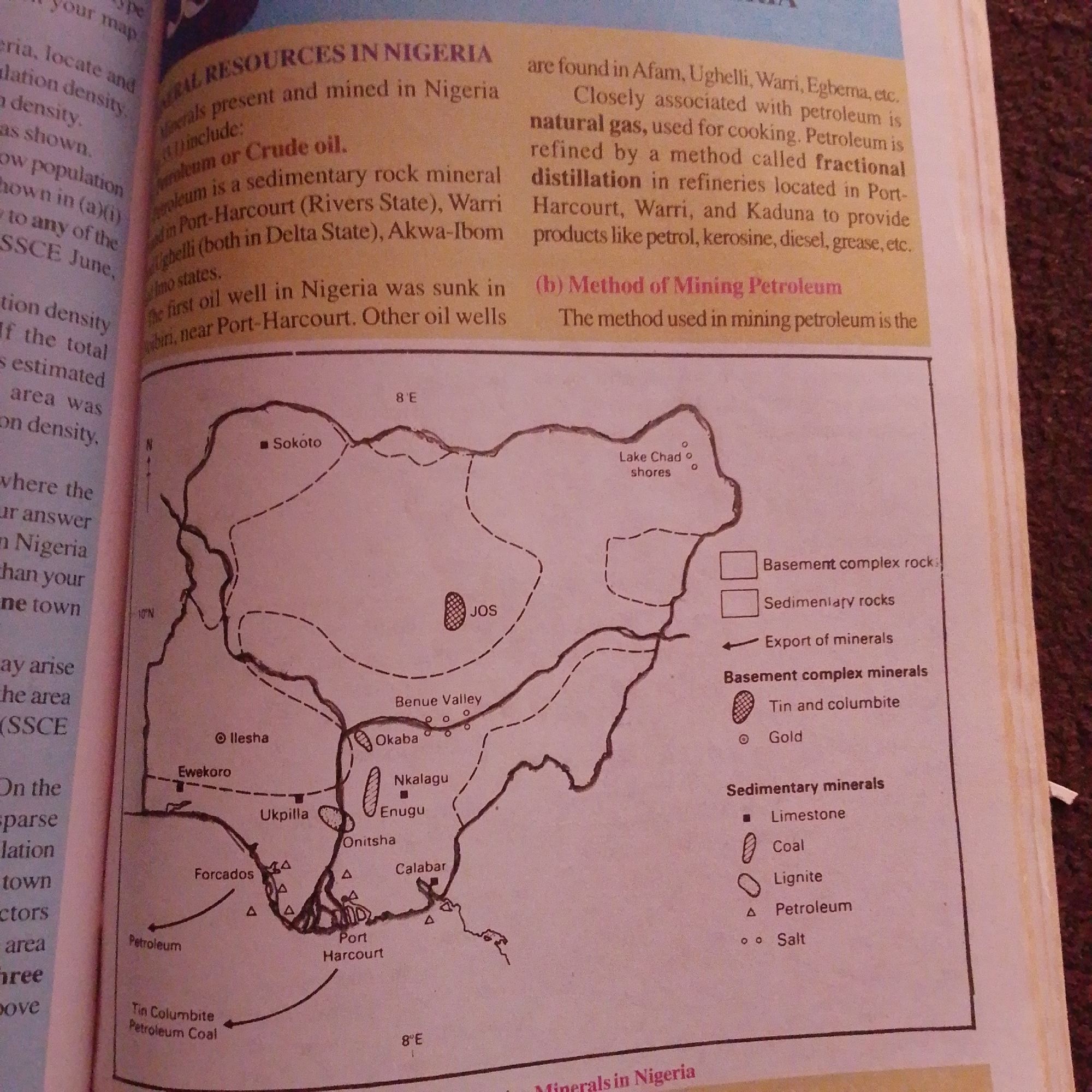
This is a medium shot of an open book, displaying a page with text and a map. The page is oriented vertically, with the top edge of the book visible at the top of the frame. The text discusses "MINERAL RESOURCES IN NIGERIA," specifically mentioning petroleum, natural gas, and their mining methods. It lists various locations in Nigeria associated with these resources, such as Port-Harcourt, Warri, and Ughelli. A map of Nigeria is prominently featured, with shaded areas and symbols indicating different rock types and mineral deposits. Cities like Sokoto, Jos, and Enugu are labeled, along with geographical features like the Benue Valley and Lake Chad. A legend on the right side of the map explains the symbols for "Basement complex rocks," "Sedimentary rocks," and various "Basement complex minerals" (Tin and columbite, Gold) and "Sedimentary minerals" (Limestone, Coal, Lignite, Petroleum, Salt). Arrows indicate the export of minerals. The overall impression is an educational or informational document, likely from a textbook or atlas, focusing on Nigeria's natural resources. The lighting suggests an indoor environment, possibly with ambient daylight. There are no people or specific activities visible beyond the presentation of information.
FM-66btC3

Jun 30, 2026, 4:18 PM

Jalingo, Nigeria

Moment

Stake attention in this memory

informative
educational
geographical
resourceful
detailed

This is a medium shot of an open book, displaying a page with text and a map. The page is oriented vertically, with the top edge of the book visible at the top of the frame. The text discusses "MINERAL RESOURCES IN NIGERIA," specifically mentioning petroleum, natural gas, and their mining methods. It lists various locations in Nigeria associated with these resources, such as Port-Harcourt, Warri, and Ughelli. A map of Nigeria is prominently featured, with shaded areas and symbols indicating different rock types and mineral deposits. Cities like Sokoto, Jos, and Enugu are labeled, along with geographical features like the Benue Valley and Lake Chad. A legend on the right side of the map explains the symbols for "Basement complex rocks," "Sedimentary rocks," and various "Basement complex minerals" (Tin and columbite, Gold) and "Sedimentary minerals" (Limestone, Coal, Lignite, Petroleum, Salt). Arrows indicate the export of minerals. The overall impression is an educational or informational document, likely from a textbook or atlas, focusing on Nigeria's natural resources. The lighting suggests an indoor environment, possibly with ambient daylight. There are no people or specific activities visible beyond the presentation of information.

Symbol

2DDD7

Volume

2,905

Creator

+$0.00

Revenue

+$0.00

TVL

$0.22

1D
1W
1M
All

Loading AttnAds…

transactions
revenues
stakers
Earliest
Latest
Highest stake

1

FM-mmBz23

Staked 1mo ago

$0.22 USD

+$0.00 USD

+1%

2

Rev Bot 🤖💰

Injected revenue 1mo ago

Revenue bonus for the last stake.

+$0.00 USD

More from this user

More from Jalingo

FM-66btC3

Jun 30, 2026, 4:18 PM

Jalingo, Nigeria

Licensed under Creative Commons Attribution 4.0 International License. You are free to share and adapt this content with proper attribution.