Sign in
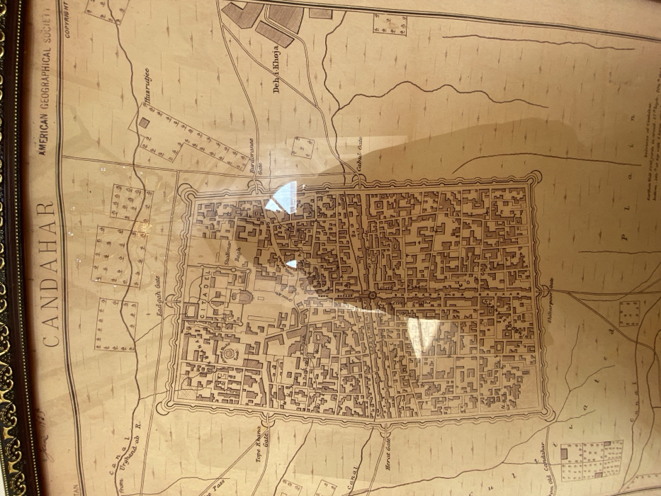
The image displays an antique, sepia-toned map titled "CANDAHAR" by the "AMERICAN GEOGRAPHICAL SOCIETY," presented within a dark, ornate frame and covered by a reflective glass surface. The map depicts a detailed plan of Kandahar, Afghanistan, centered on a fortified, walled city with a rectangular perimeter.

Inside the city walls, a dense grid of buildings and streets is illustrated, featuring key landmarks such as a "CITADEL" in the northern section, a "Shalimar Bagh" to its east, and a "Tomb" to its west. A prominent central thoroughfare, labeled "40 yards wide," traverses the city.

The city walls are punctuated by multiple labeled gates, including "Lad-gah Gate" (north), "Tope Khana Gate" (west), "Herat Gate" (southwest), "Shikarpur Gate" (south), "Cabul Gate" (southeast), and "Burdoranee Gate" (east).

The area surrounding the walled city shows a "Canal from Urghand ab R." in the northwest, along with various roads emanating from the gates. Several parcels of land are marked with small squares containing tree symbols, indicating cultivated or green areas. Specific locations outside the city walls include "Musrutjee" to the northeast and "Deh-i Khoja" to the east. A partially visible legend in the bottom right corner notes details about the "Further Wall," specifying its circuit, height, and thickness.

Bright, irregular reflections are visible on the glass surface, partially obscuring the map's details, particularly in the central-lower and mid-right sections. No individuals or active interactions are present in the image; the focus is solely on the framed map.
Wahid_Rahman_Afghanmal

Jan 6, 2026, 7:00 AM

Kandahar, Afghanistan

Stake attention in this memory

Nostalgia
Curiosity
Intrigue
Serenity
History

The image displays an antique, sepia-toned map titled "CANDAHAR" by the "AMERICAN GEOGRAPHICAL SOCIETY," presented within a dark, ornate frame and covered by a reflective glass surface. The map depicts a detailed plan of Kandahar, Afghanistan, centered on a fortified, walled city with a rectangular perimeter. Inside the city walls, a dense grid of buildings and streets is illustrated, featuring key landmarks such as a "CITADEL" in the northern section, a "Shalimar Bagh" to its east, and a "Tomb" to its west. A prominent central thoroughfare, labeled "40 yards wide," traverses the city. The city walls are punctuated by multiple labeled gates, including "Lad-gah Gate" (north), "Tope Khana Gate" (west), "Herat Gate" (southwest), "Shikarpur Gate" (south), "Cabul Gate" (southeast), and "Burdoranee Gate" (east). The area surrounding the walled city shows a "Canal from Urghand ab R." in the northwest, along with various roads emanating from the gates. Several parcels of land are marked with small squares containing tree symbols, indicating cultivated or green areas. Specific locations outside the city walls include "Musrutjee" to the northeast and "Deh-i Khoja" to the east. A partially visible legend in the bottom right corner notes details about the "Further Wall," specifying its circuit, height, and thickness. Bright, irregular reflections are visible on the glass surface, partially obscuring the map's details, particularly in the central-lower and mid-right sections. No individuals or active interactions are present in the image; the focus is solely on the framed map.

Loading AttnAds…

transactions
revenues
stakers
Earliest
Latest
Highest stake

No transactions found

More from this user

More from Kandahar

Wahid_Rahman_Afghanmal

Jan 6, 2026, 7:00 AM

Kandahar, Afghanistan

Licensed under Creative Commons Attribution 4.0 International License. You are free to share and adapt this content with proper attribution.