
Sign in
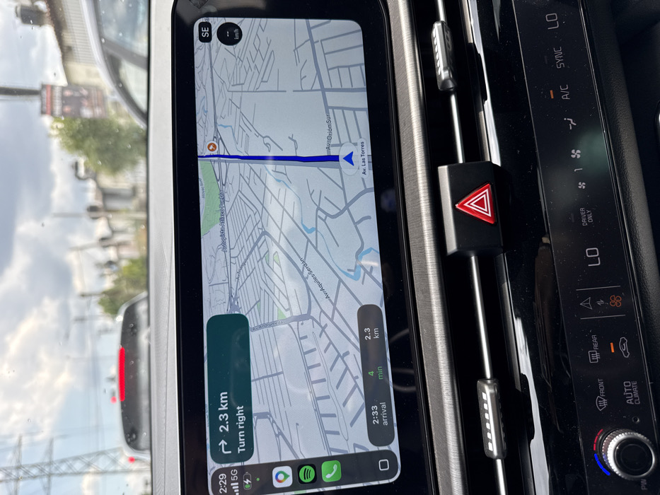
The image displays the interior of a vehicle, primarily focusing on the dashboard and the view through the windshield, taken in the city of San Bernardino Tlaxcalancingo, Mexico. An infotainment screen dominates the upper center, showing Apple Maps navigation. The map illustrates a route with the current vehicle position on "Av. Las Torres," instructing to "Turn right" in 2.3 kilometers. Roads such as "Autopista Atlixco Puebla" and "Av. Aquiles Serdán" are labeled on the map, along with "Av. Orión Sur" as part of the route. The screen indicates a 5G cellular connection, the time 2:29, and an estimated arrival at 2:33 (4 minutes) covering 2.3 km. A Spotify app icon is visible on the left edge of the screen.

Below the screen, a black, textured dashboard features a red triangular hazard light button in the center, flanked by silver-colored air vent control sliders. The lower portion of the dashboard reveals climate control settings, including a temperature dial with blue and red indicators, and buttons labeled "AUTO CLIMATE," "FRONT," "REAR," "LO," "A/C," and "SYNC."

Through the windshield, which has visible water spots, an overcast sky with grey clouds is apparent. Directly ahead of the vehicle, the rear of a white car with illuminated red taillights is visible, suggesting traffic or a stopped position. In the background, power lines are present on the left, and indistinct urban structures and vegetation are visible under the cloudy conditions. No people are depicted in the scene.
valerio

Mar 23, 2026, 8:29 PM

San Bernardino Tlaxcalancingo, Mexico

Stake attention in this memory

Navigation
Anticipation
Focus
Control
Urgency

The image displays the interior of a vehicle, primarily focusing on the dashboard and the view through the windshield, taken in the city of San Bernardino Tlaxcalancingo, Mexico. An infotainment screen dominates the upper center, showing Apple Maps navigation. The map illustrates a route with the current vehicle position on "Av. Las Torres," instructing to "Turn right" in 2.3 kilometers. Roads such as "Autopista Atlixco Puebla" and "Av. Aquiles Serdán" are labeled on the map, along with "Av. Orión Sur" as part of the route. The screen indicates a 5G cellular connection, the time 2:29, and an estimated arrival at 2:33 (4 minutes) covering 2.3 km. A Spotify app icon is visible on the left edge of the screen. Below the screen, a black, textured dashboard features a red triangular hazard light button in the center, flanked by silver-colored air vent control sliders. The lower portion of the dashboard reveals climate control settings, including a temperature dial with blue and red indicators, and buttons labeled "AUTO CLIMATE," "FRONT," "REAR," "LO," "A/C," and "SYNC." Through the windshield, which has visible water spots, an overcast sky with grey clouds is apparent. Directly ahead of the vehicle, the rear of a white car with illuminated red taillights is visible, suggesting traffic or a stopped position. In the background, power lines are present on the left, and indistinct urban structures and vegetation are visible under the cloudy conditions. No people are depicted in the scene.

Loading AttnAds…

transactions
revenues
stakers
Earliest
Latest
Highest stake

No transactions found

More from this user

More from San Bernardino Tlaxcalancingo

valerio

Mar 23, 2026, 8:29 PM

San Bernardino Tlaxcalancingo, Mexico

Licensed under Creative Commons Attribution 4.0 International License. You are free to share and adapt this content with proper attribution.