
Sign in
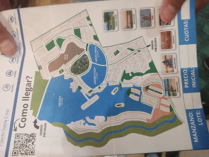
A pair of hands holds a promotional brochure or map titled "Puerto Santa Cruz," likely for a residential real estate development. The brochure is oriented diagonally, and the hands are visible at the top left and top right, supporting it.

The central feature of the brochure is a detailed map showcasing a community with numerous residential plots, roads, and large blue bodies of water labeled "LAGUNA 1 PESCA," "LAGUNA 2 PESCA," and "LAGUNA 3." An area marked "4X4" suggests off-road activities. The map also indicates two entry points: "INGRESO POR URUBO" (Entrance via Urubó) and "INGRESO POR BELGICA" (Entrance via Bélgica/Belgrano).

To the left of the map, under the "Puerto Santa Cruz" branding, are icons with labels like "PISCINAS" (pools), "CABAÑAS" (cabins, though OCR reads "CASARAS"), and "AMP" (likely an abbreviation for an amenity). A QR code is present in the bottom left corner.

On the right side of the brochure, there are fields for potential buyers: "MANZANO:" (Block), "LOTE:" (Lot), "PRECIO:" (Price), "INICIAL:" (Initial Payment), and "CUOTAS:" (Installments). Adjacent to these fields are small illustrative images, some with labels like "LAGUNA DE PESCA" (fishing lagoon) and "LAGUNA UNIVERSAL" (universal lagoon). The brochure also features the question "Como llegar?" (How to get there?), suggesting it's providing directions or access information. Given the context of La Paz, Bolivia, this development is likely situated in or near that region.
FM-2vcBI3

Dec 14, 2024, 9:20 PM

La Paz, Bolivia

Stake attention in this memory

A pair of hands holds a promotional brochure or map titled "Puerto Santa Cruz," likely for a residential real estate development. The brochure is oriented diagonally, and the hands are visible at the top left and top right, supporting it. The central feature of the brochure is a detailed map showcasing a community with numerous residential plots, roads, and large blue bodies of water labeled "LAGUNA 1 PESCA," "LAGUNA 2 PESCA," and "LAGUNA 3." An area marked "4X4" suggests off-road activities. The map also indicates two entry points: "INGRESO POR URUBO" (Entrance via Urubó) and "INGRESO POR BELGICA" (Entrance via Bélgica/Belgrano). To the left of the map, under the "Puerto Santa Cruz" branding, are icons with labels like "PISCINAS" (pools), "CABAÑAS" (cabins, though OCR reads "CASARAS"), and "AMP" (likely an abbreviation for an amenity). A QR code is present in the bottom left corner. On the right side of the brochure, there are fields for potential buyers: "MANZANO:" (Block), "LOTE:" (Lot), "PRECIO:" (Price), "INICIAL:" (Initial Payment), and "CUOTAS:" (Installments). Adjacent to these fields are small illustrative images, some with labels like "LAGUNA DE PESCA" (fishing lagoon) and "LAGUNA UNIVERSAL" (universal lagoon). The brochure also features the question "Como llegar?" (How to get there?), suggesting it's providing directions or access information. Given the context of La Paz, Bolivia, this development is likely situated in or near that region.

Loading AttnAds…

transactions
revenues
stakers
Earliest
Latest
Highest stake

No transactions found

More from this user

More from La Paz

FM-2vcBI3

Dec 14, 2024, 9:20 PM

La Paz, Bolivia

Licensed under Creative Commons Attribution 4.0 International License. You are free to share and adapt this content with proper attribution.