
Sign in
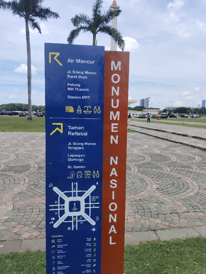
This media file captures a tall, dual-paneled directional signpost situated in a spacious outdoor area, characteristic of a public park or monument complex. The right panel, rendered in orange, prominently displays "MONUMEN NASIONAL" (National Monument) in vertical white lettering. The wider blue panel on the left provides visitor information and directions, divided into sections.

The upper section directs visitors towards "Air Mancur" (Fountain), "Patung MH Thamrin" (MH Thamrin Statue), and "Stasiun MRT" (MRT Station) in the "Jl. Silang Monas Barat Daya" area, accompanied by icons for transportation, a fountain, and restrooms. A lower section points to "Taman Refleksi" (Reflection Garden), "Lapangan Olahraga" (Sports Field), and "St. Gambir" (Gambir Station) in the "Jl. Silang Monas Tenggara" area, with icons for greenery, bus, building, restrooms, and people. A stylized map of the Monas area occupies the bottom of the blue panel, detailing various facilities and landmarks, with a legend providing explanations for symbols representing public toilets, parking, food stalls, entrances, exits, and key locations like Istiqlal Mosque, National Museum, and the State Palace.

In the background, tall palm trees flank a visible portion of a large, white monument, strongly suggesting the National Monument (Monas) in Central Jakarta, Indonesia. Beyond the paved ground with intricate circular patterns and areas of grass, distant vehicles are parked, and a few individuals are seen walking. The bright, cloudy sky indicates it is daytime with fair weather, setting a clear scene of a major public attraction.
FM-uRiyY2

Feb 20, 2025, 5:39 AM

Central Jakarta, Indonesia

Stake attention in this memory

This media file captures a tall, dual-paneled directional signpost situated in a spacious outdoor area, characteristic of a public park or monument complex. The right panel, rendered in orange, prominently displays "MONUMEN NASIONAL" (National Monument) in vertical white lettering. The wider blue panel on the left provides visitor information and directions, divided into sections. The upper section directs visitors towards "Air Mancur" (Fountain), "Patung MH Thamrin" (MH Thamrin Statue), and "Stasiun MRT" (MRT Station) in the "Jl. Silang Monas Barat Daya" area, accompanied by icons for transportation, a fountain, and restrooms. A lower section points to "Taman Refleksi" (Reflection Garden), "Lapangan Olahraga" (Sports Field), and "St. Gambir" (Gambir Station) in the "Jl. Silang Monas Tenggara" area, with icons for greenery, bus, building, restrooms, and people. A stylized map of the Monas area occupies the bottom of the blue panel, detailing various facilities and landmarks, with a legend providing explanations for symbols representing public toilets, parking, food stalls, entrances, exits, and key locations like Istiqlal Mosque, National Museum, and the State Palace. In the background, tall palm trees flank a visible portion of a large, white monument, strongly suggesting the National Monument (Monas) in Central Jakarta, Indonesia. Beyond the paved ground with intricate circular patterns and areas of grass, distant vehicles are parked, and a few individuals are seen walking. The bright, cloudy sky indicates it is daytime with fair weather, setting a clear scene of a major public attraction.

Loading AttnAds…

transactions
revenues
stakers
Earliest
Latest
Highest stake

No transactions found

More from this user

More from Central Jakarta

FM-uRiyY2

Feb 20, 2025, 5:39 AM

Central Jakarta, Indonesia

Licensed under Creative Commons Attribution 4.0 International License. You are free to share and adapt this content with proper attribution.