
Sign in
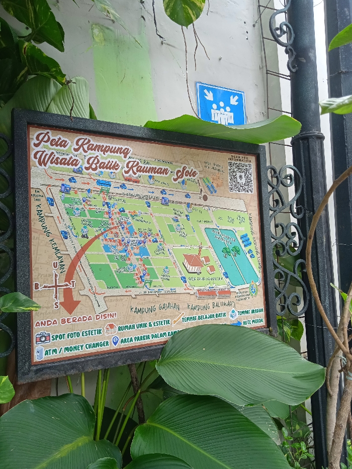
This image captures a weathered informational signboard, set outdoors amidst lush green foliage, against a light-colored wall, part of which is painted light green. The sign is framed in black and prominently displays a map titled "Peta Kampung Wisata Batik Kauman - Solo" (Map of Kauman Batik Tourism Village - Solo).

The map details the layout of the village, showing streets, various buildings, and colored sections, likely indicating different areas or types of establishments. A large red curved arrow on the left points towards the bottom, originating from the "KAMPUNG KEMLAYAN" area, indicating a route. A compass rose with letters B (Barat - West), T (Timur - East), and S (Selatan - South) is visible, with an arrow pointing South.

Below the map, a legend provides symbols for various points of interest:
*   "ANDA BERADA DISINI" (You Are Here)
*   "SPOT FOTO ESTETIK" (Aesthetic Photo Spot)
*   "ATM / MONEY CHANGER"
*   "RUMAH UNIK & ESTETIK" (Unique & Aesthetic House)
*   "AREA PARKIR DALAM KAP" (Parking Area within the Village, possibly a typo for 'kampung')
*   "TEMPAT BELAJAR BATIK" (Batik Learning Place)
*   "TEMPAT IBADAH" (Place of Worship)
*   "RUTE MOTOR" (Motorcycle Route)

Other visible text on the map includes "KAMPUNG GAJAHAN," "KAMPUNG BALUWARTI," and "KAMPUNG KEDUNG LUMBU." A QR code labeled "SCAN FOR INFORMATION" is in the upper right corner of the map.

Above the signboard, on the wall, there's a blue square sign with white stick figures and arrows pointing inwards, typically indicating an assembly point or meeting place. To the right of the signboard, a black ornate metal fence post is visible. The scene suggests a daytime setting in a tourist-oriented area within Surakarta, Indonesia, providing guidance for visitors exploring the batik village.
FM-eHoFi1

Jan 21, 2025, 5:30 AM

Surakarta, Indonesia

Stake attention in this memory

This image captures a weathered informational signboard, set outdoors amidst lush green foliage, against a light-colored wall, part of which is painted light green. The sign is framed in black and prominently displays a map titled "Peta Kampung Wisata Batik Kauman - Solo" (Map of Kauman Batik Tourism Village - Solo). The map details the layout of the village, showing streets, various buildings, and colored sections, likely indicating different areas or types of establishments. A large red curved arrow on the left points towards the bottom, originating from the "KAMPUNG KEMLAYAN" area, indicating a route. A compass rose with letters B (Barat - West), T (Timur - East), and S (Selatan - South) is visible, with an arrow pointing South. Below the map, a legend provides symbols for various points of interest: * "ANDA BERADA DISINI" (You Are Here) * "SPOT FOTO ESTETIK" (Aesthetic Photo Spot) * "ATM / MONEY CHANGER" * "RUMAH UNIK & ESTETIK" (Unique & Aesthetic House) * "AREA PARKIR DALAM KAP" (Parking Area within the Village, possibly a typo for 'kampung') * "TEMPAT BELAJAR BATIK" (Batik Learning Place) * "TEMPAT IBADAH" (Place of Worship) * "RUTE MOTOR" (Motorcycle Route) Other visible text on the map includes "KAMPUNG GAJAHAN," "KAMPUNG BALUWARTI," and "KAMPUNG KEDUNG LUMBU." A QR code labeled "SCAN FOR INFORMATION" is in the upper right corner of the map. Above the signboard, on the wall, there's a blue square sign with white stick figures and arrows pointing inwards, typically indicating an assembly point or meeting place. To the right of the signboard, a black ornate metal fence post is visible. The scene suggests a daytime setting in a tourist-oriented area within Surakarta, Indonesia, providing guidance for visitors exploring the batik village.

Loading AttnAds…

transactions
revenues
stakers
Earliest
Latest
Highest stake

No transactions found

More from this user

More from Surakarta

FM-eHoFi1

Jan 21, 2025, 5:30 AM

Surakarta, Indonesia

Licensed under Creative Commons Attribution 4.0 International License. You are free to share and adapt this content with proper attribution.