Sign in
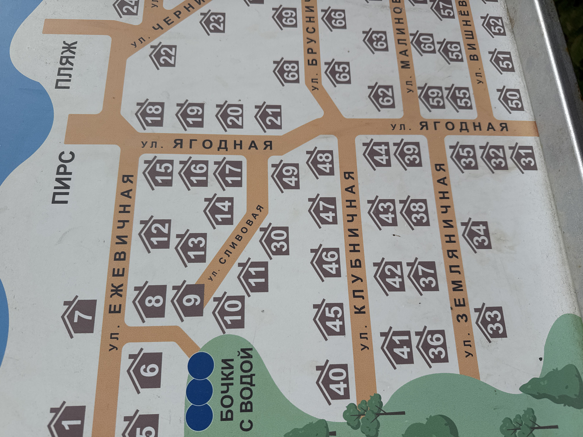
The image displays a map of a suburban settlement or garden association. The map is oriented with the top edge featuring text indicating "ПИРС" (Pier) and "ПЛЯЖ" (Beach). A road labeled "ул. ЕЖЕВИЧНАЯ" (Blackberry Street) runs horizontally across the upper portion of the map, with houses numbered 1 through 13 indicated along its sides. Another road, "ул. СЛИВОВАЯ" (Plum Street), intersects Blackberry Street. Further down, "ул. КЛУБНИЧНАЯ" (Strawberry Street) is depicted, with houses numbered 40 through 49. Below Strawberry Street, "ул. ЗЕМЛЯНИЧНАЯ" (Strawberry Street, but a different spelling and likely a different street) is shown with houses numbered 30 through 37. In the right portion of the map, roads like "ул. ЧЕРНИЧНАЯ" (Blueberry Street) and "ул. БРУСНИЧНАЯ" (Lingonberry Street) are visible, with houses numbered in the 20s, 60s, and 70s. The bottom right of the map shows "ул. ВИШНЁВАЯ" (Cherry Street) with houses numbered in the 50s. There are also labels for "БОЧКИ С ВОДОЙ" (Barrels with water) on the left side, accompanied by three blue circles. The overall environment appears to be a map for residents of a settlement with streets named after berries and common recreational areas like a pier and beach. The location within Tarulinna, Russia, is not explicitly stated on the map itself.
Mashylia

Aug 8, 2026, 11:44 AM

Tarulinna, Russia

Stake attention in this memory

organized
informative
simple
functional
clear

The image displays a map of a suburban settlement or garden association. The map is oriented with the top edge featuring text indicating "ПИРС" (Pier) and "ПЛЯЖ" (Beach). A road labeled "ул. ЕЖЕВИЧНАЯ" (Blackberry Street) runs horizontally across the upper portion of the map, with houses numbered 1 through 13 indicated along its sides. Another road, "ул. СЛИВОВАЯ" (Plum Street), intersects Blackberry Street. Further down, "ул. КЛУБНИЧНАЯ" (Strawberry Street) is depicted, with houses numbered 40 through 49. Below Strawberry Street, "ул. ЗЕМЛЯНИЧНАЯ" (Strawberry Street, but a different spelling and likely a different street) is shown with houses numbered 30 through 37. In the right portion of the map, roads like "ул. ЧЕРНИЧНАЯ" (Blueberry Street) and "ул. БРУСНИЧНАЯ" (Lingonberry Street) are visible, with houses numbered in the 20s, 60s, and 70s. The bottom right of the map shows "ул. ВИШНЁВАЯ" (Cherry Street) with houses numbered in the 50s. There are also labels for "БОЧКИ С ВОДОЙ" (Barrels with water) on the left side, accompanied by three blue circles. The overall environment appears to be a map for residents of a settlement with streets named after berries and common recreational areas like a pier and beach. The location within Tarulinna, Russia, is not explicitly stated on the map itself.

Loading AttnAds…

transactions
revenues
stakers
Earliest
Latest
Highest stake

No transactions found

More from this user

More from Tarulinna

Mashylia

Aug 8, 2026, 11:44 AM

Tarulinna, Russia

Licensed under Creative Commons Attribution 4.0 International License. You are free to share and adapt this content with proper attribution.