
Sign in
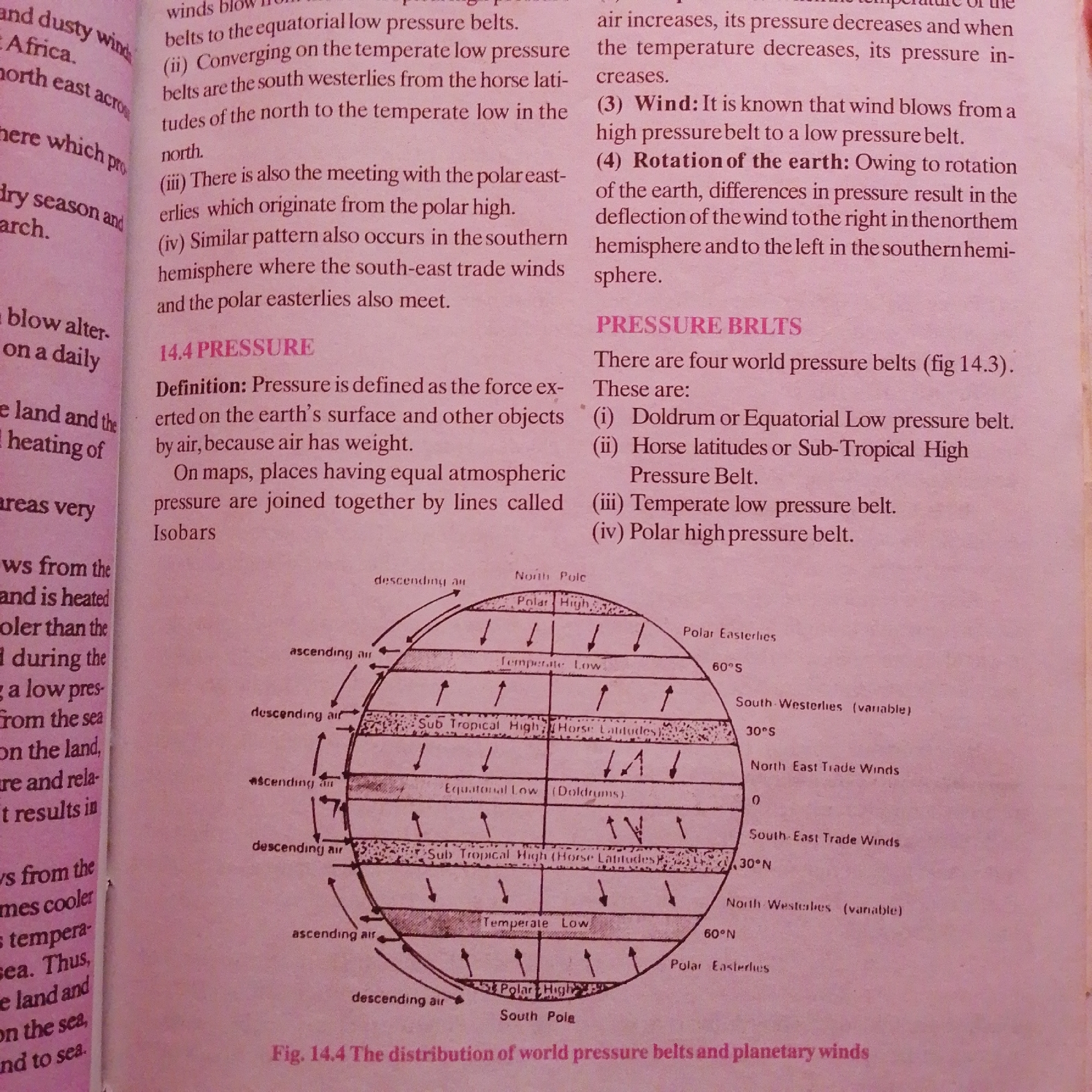
The image is a page from a textbook, likely a geography or science publication, featuring text and a diagram. The text discusses atmospheric pressure, wind belts, and the Earth's rotation. Specific terms like "equatorial low pressure belts," "temperate low pressure," "polar high pressure," and "trade winds" are visible. There are also descriptions of wind patterns and definitions related to pressure.

The prominent visual element is a diagram illustrating the Earth's pressure belts and planetary winds. This diagram depicts the Northern and Southern Hemispheres, with labels indicating different pressure zones such as "Polar High," "Temperate Low," "Sub Tropical High (Horse Latitudes)," and "Equatorial Low (Doldrums)." Arrows show ascending and descending air currents, and wind directions like "Polar Easterlies," "South-Westerlies," "North East Trade Winds," and "South-East Trade Winds" are indicated. Latitude lines (0°, 30°N, 30°S, 60°N, 60°S) are marked, and the North and South Poles are identified.

The overall setting is educational, with the purpose of explaining meteorological concepts. There are no people, animals, or specific time-of-day or weather indicators beyond what is represented in the scientific diagram. The page appears to be from a book with a pinkish background, possibly due to the lighting or the paper's color. The visible text is entirely in English. The location context of Jalingo, Nigeria, is not directly evident from the image itself but is provided as external information.
FM-66btC3

Jun 30, 2026, 4:09 PM

Jalingo, Nigeria

Moment

Stake attention in this memory

informative
educational
scientific
diagrammatic
explanatory

The image is a page from a textbook, likely a geography or science publication, featuring text and a diagram. The text discusses atmospheric pressure, wind belts, and the Earth's rotation. Specific terms like "equatorial low pressure belts," "temperate low pressure," "polar high pressure," and "trade winds" are visible. There are also descriptions of wind patterns and definitions related to pressure. The prominent visual element is a diagram illustrating the Earth's pressure belts and planetary winds. This diagram depicts the Northern and Southern Hemispheres, with labels indicating different pressure zones such as "Polar High," "Temperate Low," "Sub Tropical High (Horse Latitudes)," and "Equatorial Low (Doldrums)." Arrows show ascending and descending air currents, and wind directions like "Polar Easterlies," "South-Westerlies," "North East Trade Winds," and "South-East Trade Winds" are indicated. Latitude lines (0°, 30°N, 30°S, 60°N, 60°S) are marked, and the North and South Poles are identified. The overall setting is educational, with the purpose of explaining meteorological concepts. There are no people, animals, or specific time-of-day or weather indicators beyond what is represented in the scientific diagram. The page appears to be from a book with a pinkish background, possibly due to the lighting or the paper's color. The visible text is entirely in English. The location context of Jalingo, Nigeria, is not directly evident from the image itself but is provided as external information.

Symbol

46A4B

Volume

2,760

Creator

+$0.00

Revenue

+$0.00

TVL

$0.20

1D
1W
1M
All

Loading AttnAds…

transactions
revenues
stakers
Earliest
Latest
Highest stake

1

FM-mmBz23

Staked 1mo ago

$0.20 USD

+$0.00 USD

+0.6%

2

Rev Bot 🤖💰

Injected revenue 1mo ago

Revenue bonus for the last stake.

+$0.00 USD

More from this user

More from Jalingo

FM-66btC3

Jun 30, 2026, 4:09 PM

Jalingo, Nigeria

Licensed under Creative Commons Attribution 4.0 International License. You are free to share and adapt this content with proper attribution.