
Sign in
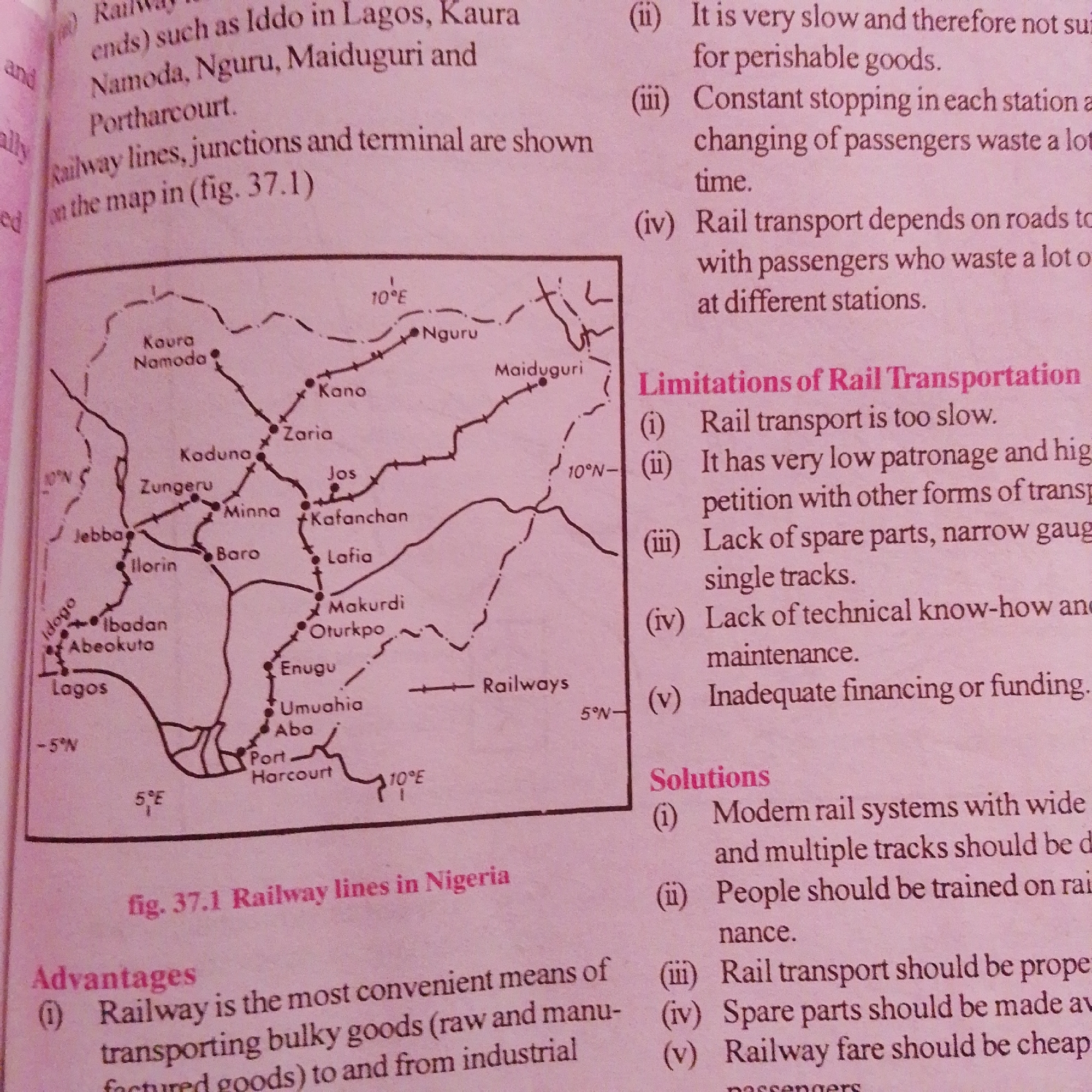
The image displays a page from a textbook or educational material. The primary visual element is a map of "Railway lines in Nigeria" labeled as "fig. 37.1". The map depicts various railway routes connecting cities and towns across Nigeria, including Lagos, Ibadan, Abeokuta, Port Harcourt, Enugu, Makurdi, Jos, Kaduna, Kano, Maiduguri, and others. Latitude and longitude lines are faintly visible.

To the right of the map, there are three distinct sections of text:

1.  **Unlabeled list of points (ii, iii, iv):** These points describe aspects of rail transport, such as its slowness, the issue of stopping at stations, and dependence on roads.
2.  **"Limitations of Rail Transportation":** This section lists five limitations of rail transport, numbered (i) through (v). These include the slowness of rail transport, low patronage, lack of spare parts and narrow gauge single tracks, lack of technical know-how and maintenance, and inadequate financing or funding.
3.  **"Solutions":** This section, numbered (i) through (v), offers potential solutions for rail transport. These include developing modern rail systems with wide and multiple tracks, training people on maintenance, proper upkeep of rail transport, availability of spare parts, and making railway fares cheaper.
4.  **"Advantages":** This section, numbered (i), describes an advantage of railway transport, stating it is the most convenient means of transporting bulky goods and from industrial areas.

The text refers to the city of Jalingo, Nigeria, in the context of railway lines, but Jalingo itself is not explicitly marked on the provided map. The provided map shows railway lines connecting other major Nigerian cities.
FM-66btC3

Jun 30, 2026, 4:20 PM

Jalingo, Nigeria

Moment

Stake attention in this memory

informative
educational
analytical
practical
historical

The image displays a page from a textbook or educational material. The primary visual element is a map of "Railway lines in Nigeria" labeled as "fig. 37.1". The map depicts various railway routes connecting cities and towns across Nigeria, including Lagos, Ibadan, Abeokuta, Port Harcourt, Enugu, Makurdi, Jos, Kaduna, Kano, Maiduguri, and others. Latitude and longitude lines are faintly visible. To the right of the map, there are three distinct sections of text: 1. **Unlabeled list of points (ii, iii, iv):** These points describe aspects of rail transport, such as its slowness, the issue of stopping at stations, and dependence on roads. 2. **"Limitations of Rail Transportation":** This section lists five limitations of rail transport, numbered (i) through (v). These include the slowness of rail transport, low patronage, lack of spare parts and narrow gauge single tracks, lack of technical know-how and maintenance, and inadequate financing or funding. 3. **"Solutions":** This section, numbered (i) through (v), offers potential solutions for rail transport. These include developing modern rail systems with wide and multiple tracks, training people on maintenance, proper upkeep of rail transport, availability of spare parts, and making railway fares cheaper. 4. **"Advantages":** This section, numbered (i), describes an advantage of railway transport, stating it is the most convenient means of transporting bulky goods and from industrial areas. The text refers to the city of Jalingo, Nigeria, in the context of railway lines, but Jalingo itself is not explicitly marked on the provided map. The provided map shows railway lines connecting other major Nigerian cities.

Symbol

48CB7

Volume

4,022

Creator

+$0.00

Revenue

+$0.01

TVL

$0.37

1D
1W
1M
All

Loading AttnAds…

transactions
revenues
stakers
Earliest
Latest
Highest stake

1

FM-mmBz23

Staked 1mo ago

$0.37 USD

+$0.00 USD

+1%

2

Rev Bot 🤖💰

Injected revenue 1mo ago

Revenue bonus for the last stake.

+$0.01 USD

More from this user

More from Jalingo

FM-66btC3

Jun 30, 2026, 4:20 PM

Jalingo, Nigeria

Licensed under Creative Commons Attribution 4.0 International License. You are free to share and adapt this content with proper attribution.