Stake attention in this memory
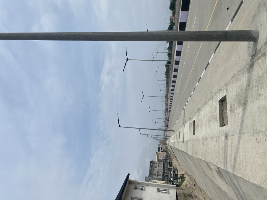
This forensic description details a newly constructed or extensively renovated multi-lane roadway and adjacent concrete infrastructure in Alaguntan, Nigeria, under a partially cloudy sky. **Scene Overview:** The image presents an expansive view of a modern urban infrastructure project, dominated by a wide, empty road and an elevated concrete walkway. **Roadway Details:** The main subject is a multi-lane road, appearing to accommodate at least four lanes (two in each direction), with a smooth, dark grey paved surface. Lane demarcation consists of solid white lines at the shoulders, dashed white lines between lanes, and a solid yellow line along the inner lane boundary. A raised concrete median, painted with alternating black and white rectangular blocks, separates the opposing traffic flows. A long series of uniform, tall, grey poles with dark, flat, T-shaped LED streetlights are consistently spaced along both sides of the road and within the median, extending into the distant horizon. No vehicles are present on the visible road sections, though a large yellow construction vehicle is faintly discernible in the far distance on the right side of the road. **Walkway/Embankment Details:** To the left of the roadway, an elevated, wide, grey concrete pedestrian walkway or embankment runs parallel. This walkway features several rectangular, open depressions or cutouts in its surface, possibly intended for future utilities or landscaping. The concrete structure slopes downwards to the immediate left. **Left Environment (Urban Area):** Immediately adjacent to the sloped concrete structure on the left stands a multi-story building with light-colored, possibly white, exterior walls and multiple rectangular windows. Further down this urban edge, additional buildings of varying heights and finishes are visible. A small, cluttered area at the base of the embankment near these buildings shows indistinct shapes that could be temporary structures or market stalls, with faint indications of small human figures. **Right Environment (Undeveloped/Construction Area):** Beyond the roadway on the right, the land appears flatter and less developed, showing signs of recent clearing or ongoing construction, with sparse vegetation. More streetlights are visible extending into the far distance. **Sky:** The sky is partially overcast, exhibiting patches of light blue intermixed with scattered white and light grey clouds. **People/Actions:** No identifiable individuals are present in the foreground or midground, and no specific actions or interactions are discernible, reinforcing the impression of a recently completed or deserted infrastructure site.
Loading AttnAds…
No transactions found