
Sign in
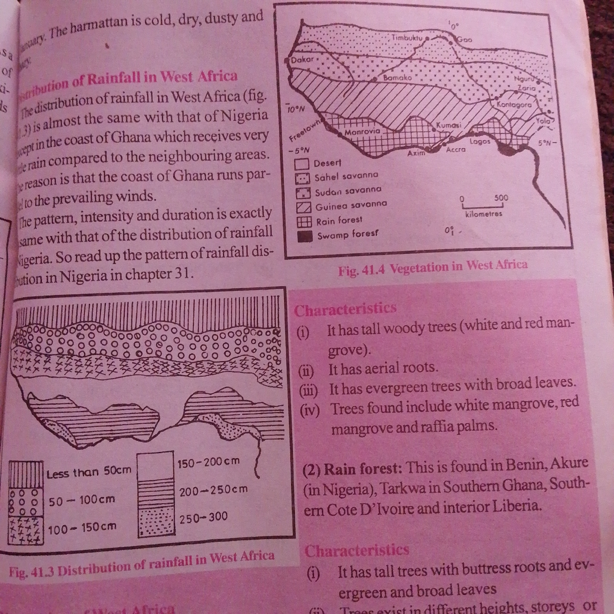
The image contains two diagrams. The first diagram, labeled "Fig. 41.3 Distribution of rainfall in West Africa," is a map of West Africa showing different rainfall zones represented by various patterns and colors. It also includes a legend indicating rainfall amounts in centimeters (Less than 50cm, 50-100cm, 100-150cm, 150-200cm, 200-250cm, 250-300cm). The second diagram, labeled "Fig. 41.4 Vegetation in West Africa," is another map of West Africa illustrating different vegetation zones with corresponding patterns and a legend for types of vegetation (Desert, Sahel savanna, Sudan savanna, Guinea savanna, Rain forest, Swamp forest). Below the second map, there is a section titled "Characteristics" which lists features of the vegetation, including tall woody trees, aerial roots, evergreen trees with broad leaves, white mangrove, red mangrove, and raffia palms. There is also a description of "Rain forest" and its locations in Benin, Akure, Tarkwa, Southern Ghana, South-eastern Cote D'Ivoire, and interior Liberia. The image does not contain any information or depictions related to the city of Jalingo, Nigeria, nor does it show any people, actions, or interactions.
FM-66btC3

Jun 30, 2026, 4:22 PM

Jalingo, Nigeria

Moment

Stake attention in this memory

educational
informative
geographical
analytical
descriptive

The image contains two diagrams. The first diagram, labeled "Fig. 41.3 Distribution of rainfall in West Africa," is a map of West Africa showing different rainfall zones represented by various patterns and colors. It also includes a legend indicating rainfall amounts in centimeters (Less than 50cm, 50-100cm, 100-150cm, 150-200cm, 200-250cm, 250-300cm). The second diagram, labeled "Fig. 41.4 Vegetation in West Africa," is another map of West Africa illustrating different vegetation zones with corresponding patterns and a legend for types of vegetation (Desert, Sahel savanna, Sudan savanna, Guinea savanna, Rain forest, Swamp forest). Below the second map, there is a section titled "Characteristics" which lists features of the vegetation, including tall woody trees, aerial roots, evergreen trees with broad leaves, white mangrove, red mangrove, and raffia palms. There is also a description of "Rain forest" and its locations in Benin, Akure, Tarkwa, Southern Ghana, South-eastern Cote D'Ivoire, and interior Liberia. The image does not contain any information or depictions related to the city of Jalingo, Nigeria, nor does it show any people, actions, or interactions.

Symbol

4AC0C

Volume

7,215

Creator

+$0.01

Revenue

+$0.03

TVL

$1.09

1D
1W
1M
All

Loading AttnAds…

transactions
revenues
stakers
Earliest
Latest
Highest stake

1

FM-mmBz23

Staked 1mo ago

$1.08 USD

+$0.02 USD

+2%

2

Rev Bot 🤖💰

Injected revenue 1mo ago

Revenue bonus for the last stake.

+$0.03 USD

More from this user

More from Jalingo

FM-66btC3

Jun 30, 2026, 4:22 PM

Jalingo, Nigeria

Licensed under Creative Commons Attribution 4.0 International License. You are free to share and adapt this content with proper attribution.