Sign in
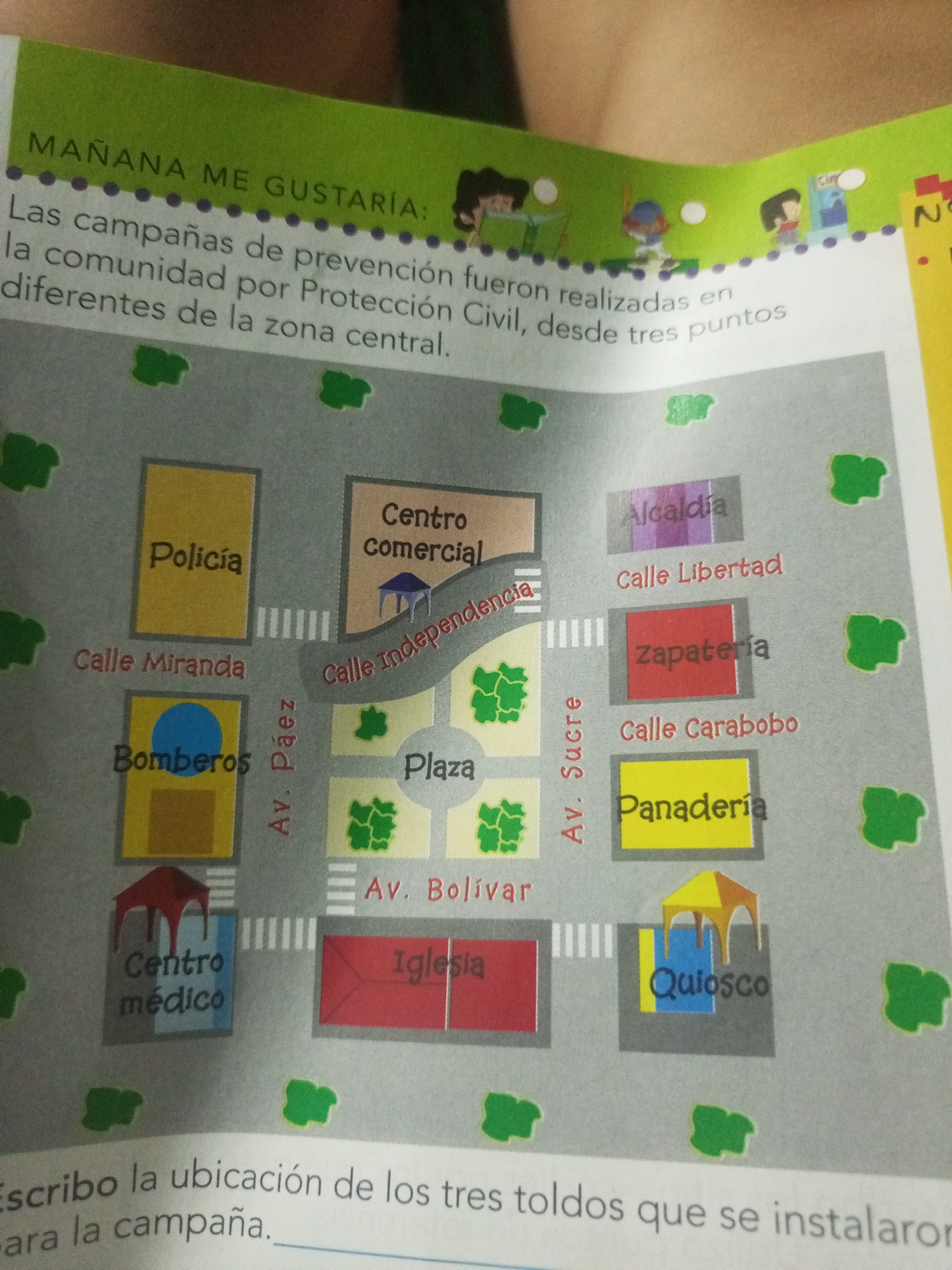
The image is a diagram of a city block with various buildings and streets labeled. The text at the top reads "MAÑANA ME GUSTARÍA: Las campañas de prevención fueron realizadas en la comunidad por Protección Civil, desde tres puntos diferentes de la zona central." which translates to "TOMORROW I WOULD LIKE: The prevention campaigns were carried out in the community by Civil Protection, from three different points in the central area."

The diagram shows the following locations:

*   **Policía** (Police) on Calle Miranda.
*   **Bomberos** (Firefighters) on Calle Miranda.
*   **Centro médico** (Medical center) located south of Bomberos.
*   **Centro comercial** (Shopping center) on Calle Independencia.
*   **Plaza** (Square) east of Calle Independencia and north of Av. Bolívar.
*   **Iglesia** (Church) east of the Plaza.
*   **Alcaldía** (City Hall) on Calle Libertad.
*   **Zapatería** (Shoe store) on Calle Carabobo.
*   **Panadería** (Bakery) south of Zapatería on Calle Carabobo.
*   **Quiosco** (Kiosk) east of Panadería and south of Calle Carabobo.

The streets are labeled as: Calle Miranda, Av. Páez, Calle Independencia, Av. Sucre, Calle Libertad, Calle Carabobo, and Av. Bolívar. The diagram also includes trees and crosswalks. The text at the bottom reads "Escribo la ubicación de los tres toldos que se instalaron para la campaña." which translates to "I am writing the location of the three tents that were set up for the campaign."

The image does not explicitly mention "La Tagua, Venezuela," but it presents a localized urban map with Spanish labels, suggesting a setting where Spanish is the primary language.
Alam Rodríguez

Jun 20, 2026, 2:09 AM

La Tagua, Venezuela

Short Term

Stake attention in this memory

informative
educational
community
civic
planning

The image is a diagram of a city block with various buildings and streets labeled. The text at the top reads "MAÑANA ME GUSTARÍA: Las campañas de prevención fueron realizadas en la comunidad por Protección Civil, desde tres puntos diferentes de la zona central." which translates to "TOMORROW I WOULD LIKE: The prevention campaigns were carried out in the community by Civil Protection, from three different points in the central area." The diagram shows the following locations: * **Policía** (Police) on Calle Miranda. * **Bomberos** (Firefighters) on Calle Miranda. * **Centro médico** (Medical center) located south of Bomberos. * **Centro comercial** (Shopping center) on Calle Independencia. * **Plaza** (Square) east of Calle Independencia and north of Av. Bolívar. * **Iglesia** (Church) east of the Plaza. * **Alcaldía** (City Hall) on Calle Libertad. * **Zapatería** (Shoe store) on Calle Carabobo. * **Panadería** (Bakery) south of Zapatería on Calle Carabobo. * **Quiosco** (Kiosk) east of Panadería and south of Calle Carabobo. The streets are labeled as: Calle Miranda, Av. Páez, Calle Independencia, Av. Sucre, Calle Libertad, Calle Carabobo, and Av. Bolívar. The diagram also includes trees and crosswalks. The text at the bottom reads "Escribo la ubicación de los tres toldos que se instalaron para la campaña." which translates to "I am writing the location of the three tents that were set up for the campaign." The image does not explicitly mention "La Tagua, Venezuela," but it presents a localized urban map with Spanish labels, suggesting a setting where Spanish is the primary language.

Symbol

4F58B

Volume

11,550

Creator

+$0.03

Revenue

+$0.05

TVL

$2.71

1D
1W
1M
All

Loading AttnAds…

transactions
revenues
stakers
Earliest
Latest
Highest stake

1

cruzaleja

Staked 23d ago

$2.69 USD

+$0.02 USD

+0.8%

2

Rev Bot 🤖💰

Injected revenue 23d ago

Revenue bonus for the last stake.

+$0.05 USD

More from this user

More from La Tagua

Alam Rodríguez

Jun 20, 2026, 2:09 AM

La Tagua, Venezuela

Licensed under Creative Commons Attribution 4.0 International License. You are free to share and adapt this content with proper attribution.