
Sign in
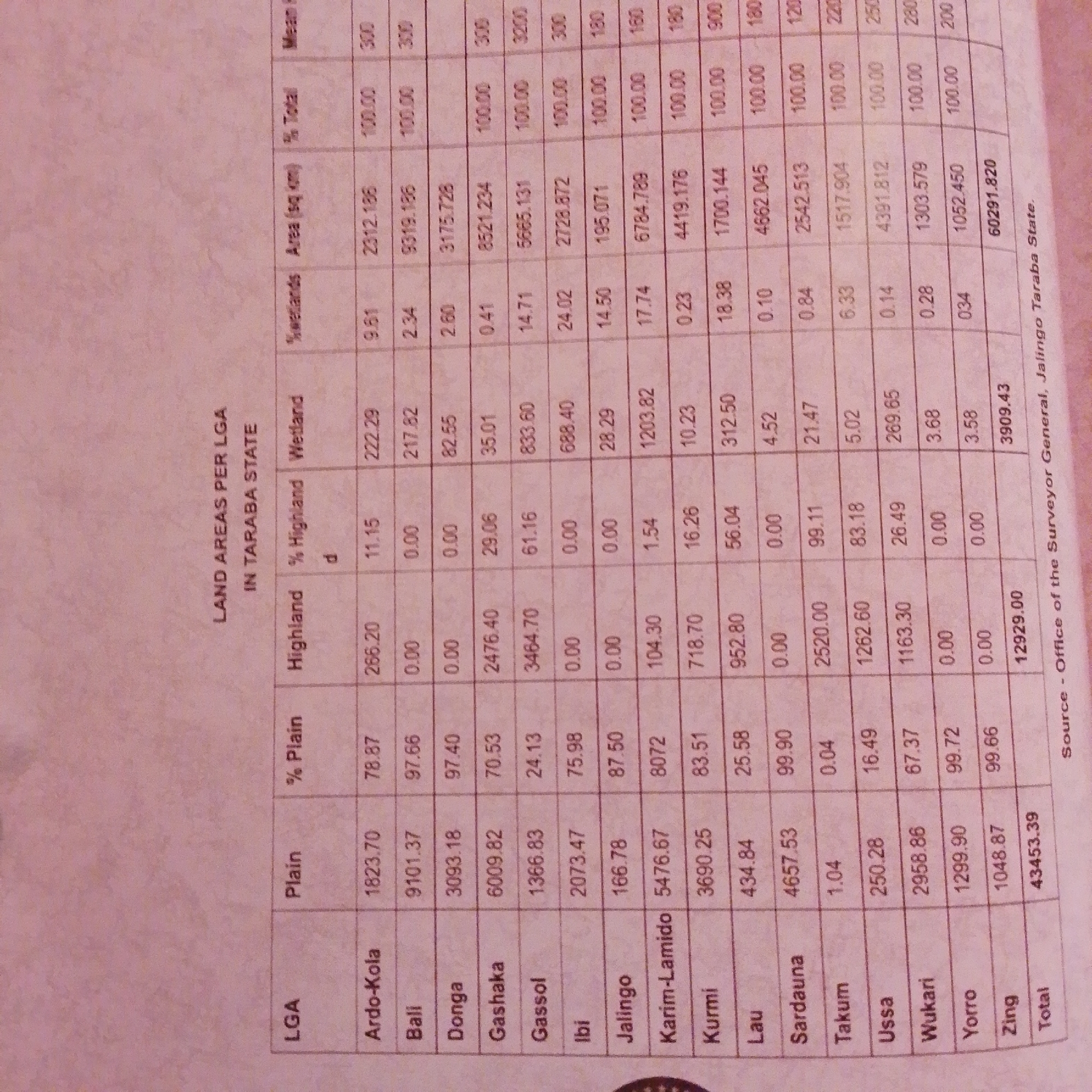
The image is a close-up, slightly angled photograph of a document that appears to be a statistical report or a table. The document contains a significant amount of text and numbers organized into columns and rows, suggesting data related to land areas.

The main heading at the top reads "LAND AREAS PER LGA IN TARABA STATE," indicating the report's focus on local government areas within Taraba State, Nigeria. Below this, a table lists various LGAs, such as "Ardo-Kola," "Bali," "Donga," "Gashaka," and many others, down to "Zing."

The table has several columns, including "LGA," "Plain," "% Plain," "Highland," "% Highland," "Wetland," "%wetlands," "Area (sq km)," "% Total," and "Mean." The numbers in these columns represent measurements and percentages related to different land types within each LGA. For example, "Ardo-Kola" has "1823.70" sq km of plain land, which is 78.87% of its total area, and "266.20" sq km of highland, making up 11.15%.

At the bottom of the table, a "Total" row sums up the figures, showing "43453.39" in the "Plain" column and "12929.00" in the "Area (sq km)" column, along with a total of "3909.43" in the "%wetlands" column.

At the very bottom, a "Source" line provides attribution: "Source - Office of the Surveyor General, Jalingo Taraba State."

The lighting in the image suggests it was taken indoors, possibly with ambient room light. The document itself is printed on white paper, with black text. The overall impression is a professional, data-driven document. There are no people or specific scenes depicted, only the content of the report.
FM-66btC3

Jun 30, 2026, 3:16 PM

Jalingo, Nigeria

Moment

Stake attention in this memory

informative
data-driven
analytical
organized
neutral

The image is a close-up, slightly angled photograph of a document that appears to be a statistical report or a table. The document contains a significant amount of text and numbers organized into columns and rows, suggesting data related to land areas. The main heading at the top reads "LAND AREAS PER LGA IN TARABA STATE," indicating the report's focus on local government areas within Taraba State, Nigeria. Below this, a table lists various LGAs, such as "Ardo-Kola," "Bali," "Donga," "Gashaka," and many others, down to "Zing." The table has several columns, including "LGA," "Plain," "% Plain," "Highland," "% Highland," "Wetland," "%wetlands," "Area (sq km)," "% Total," and "Mean." The numbers in these columns represent measurements and percentages related to different land types within each LGA. For example, "Ardo-Kola" has "1823.70" sq km of plain land, which is 78.87% of its total area, and "266.20" sq km of highland, making up 11.15%. At the bottom of the table, a "Total" row sums up the figures, showing "43453.39" in the "Plain" column and "12929.00" in the "Area (sq km)" column, along with a total of "3909.43" in the "%wetlands" column. At the very bottom, a "Source" line provides attribution: "Source - Office of the Surveyor General, Jalingo Taraba State." The lighting in the image suggests it was taken indoors, possibly with ambient room light. The document itself is printed on white paper, with black text. The overall impression is a professional, data-driven document. There are no people or specific scenes depicted, only the content of the report.

Symbol

529B9

Volume

3,836

Creator

+$0.00

Revenue

+$0.01

TVL

$0.33

1D
1W
1M
All

Loading AttnAds…

transactions
revenues
stakers
Earliest
Latest
Highest stake

1

FM-r1gUH2

Staked 1mo ago

$0.33 USD

+$0.01 USD

+2%

2

Rev Bot 🤖💰

Injected revenue 1mo ago

Revenue bonus for the last stake.

+$0.01 USD

More from this user

More from Jalingo

FM-66btC3

Jun 30, 2026, 3:16 PM

Jalingo, Nigeria

Licensed under Creative Commons Attribution 4.0 International License. You are free to share and adapt this content with proper attribution.