Sign in
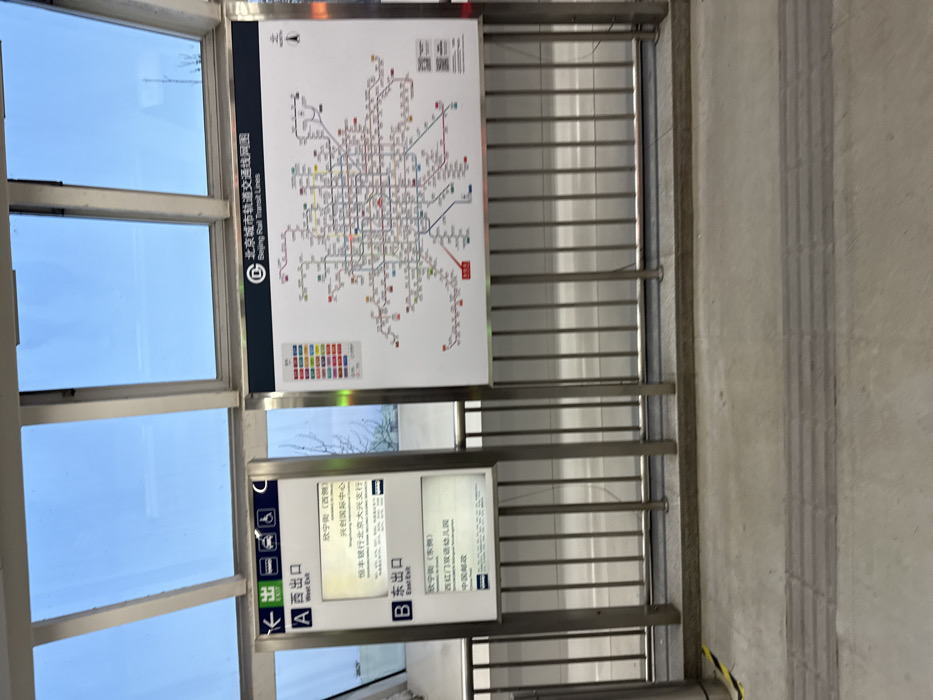
The image captures a functional area within a Beijing rail transit station or overpass, featuring informational signage and modern architecture. The scene is dominated by two signs mounted on metal railings, with large windows to the left revealing a clear, bright sky.

The upper and larger sign displays a comprehensive map titled "北京城市轨道交通线网图" (Beijing City Rail Transit Line Network Map), with the English translation "Beijing Rail Transit Lines." This map details the extensive network of subway lines across Beijing, using various colors to distinguish different routes and showing numerous station stops. A legend for the line colors is visible at the bottom of the map.

Below this map, a smaller sign provides specific exit information. It designates "A 西出口 West Exit," listing destinations such as "太宁街 (西侧)" (Taining Street (West Side)), "兴创国际中心" (Xingchuang International Center), and "恒丰银行北京大兴支行" (Hengfeng Bank Beijing Daxing Branch). Adjacent to this is "B 东出口 East Exit," directing passengers to "太宁街 (东侧)" (Taining Street (East Side)), "西红门双语幼儿园" (Xihongmen Bilingual Kindergarten), and "中国邮政" (China Post). Both exit sections feature universal accessibility symbols, including those for wheelchairs and escalators/elevators.

No people are present in the image. The bright conditions outside the windows suggest it is daytime. The floor is concrete, with a tactile paving strip visible on the right, designed to assist visually impaired individuals. The setting conveys a sense of a clean, organized, and modern public transit environment in Beijing, China.
Laurent

Feb 17, 2025, 9:56 AM

Beijing, China

Stake attention in this memory

The image captures a functional area within a Beijing rail transit station or overpass, featuring informational signage and modern architecture. The scene is dominated by two signs mounted on metal railings, with large windows to the left revealing a clear, bright sky. The upper and larger sign displays a comprehensive map titled "北京城市轨道交通线网图" (Beijing City Rail Transit Line Network Map), with the English translation "Beijing Rail Transit Lines." This map details the extensive network of subway lines across Beijing, using various colors to distinguish different routes and showing numerous station stops. A legend for the line colors is visible at the bottom of the map. Below this map, a smaller sign provides specific exit information. It designates "A 西出口 West Exit," listing destinations such as "太宁街 (西侧)" (Taining Street (West Side)), "兴创国际中心" (Xingchuang International Center), and "恒丰银行北京大兴支行" (Hengfeng Bank Beijing Daxing Branch). Adjacent to this is "B 东出口 East Exit," directing passengers to "太宁街 (东侧)" (Taining Street (East Side)), "西红门双语幼儿园" (Xihongmen Bilingual Kindergarten), and "中国邮政" (China Post). Both exit sections feature universal accessibility symbols, including those for wheelchairs and escalators/elevators. No people are present in the image. The bright conditions outside the windows suggest it is daytime. The floor is concrete, with a tactile paving strip visible on the right, designed to assist visually impaired individuals. The setting conveys a sense of a clean, organized, and modern public transit environment in Beijing, China.

Loading AttnAds…

transactions
revenues
stakers
Earliest
Latest
Highest stake

No transactions found

More from this user

More from Beijing

Laurent

Feb 17, 2025, 9:56 AM

Beijing, China

Licensed under Creative Commons Attribution 4.0 International License. You are free to share and adapt this content with proper attribution.