
Sign in
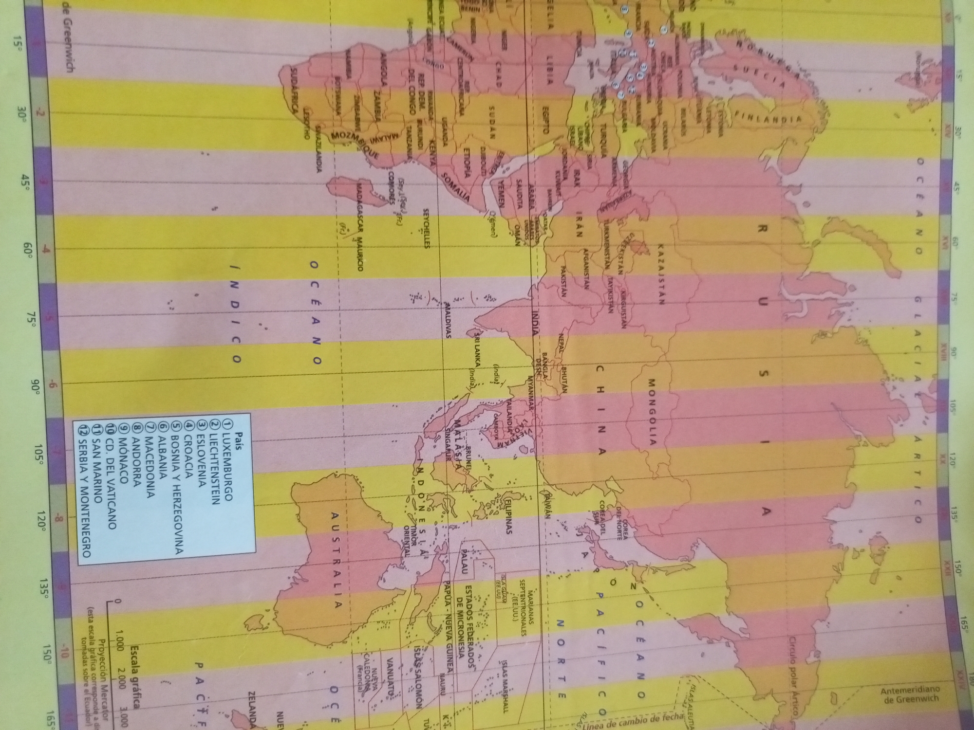
This is a physical map of the world, displayed on a flat surface, likely a wall or a table. The map is richly colored, with distinct zones representing different time zones, indicated by vertical bands of yellow, pink, and purple. Longitude lines are clearly marked along the bottom and right edges, ranging from 0° to 180° in increments of 15°. The map features countries and oceans, with names written in Spanish. Prominent geographical features like continents, islands, and major bodies of water such as the "OCEANO ÍNDICO," "OCEANO PACÍFICO," and "OCEANO ATLANTICO" are labeled.

A key detail is a legend on the left side listing twelve countries with corresponding numbers, likely relating to their time zone or some other classification. These countries include "LUXEMBURGO," "LIECHTENSTEIN," and "CD. DEL VATICANO." A scale bar is also present at the bottom, indicating distances in kilometers for a Mercator projection.

The map is likely in a static display, as there are no people or discernible action. The lighting appears to be even, suggesting an indoor setting with artificial light. The overall impression is one of an educational or informational tool, focused on geographical and temporal divisions of the Earth. The location context "Santa Ana, Venezuela" implies this map is situated within that geographical area. There is no indication of time of day, weather, or emotions due to the absence of people and a dynamic scene.
Ricardo

Jun 23, 2026, 12:13 PM

Santa Ana, Venezuela

Short Term

Stake attention in this memory

curious
analytical
organized
reflective
intellectual

This is a physical map of the world, displayed on a flat surface, likely a wall or a table. The map is richly colored, with distinct zones representing different time zones, indicated by vertical bands of yellow, pink, and purple. Longitude lines are clearly marked along the bottom and right edges, ranging from 0° to 180° in increments of 15°. The map features countries and oceans, with names written in Spanish. Prominent geographical features like continents, islands, and major bodies of water such as the "OCEANO ÍNDICO," "OCEANO PACÍFICO," and "OCEANO ATLANTICO" are labeled. A key detail is a legend on the left side listing twelve countries with corresponding numbers, likely relating to their time zone or some other classification. These countries include "LUXEMBURGO," "LIECHTENSTEIN," and "CD. DEL VATICANO." A scale bar is also present at the bottom, indicating distances in kilometers for a Mercator projection. The map is likely in a static display, as there are no people or discernible action. The lighting appears to be even, suggesting an indoor setting with artificial light. The overall impression is one of an educational or informational tool, focused on geographical and temporal divisions of the Earth. The location context "Santa Ana, Venezuela" implies this map is situated within that geographical area. There is no indication of time of day, weather, or emotions due to the absence of people and a dynamic scene.

Symbol

55A3D

Volume

11,550

Creator

+$0.10

Revenue

+$0.17

TVL

$7.98

1D
1W
1M
All
transactions
revenues
stakers
Earliest
Latest
Highest stake

1

Rafael Jiménez

Staked 11d ago

$7.89 USD

+$0.09 USD

+1%

2

Rev Bot 🤖💰

Injected revenue 11d ago

Revenue bonus for the last stake.

+$0.19 USD

More from this user

More from Santa Ana

Ricardo

Jun 23, 2026, 12:13 PM

Santa Ana, Venezuela

Licensed under Creative Commons Attribution 4.0 International License. You are free to share and adapt this content with proper attribution.