
Sign in
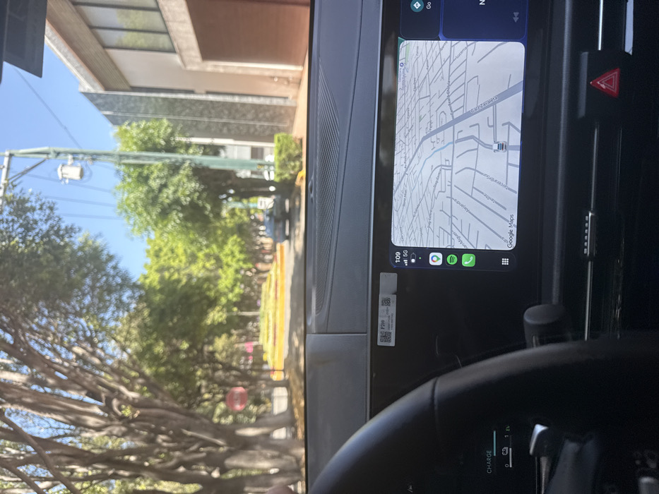
The image depicts an interior view of a vehicle's dashboard looking out onto a street scene in San Bernardino Tlaxcalancingo, Puebla, Mexico, on a clear, sunny day.

The foreground is dominated by the dark-colored dashboard of the vehicle. A black steering wheel is partially visible on the left. Integrated into the dashboard is a large digital display featuring a Google Maps navigation interface. The map shows a grid of streets with identifiable names such as "Calle Monte Pedro," "Calle Tepeyahualco," "Calle San Miguel," "Calle Zacatepec," and "Calle Alejandría," confirming the location in San Bernardino Tlaxcalancingo. The screen also displays the time "1:09," a "5G" cellular indicator, and icons for Apple CarPlay applications including Spotify. To the left of the main display, a partially visible digital gauge cluster shows "CHARGE" and "1 EV." A white sticker with QR codes and the designation "P200" is affixed to the dashboard above the main screen. A red triangular hazard light button is visible below the main display.

Through the windshield, a paved street extends into the distance, bordered by numerous mature trees with green foliage. A raised median with yellow curbing and green vegetation divides the road. On the right side of the street, a multi-story building with a modern facade featuring dark grey textured panels and large windows is visible, alongside a brown garage door. A utility pole equipped with a transformer stands on the right. On the left, a red circular road sign is partially obscured by trees. A dark-colored sedan is parked or driving further down the street on the right. The sky is clear and blue, indicating bright daylight. No individuals are visible in the scene.
valerio

Mar 20, 2026, 7:09 PM

San Bernardino Tlaxcalancingo, Mexico

Stake attention in this memory

Calm
Serenity
Routine
Inquisitive
Wandering

The image depicts an interior view of a vehicle's dashboard looking out onto a street scene in San Bernardino Tlaxcalancingo, Puebla, Mexico, on a clear, sunny day. The foreground is dominated by the dark-colored dashboard of the vehicle. A black steering wheel is partially visible on the left. Integrated into the dashboard is a large digital display featuring a Google Maps navigation interface. The map shows a grid of streets with identifiable names such as "Calle Monte Pedro," "Calle Tepeyahualco," "Calle San Miguel," "Calle Zacatepec," and "Calle Alejandría," confirming the location in San Bernardino Tlaxcalancingo. The screen also displays the time "1:09," a "5G" cellular indicator, and icons for Apple CarPlay applications including Spotify. To the left of the main display, a partially visible digital gauge cluster shows "CHARGE" and "1 EV." A white sticker with QR codes and the designation "P200" is affixed to the dashboard above the main screen. A red triangular hazard light button is visible below the main display. Through the windshield, a paved street extends into the distance, bordered by numerous mature trees with green foliage. A raised median with yellow curbing and green vegetation divides the road. On the right side of the street, a multi-story building with a modern facade featuring dark grey textured panels and large windows is visible, alongside a brown garage door. A utility pole equipped with a transformer stands on the right. On the left, a red circular road sign is partially obscured by trees. A dark-colored sedan is parked or driving further down the street on the right. The sky is clear and blue, indicating bright daylight. No individuals are visible in the scene.

Loading AttnAds…

transactions
revenues
stakers
Earliest
Latest
Highest stake

No transactions found

More from this user

More from San Bernardino Tlaxcalancingo

valerio

Mar 20, 2026, 7:09 PM

San Bernardino Tlaxcalancingo, Mexico

Licensed under Creative Commons Attribution 4.0 International License. You are free to share and adapt this content with proper attribution.