Stake attention in this memory
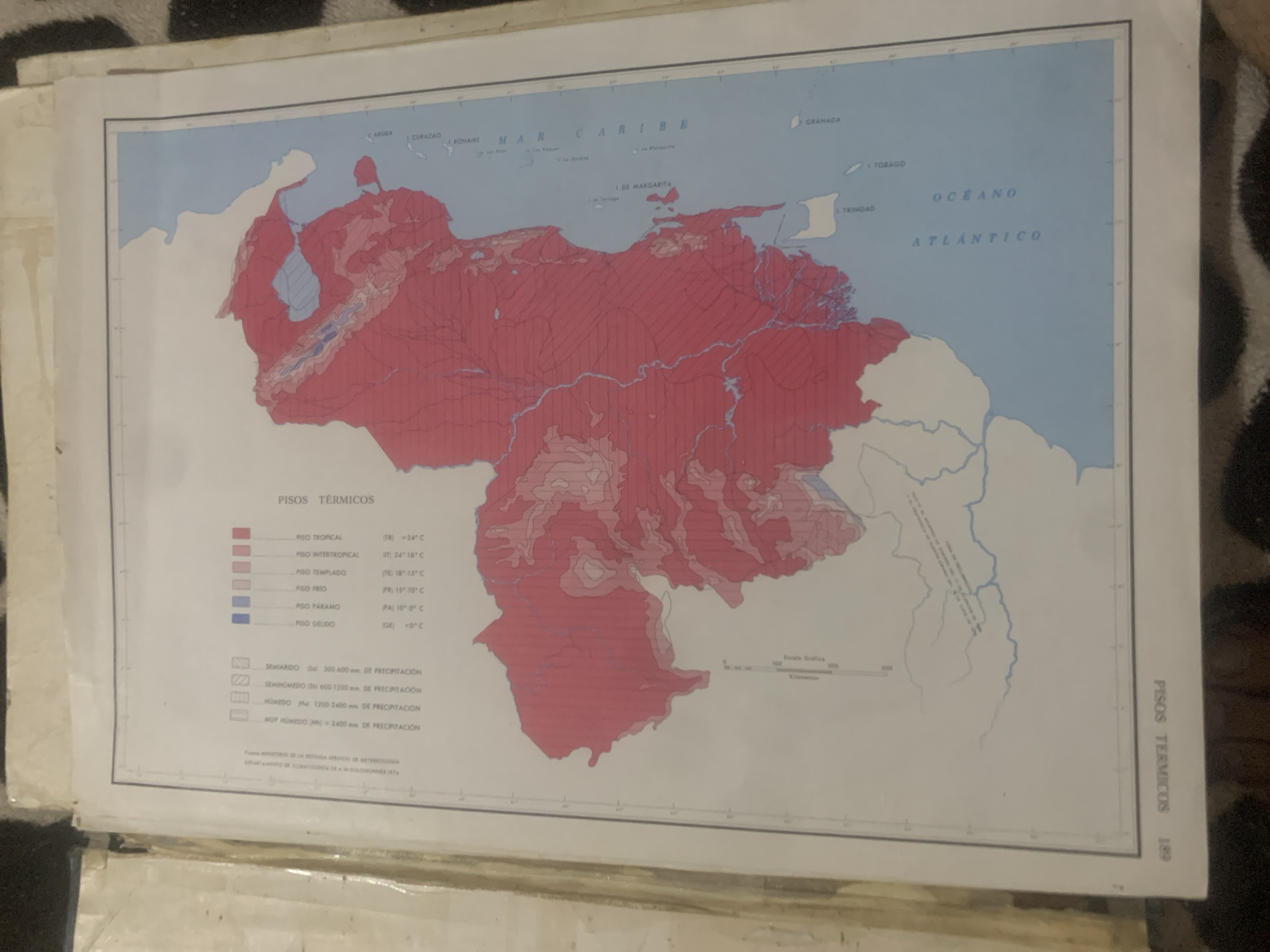
This is an image of a map titled "PISOS TÉRMICOS" (Thermal Floors) which appears to be a climatological map of Venezuela and surrounding Caribbean waters. The map displays different thermal zones represented by color-coded areas and also shows precipitation levels using patterned blocks. The map includes geographical features such as coastlines, islands (Aruba, Curacao, Bonaire, Margarita, Tobago, Trinidad, Grenada), and bodies of water labeled "MAR CARIBE" (Caribbean Sea) and "OCEANO ATLÁNTICO" (Atlantic Ocean). Several locations are marked, including "La Tagua". A legend on the right side of the map explains the thermal zones, listing them as "PISO TROPICAL" (Tropical Floor), "PISO INTERTROPICAL" (Intertropical Floor), "PISO TEMPLADO" (Temperate Floor), "PISO FRÍO" (Cold Floor), "PISO PÁRAMO" (Paramo Floor), and "PISO GÉLIDO" (Gelid Floor), with corresponding temperature ranges. Below this, another legend describes precipitation levels: "SEMIÁRIDO" (Semi-arid), "SEMIHÚMEDO" (Semi-humid), "HÚMEDO" (Humid), and "MUY HÚMEDO" (Very Humid), with associated millimeter ranges. Text at the bottom of the map indicates the source: "FUENTE: MINISTERIO DE LA DEFENSA - SERVICIO DE METEOROLOGÍA - DEPARTAMENTO DE CLIMATOLOGÍA" (Source: Ministry of Defense - Meteorology Service - Climatology Department) and a date of "1974". The image is a photograph of a document, likely a page from an atlas or a report, with some of the paper creased and worn. The lighting suggests it was taken indoors, possibly with a flash, which creates some glare and shadows. There are no people visible in the image. The context "La Tagua, Venezuela" appears to be a label for the geographical location being referenced by the map.
Symbol
6167C
Volume
11,550
Creator
+$0.14
Revenue
+$0.21
TVL
$11.59
2
Rev Bot 🤖💰
Injected revenue 6d ago
“Revenue bonus for the last stake.”
+$0.23 USD


