Stake attention in this memory
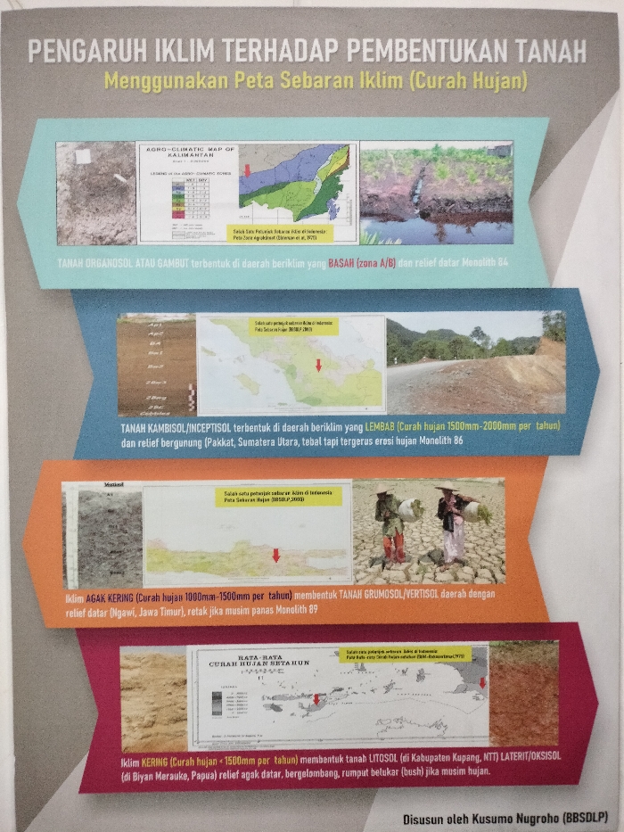
This image is a detailed infographic poster titled "PENGARUH IKLIM TERHADAP PEMBENTUKAN TANAH Menggunakan Peta Sebaran Iklim (Curah Hujan)" (Influence of Climate on Soil Formation Using Climate Distribution Map (Rainfall)). It was compiled by Kusumo Nugroho (BBSDLP), likely presented in Bogor, Indonesia. The poster is divided into four horizontal sections, each illustrating how a different climate type (based on rainfall) leads to specific soil formations in various Indonesian regions. 1. **BASAH (Wet Climate, zone A/B):** Depicted with an "AGRO-CLIMATIC MAP OF KALIMANTAN," a soil profile, and a landscape image of a watery area with lush vegetation. The text states "TANAH ORGANOSOL ATAU GAMBUT" (ORGANOSOL OR PEAT SOIL) forms here, with flat relief. 2. **LEMBAB (Humid Climate, 1500-2000mm/year rainfall):** Illustrated with a soil profile, a map of Indonesia pointing to North Sumatra (Pakkat), and a photo of a road through a mountainous landscape. This climate forms "TANAH KAMBISOL/INCEPTISOL," which can be thick but subject to rain erosion. 3. **AGAK KERING (Moderately Dry Climate, 1000-1500mm/year rainfall):** This section features a soil profile showing cracked earth, a map pointing to East Java (Ngawi), and a poignant image of two individuals, possibly farmers in traditional attire, carrying baskets on their shoulders, walking across severely cracked, dry earth. The text indicates "TANAH GRUMOSOL/VERTISOL" forms here, cracking during the hot season. 4. **KERING (Dry Climate, <1500mm/year rainfall):** Shown with images of reddish-brown soil (laterite/oxisol) and a "RATA-RATA CURAH HUJAN SETAHUN" (Average Annual Rainfall) map of Indonesia, with arrows indicating Kupang, NTT, and Merauke, Papua. This climate forms "TANAH LITOSOL" or "LATERIT/OKSISOL" with slightly flat to undulating relief, with bush growth during the rainy season. The poster uses maps to provide location cues within Indonesia and various soil and landscape photographs to visualize the effects of climate on soil. The cracked earth and the image of people traversing it in the "Moderately Dry" section notably convey the harsh conditions associated with such climates.
No transactions found