Stake attention in this memory
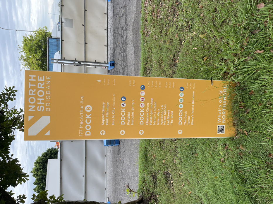
A large, upright, yellow wayfinding sign for "NORTH SHORE BRISBANE" stands outdoors in what appears to be a mixed-use or developing area in Hamilton, Australia. The sign features destinations, estimated walking times, and directional arrows. The top of the sign displays "NORTH SHORE BRISBANE" and "177 MacArthur Ave". Below this, it lists various locations categorized by "DOCK" with associated walking times and icons. **DOCK B** points to: * Superordinary (1 min) * Pink Flamingo (6 min) * Bus to City Theodore St (4 min) **DOCK A** (with a parking icon) points to: * Portside (8 min) * Hercules St Park (8 min) **DOCK C** (with parking, accessible toilet, and possibly dining icons) points to: * Flipside Circus (5 min) * Passenger pickup (5 min) * Maritime Green (6 min) * River Walk (6 min) * Workshops & Maker Spaces (6 min) * Eat Street (8 min) * The Shed (10 min) **DOCK D** (with parking, accessible toilet, and possibly dining icons) points to: * The Deck (time unreadable from OCR, but visible as 11 min on the image) * Tennis (12 min) * Bluey's World Brisbane (12 min) The bottom right corner of the sign shows "What's on @ NORTHSHORE" with a QR code. The setting includes a paved surface in front of the sign, leading to a grassy area on the right. In the background, there are temporary construction barriers or fences, and some green foliage from trees. The sky is overcast, suggesting daytime. The sign's purpose is to guide pedestrians to various points of interest within the North Shore Brisbane precinct.
No transactions found