
Sign in
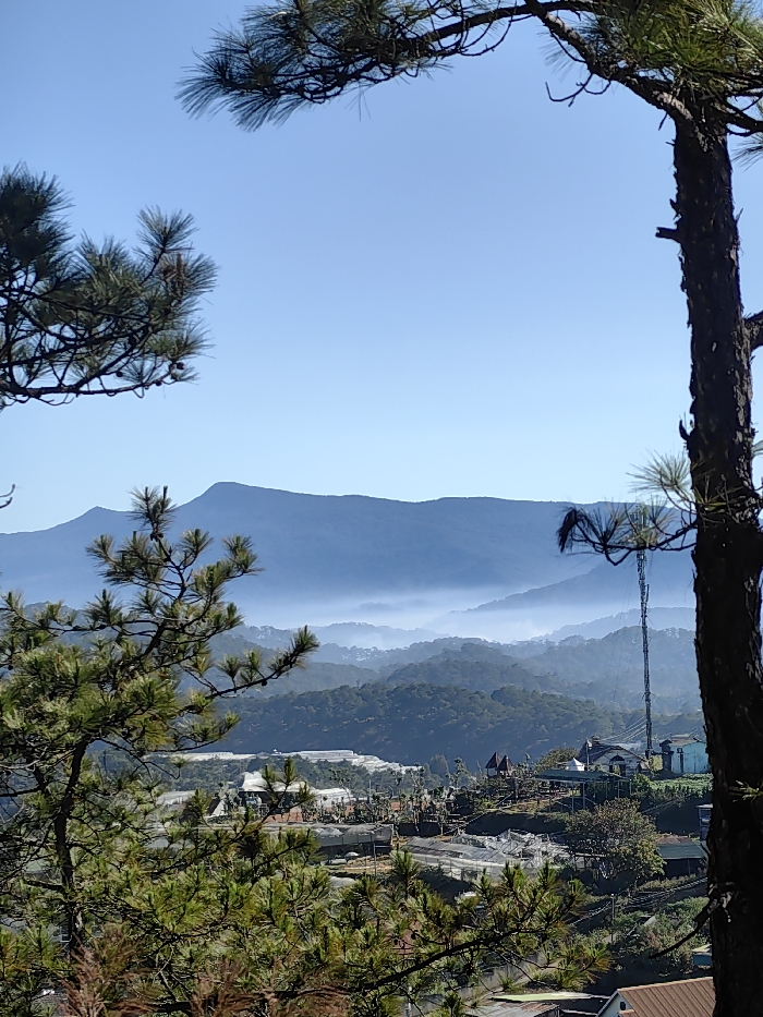
The image captures a panoramic landscape view from a high vantage point, framed by lush green pine trees in the foreground. The sky occupies the upper portion of the frame, a clear and vibrant light blue, devoid of clouds.

In the mid-ground and background, layers of mountains and hills recede into the distance, exhibiting strong atmospheric perspective. The furthest mountain range appears as a dark blue silhouette against the horizon. Below this, a distinct band of white to light blue mist or haze fills the valleys and lower slopes of the hills, creating a soft, ethereal effect and emphasizing the depth of the landscape.

Below the mist line, the terrain slopes downwards into a valley where human habitation and agricultural activity are visible. Numerous green hillsides are covered with dense tree growth. Scattered throughout the valley are houses and buildings, some with reddish-brown roofs and others with lighter tones. A prominent feature in the mid-ground is an extensive area covered by white or translucent tarpaulins, strongly suggesting the presence of greenhouses or plant nurseries, indicating significant agricultural activity in the region.

On the right side of the image, extending upwards from the valley, stands a tall metal communication tower or antenna. Near it, a distinctive structure with a red roof and what appears to be white pillars or supports resembles a gazebo or a small observation deck. The foreground is blurred, but the needles of the pine trees, particularly on the left and right edges, are sharply in focus, providing a natural frame for the expansive view.

The overall impression is one of a serene, misty mountain landscape bathed in clear daylight, likely either early morning or late afternoon, given the atmospheric conditions. No specific activity or visible text is apparent in the photograph.
udm_marishko

Feb 21, 2026, 1:14 AM

Xuân Thành, Vietnam

Stake attention in this memory

landscape
mountains
trees
fog
view

The image captures a panoramic landscape view from a high vantage point, framed by lush green pine trees in the foreground. The sky occupies the upper portion of the frame, a clear and vibrant light blue, devoid of clouds. In the mid-ground and background, layers of mountains and hills recede into the distance, exhibiting strong atmospheric perspective. The furthest mountain range appears as a dark blue silhouette against the horizon. Below this, a distinct band of white to light blue mist or haze fills the valleys and lower slopes of the hills, creating a soft, ethereal effect and emphasizing the depth of the landscape. Below the mist line, the terrain slopes downwards into a valley where human habitation and agricultural activity are visible. Numerous green hillsides are covered with dense tree growth. Scattered throughout the valley are houses and buildings, some with reddish-brown roofs and others with lighter tones. A prominent feature in the mid-ground is an extensive area covered by white or translucent tarpaulins, strongly suggesting the presence of greenhouses or plant nurseries, indicating significant agricultural activity in the region. On the right side of the image, extending upwards from the valley, stands a tall metal communication tower or antenna. Near it, a distinctive structure with a red roof and what appears to be white pillars or supports resembles a gazebo or a small observation deck. The foreground is blurred, but the needles of the pine trees, particularly on the left and right edges, are sharply in focus, providing a natural frame for the expansive view. The overall impression is one of a serene, misty mountain landscape bathed in clear daylight, likely either early morning or late afternoon, given the atmospheric conditions. No specific activity or visible text is apparent in the photograph.

Loading AttnAds…

transactions
revenues
stakers
Earliest
Latest
Highest stake

No transactions found

More from this user

More from Xuân Thành

udm_marishko

Feb 21, 2026, 1:14 AM

Xuân Thành, Vietnam

Licensed under Creative Commons Attribution 4.0 International License. You are free to share and adapt this content with proper attribution.