Stake attention in this memory
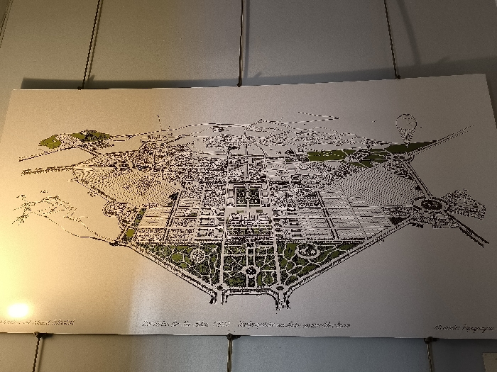
This image captures a detailed urban plan or map, likely a historical or conceptual design for a city. The map is displayed on a light-colored, possibly metallic or laminated surface, hanging on a neutral gray wall, suggesting it's part of an exhibition or museum display. The plan itself depicts a large, complex urban layout with intricate details of streets, buildings, and significant green spaces. A prominent feature is a coastline or waterfront, particularly on the left side, showing a body of water with several small islands or peninsulas and what appears to be a harbor area. The central part of the map exhibits a highly organized, grid-like structure with large rectangular blocks and symmetrical green areas, some featuring circular designs. More green areas are interspersed throughout the urban fabric, indicating parks or planned natural spaces. On the right side, another water body is visible, connected by what could be a bridge or causeway. The image is illuminated by a warm light source from the bottom left, creating a noticeable glare on the map's surface. Black lines define the city's structures and boundaries, while shades of green are used to highlight foliage and parks. Visible text on the bottom edge of the map provides crucial context: - On the bottom left, partially obscured by light, "The idea of the ideal..." is faintly legible. - In the bottom center, clearer text reads: "A plan for the year 1930... Athens and its coastal plain". This indicates the map represents a proposed or envisioned development for Athens, Greece, in 1930. - On the bottom right, the name "Bernard Hoeseges" is visible, likely identifying the designer or artist of the plan. The overall impression is of a meticulously planned urban landscape, reflecting the architectural and city planning ideals of the early 20th century, specifically for Athens.
No transactions found