Stake attention in this memory
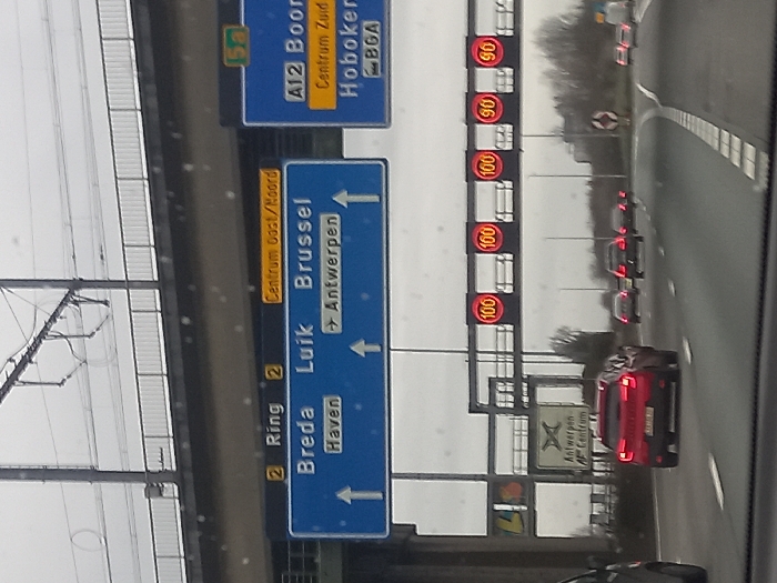
The image depicts a multi-lane highway at the Knooppunt Antwerpen-Zuid (Antwerp South Interchange) on the R1 (Antwerp Ring) in Antwerp, Belgium, under an overcast sky. The road surface appears damp or wet. In the foreground, the view is from inside a vehicle, partially showing the windshield or dashboard. Directly ahead, in the center lane, is a red SUV with illuminated tail lights. Several other vehicles, also with illuminated rear lights, are visible further down the road, indicating ongoing traffic. Overhead, a prominent blue gantry sign displays various destinations: - On the left column, with an upward arrow, "Breda" and "Haven." - In the middle column, with an upward arrow, "Luik" and "Brussel." - On the right column, with an upward arrow, "Antwerpen," and a right-pointing arrow next to "Antwerpen" for an exit. - Above these columns, the sign indicates "2 Ring 2" and "Centrum Oost/Noord." To the right of this main sign, another blue overhead sign indicates "A12 Boom," "Centrum Zuid," "Hoboken," and "BGA" (likely for the Antwerpen-Zuid exit). Further down the road, a separate white square sign with a black border shows "Antwerpen Centrum" accompanied by a crossroads symbol. Above the main traffic lanes, an overhead gantry displays multiple variable message signs showing speed limits: three circular red signs indicating "100" km/h, followed by two circular red signs indicating "90" km/h. Above the entire scene, an elevated concrete bridge or viaduct with white metal railings spans the highway. Overhead catenary wires for a railway line are visible above this bridge, suggesting a railway track runs across the overpass. The distant horizon shows sparse trees and vegetation against the gray sky. No pedestrians or specific incidents are observable.
No transactions found