Sign in
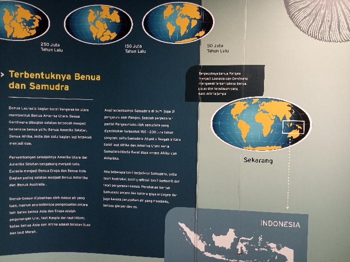
The image shows an informational display in the Museum Zoologi Bogor (Bogor Zoo), located at the coordinates -6.599, 106.794, in Bogor, Indonesia. The display depicts the formation of continents and oceans over millions of years. There are three diagrams illustrating the Earth's configuration 250 million, 150 million, and 50 million years ago, respectively. Each diagram shows the continents as separate landmasses, gradually merging into a supercontinent called Pangaea, and then slowly drifting apart to form the current configuration. The main text in Indonesian explains the process of continental drift and the formation of oceans. The text also mentions the theories about the formation of the Samudra (ocean). The display features an oval-shaped diagram of the world as it is now, with a highlighted rectangular area indicating the location of Indonesia. The bottom of the display shows a map of Indonesia in pink, indicating the country's location in Southeast Asia. The image shows an educational exhibit designed to teach visitors about the geological history of the Earth.
FM-DWNFF3

Apr 9, 2025, 3:44 AM

Bogor, Indonesia

Stake attention in this memory

informative
educational
historical
scientific
geographical

The image shows an informational display in the Museum Zoologi Bogor (Bogor Zoo), located at the coordinates -6.599, 106.794, in Bogor, Indonesia. The display depicts the formation of continents and oceans over millions of years. There are three diagrams illustrating the Earth's configuration 250 million, 150 million, and 50 million years ago, respectively. Each diagram shows the continents as separate landmasses, gradually merging into a supercontinent called Pangaea, and then slowly drifting apart to form the current configuration. The main text in Indonesian explains the process of continental drift and the formation of oceans. The text also mentions the theories about the formation of the Samudra (ocean). The display features an oval-shaped diagram of the world as it is now, with a highlighted rectangular area indicating the location of Indonesia. The bottom of the display shows a map of Indonesia in pink, indicating the country's location in Southeast Asia. The image shows an educational exhibit designed to teach visitors about the geological history of the Earth.

Loading AttnAds…

transactions
revenues
stakers
Earliest
Latest
Highest stake

No transactions found

More from this user

More from Bogor

FM-DWNFF3

Apr 9, 2025, 3:44 AM

Bogor, Indonesia

Licensed under Creative Commons Attribution 4.0 International License. You are free to share and adapt this content with proper attribution.