
Stake attention in this memory
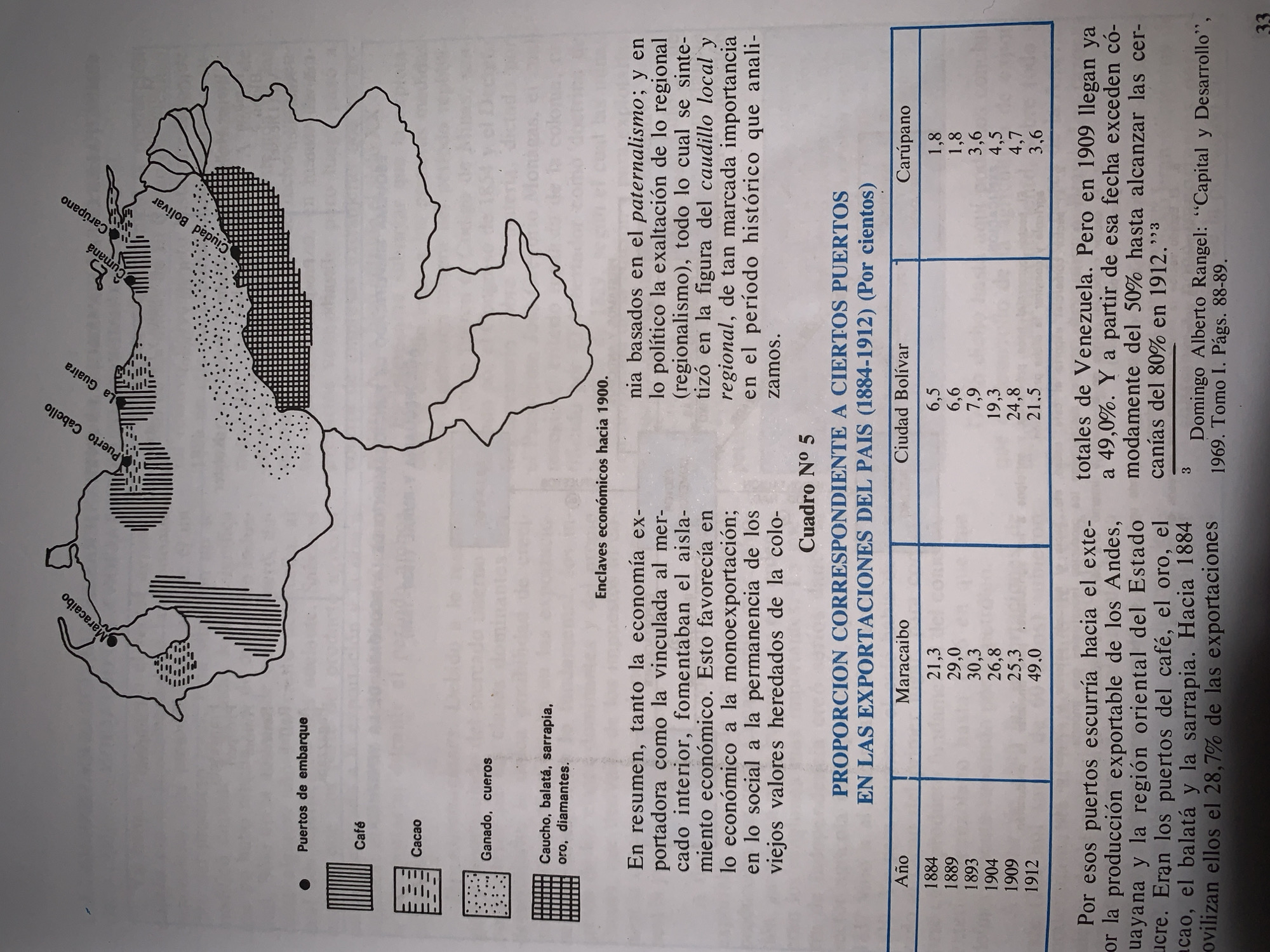
The image displays a page from a book, likely a historical or economic text, titled "Enclaves económicos hacia 1900" (Economic enclaves around 1900). The main subject is a black and white map of Venezuela, illustrating the distribution of key export products and the locations of major shipping ports. The map legend identifies: * **Puertos de embarque (Shipping ports):** Indicated by solid black dots, these include Maracaibo, Puerto Cabello, La Guaira, Cumaná, Carúpano, and Ciudad Bolívar. * **Café (Coffee):** Represented by vertical parallel lines, concentrated in the western region around Maracaibo and extending along parts of the north-central coast. * **Cacao (Cocoa):** Depicted by horizontal parallel lines, primarily found along sections of the northern coast, east of Puerto Cabello and La Guaira, and in a smaller area in the northeast. * **Ganado, cueros (Livestock, hides):** Indicated by stippling (dots), covering a large expanse in the central and eastern plains. * **Caucho, balatá, sarrapia, oro, diamantes (Rubber, balata, tonka bean, gold, diamonds):** Shown with a grid pattern, located in the southern region around Ciudad Bolívar. Accompanying text on the page elaborates on the economic context. The left column discusses the export economy, internal market, economic isolation, and social values. The right column continues this discussion, mentioning paternalism, regionalism, and the figure of the caudillo. Below the map, a table titled "Cuadro N° 5: PROPORCION CORRESPONDIENTE A CIERTOS PUERTOS EN LAS EXPORTACIONES DEL PAIS (1884-1912) (Por cientos)" (Table N° 5: Proportion corresponding to certain ports in the country's exports (1884-1912) (Percentages)) lists export percentages for Maracaibo, Ciudad Bolívar, and Carúpano across various years from 1884 to 1912. For instance, Maracaibo's share ranged from 21.3% in 1884 to 49.0% in 1912. Text below the table further explains that these ports facilitated exports, specifically highlighting Maracaibo's role in the export of products from the Andes, Guayana, and the eastern region of Sucre State, including coffee, gold, cacao, balata, and sarrapia. It notes that Maracaibo's export share reached 49% by 1909 and neared 80% by 1912. A footnote cites Domingo Alberto Rangel's "Capital y Desarrollo," 1969. The page number "33" is visible at the bottom right. The image does not contain any information or mention of the city of Santa Ana, Venezuela.
Symbol
7EFB5
Volume
11,550
Creator
+$0.02
Revenue
+$0.00
TVL
$2.15
Loading AttnAds…