
Sign in
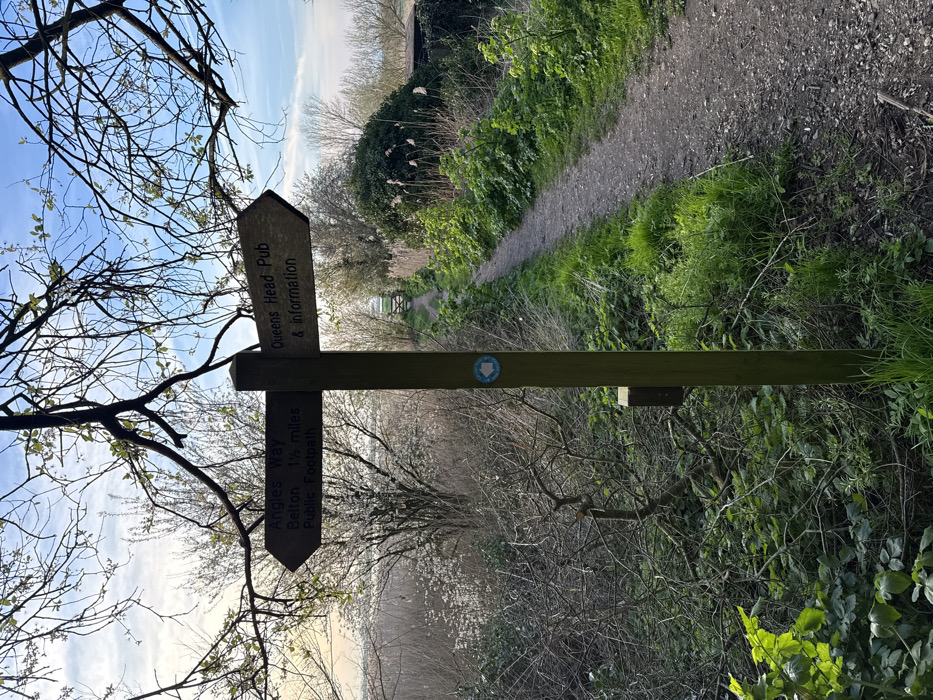
This image depicts a rural public footpath, the Angles Way, located near Belton and Burgh Castle, within the borough of Great Yarmouth, United Kingdom. The scene is captured from a slightly elevated position, looking along a dirt path under a bright blue sky with scattered wispy clouds.

A prominent, weathered wooden signpost stands slightly left of the image center. It features two horizontal, arrow-shaped signs. The left-pointing sign is marked "Angles Way", "Belton 1½ miles", and "Public Footpath". The right-pointing sign reads "Queens Head Pub & information". A circular blue and white waymarker disk, displaying a left-pointing arrow, is attached to the post below the directional signs.

The unpaved footpath, composed of dirt and small stones, begins in the lower right foreground and curves gently to the right as it extends into the distance, leading towards a wooden gate partially visible in the far background. Dense, unmanaged vegetation borders both sides of the path. To the left, a wild area of leafless shrubs and trees, along with a tree bearing white blossoms, descends into a lower section of the landscape. To the right of the path, robust green undergrowth, tall reeds, and bushes line the route. Bare tree branches with nascent leaves frame the top of the image. Natural daylight illuminates the scene, with no individuals or animals present.
Deni🌺

Mar 19, 2026, 5:21 PM

Great Yarmouth, UK

Stake attention in this memory

Peaceful
Tranquil
Serene
Refreshing
Hopeful

This image depicts a rural public footpath, the Angles Way, located near Belton and Burgh Castle, within the borough of Great Yarmouth, United Kingdom. The scene is captured from a slightly elevated position, looking along a dirt path under a bright blue sky with scattered wispy clouds. A prominent, weathered wooden signpost stands slightly left of the image center. It features two horizontal, arrow-shaped signs. The left-pointing sign is marked "Angles Way", "Belton 1½ miles", and "Public Footpath". The right-pointing sign reads "Queens Head Pub & information". A circular blue and white waymarker disk, displaying a left-pointing arrow, is attached to the post below the directional signs. The unpaved footpath, composed of dirt and small stones, begins in the lower right foreground and curves gently to the right as it extends into the distance, leading towards a wooden gate partially visible in the far background. Dense, unmanaged vegetation borders both sides of the path. To the left, a wild area of leafless shrubs and trees, along with a tree bearing white blossoms, descends into a lower section of the landscape. To the right of the path, robust green undergrowth, tall reeds, and bushes line the route. Bare tree branches with nascent leaves frame the top of the image. Natural daylight illuminates the scene, with no individuals or animals present.

Loading AttnAds…

transactions
revenues
stakers
Earliest
Latest
Highest stake

No transactions found

More from this user

More from Great Yarmouth

Deni🌺

Mar 19, 2026, 5:21 PM

Great Yarmouth, UK

Licensed under Creative Commons Attribution 4.0 International License. You are free to share and adapt this content with proper attribution.