Stake attention in this memory
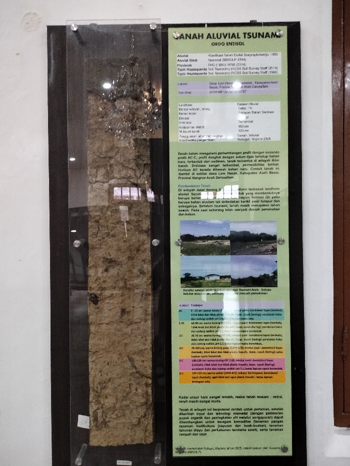
The image displays a soil profile sample encased in glass on the left, next to an informational plaque on the right, both mounted on a white wall. The setting appears to be an indoor exhibition space, possibly a museum or educational institution. Reflections, resembling a chandelier or light fixture, are visible on the glass covering the soil sample. The soil profile itself shows distinct layers of brownish and yellowish soil, indicating different horizons. The informational plaque, titled "TANAH ALUVIAL TSUNAMI" (Tsunami Alluvial Soil) with "ORDO ENTISOL," provides detailed pedological information. It classifies the soil as Alluvial, Aluvial Gleik, and Fluvisols, with specific taxonomic names. The location is identified as Desa Lam Hasan, Kabupaten Aceh Besar, Provinsi Nangroe Aceh Darussalam, with coordinates provided. Details about the landform, elevation, drainage, and effective depth of the soil are also listed. The text explains that the soil has an undeveloped profile (AC-C), is shallow, and is formed from sediments in a wet climate. It specifically references the "Tsunami Aceh," noting that the soil in the region was formerly rice fields and is now residential and agricultural land. Several small photographs below this text show different land uses and possibly conditions before and after the tsunami. A detailed "Horizon Deskripsi" (Horizon Description) section outlines various soil layers from 0-20 cm to 130-150 cm, describing their color, consistency, texture, pH, and presence of roots. The overall nutrient content is described as very low, the soil reaction as acidic-neutral, and the soil as very young. Despite this, the text highlights the soil's potential for agriculture with proper management (organic fertilizers, liming) for various crops, including food, horticulture, perennial crops like oil palm, and medicinal plants. References from "Subagyo, Mopore 2006" and "Subagy, momen 2005" are also visible.
No transactions found