
Sign in
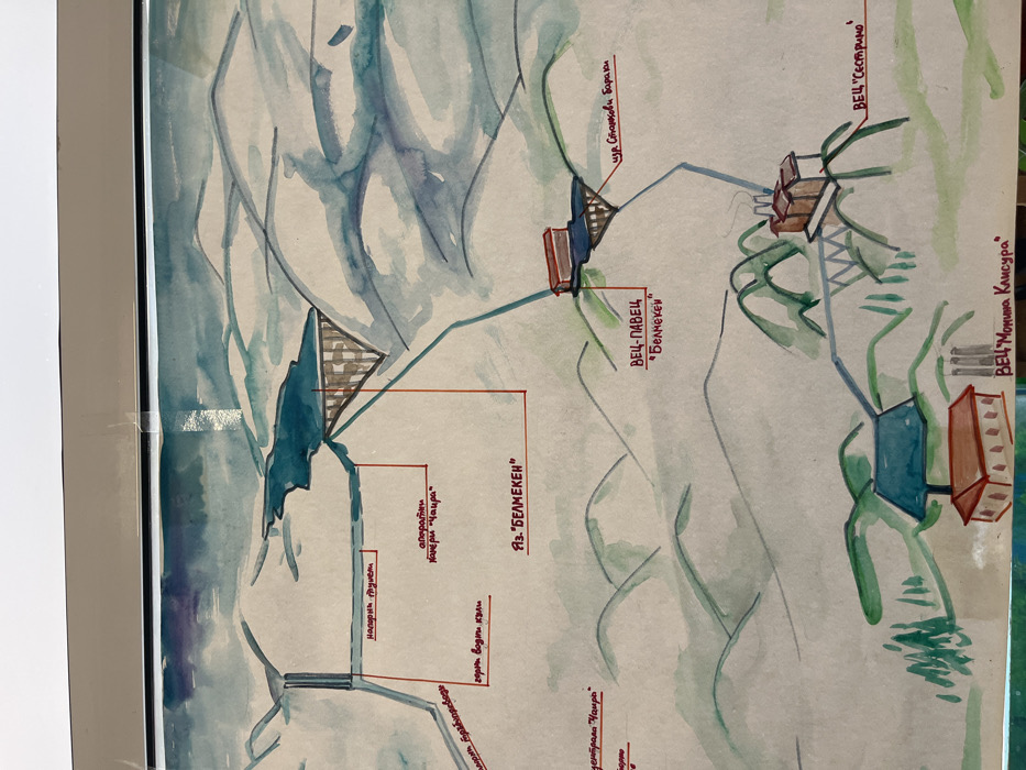
This is a framed, hand-drawn watercolor schematic map depicting a complex hydrological and hydroelectric power system set within mountainous terrain. The artwork is predominantly executed in muted tones of light blue, green, and brown on a light beige paper, secured within a silver-colored frame with clear tape visible at the top edge.

The scene illustrates a cascade system, featuring multiple reservoirs, dams, tunnels, and hydroelectric power plants. Key elements identified by Cyrillic labels include:
*   A prominent reservoir, "ЯЗ. "БЕЛМЕКЕН"" (Belmeken Dam/Reservoir), located in the upper central-right portion, with a brown cross-hatched dam structure.
*   Water channels, represented by blue lines, connecting various components.
*   A power plant, "ВЕЦ-ПАВЕЦ "Белмекен"" (HPP-PAVETS "Belmeken"), situated mid-right on an elevated brown support structure, receiving water from the Belmeken reservoir. Adjacent to it is a label for "ПС Станкови Бараки" (PS Stankovi Baraki - Stankovi Baraki Pumping Station).
*   Further downstream, another power plant, "ВЕЦ "Сестримо"" (HPP "Sestrimo"), is depicted in the lower-right, featuring multiple chimneys and also resting on an elevated support.
*   In the lower-left, a third power plant, "ВЕЦ "Момина Клисура"" (HPP "Momina Klisura"), is shown with a distinctive blue structure and a red-roofed building.
*   In the upper-left, elements such as "напорен дюлем" (pressure tunnel/siphon), "оперативни камери "Чаира"" (operational chambers "Chaira"), and "сборна води клапи" (collective water valves) are labeled, connected by a network of channels leading from an unseen or partially depicted upstream dam. A partially visible label "тунел-деривация "Чаира"" (tunnel-diversion "Chaira") is also present on the far left.

The landscape consists of undulating hills and mountains rendered with sweeping washes of light green and blue-grey, suggesting elevation changes and natural topography. There are no individuals, animals, or vehicles depicted in the schematic. The image is presumed to be located in Panagyurishte, Bulgaria, though the depicted hydroelectric infrastructure of Belmeken-Sestrimo-Chaira-Momina Klisura cascade spans a wider mountainous region within Bulgaria.
Rako

Mar 12, 2026, 10:24 AM

Panagyurishte, Bulgaria

Stake attention in this memory

Serenity
Nostalgia
Curiosity
Engineering
Wonder

This is a framed, hand-drawn watercolor schematic map depicting a complex hydrological and hydroelectric power system set within mountainous terrain. The artwork is predominantly executed in muted tones of light blue, green, and brown on a light beige paper, secured within a silver-colored frame with clear tape visible at the top edge. The scene illustrates a cascade system, featuring multiple reservoirs, dams, tunnels, and hydroelectric power plants. Key elements identified by Cyrillic labels include: * A prominent reservoir, "ЯЗ. "БЕЛМЕКЕН"" (Belmeken Dam/Reservoir), located in the upper central-right portion, with a brown cross-hatched dam structure. * Water channels, represented by blue lines, connecting various components. * A power plant, "ВЕЦ-ПАВЕЦ "Белмекен"" (HPP-PAVETS "Belmeken"), situated mid-right on an elevated brown support structure, receiving water from the Belmeken reservoir. Adjacent to it is a label for "ПС Станкови Бараки" (PS Stankovi Baraki - Stankovi Baraki Pumping Station). * Further downstream, another power plant, "ВЕЦ "Сестримо"" (HPP "Sestrimo"), is depicted in the lower-right, featuring multiple chimneys and also resting on an elevated support. * In the lower-left, a third power plant, "ВЕЦ "Момина Клисура"" (HPP "Momina Klisura"), is shown with a distinctive blue structure and a red-roofed building. * In the upper-left, elements such as "напорен дюлем" (pressure tunnel/siphon), "оперативни камери "Чаира"" (operational chambers "Chaira"), and "сборна води клапи" (collective water valves) are labeled, connected by a network of channels leading from an unseen or partially depicted upstream dam. A partially visible label "тунел-деривация "Чаира"" (tunnel-diversion "Chaira") is also present on the far left. The landscape consists of undulating hills and mountains rendered with sweeping washes of light green and blue-grey, suggesting elevation changes and natural topography. There are no individuals, animals, or vehicles depicted in the schematic. The image is presumed to be located in Panagyurishte, Bulgaria, though the depicted hydroelectric infrastructure of Belmeken-Sestrimo-Chaira-Momina Klisura cascade spans a wider mountainous region within Bulgaria.

Loading AttnAds…

transactions
revenues
stakers
Earliest
Latest
Highest stake

No transactions found

More from this user

More from Panagyurishte

Rako

Mar 12, 2026, 10:24 AM

Panagyurishte, Bulgaria

Licensed under Creative Commons Attribution 4.0 International License. You are free to share and adapt this content with proper attribution.