
Sign in
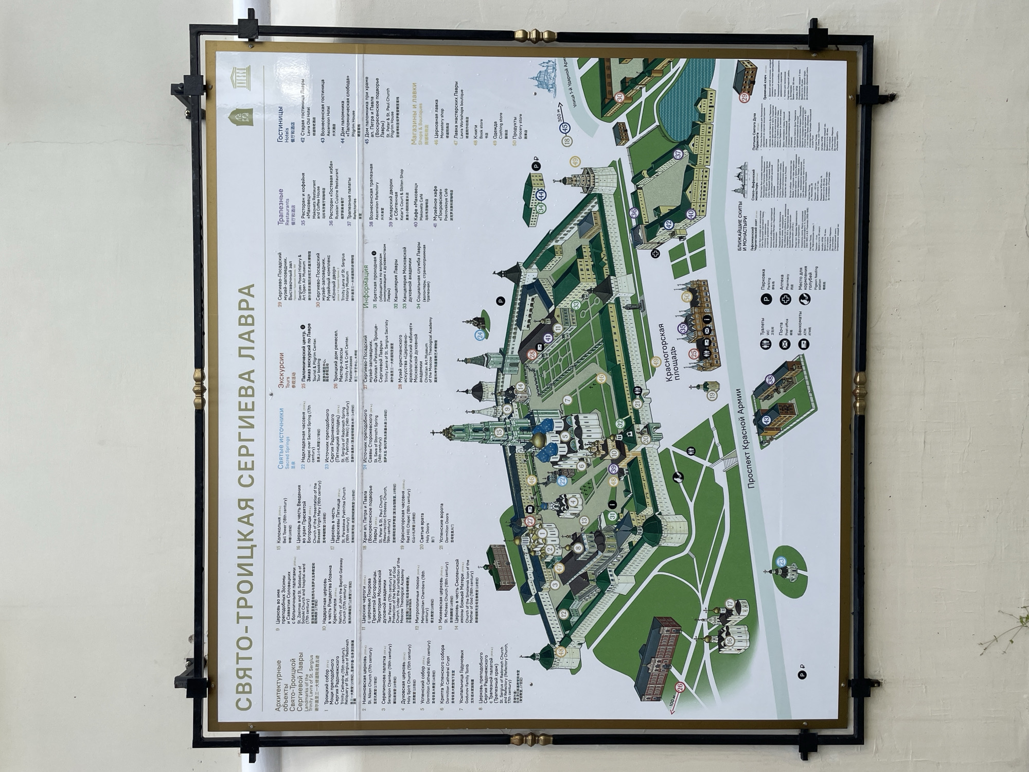
This image is a detailed map of the Trinity Lavra of St. Sergius, a major Russian Orthodox monastery in the city of Sergiyev Posad, Moscow Oblast, Russia. The map is mounted on a wall, framed by black metal borders and decorative brass elements. It is a colorful, illustrative depiction of the monastery complex, featuring individual buildings, courtyards, and surrounding areas.

The map is divided into several sections with labels in Russian and English, including "Architectural objects," "Excursions," "Restaurants," "Hotels," "Shops & Boutiques," and "Nearby Skits and Monasteries." It also includes a legend with icons for "Toilets," "Parking," "Post office," "Pharmacy," and "Place for feeding pigeons."

The central part of the map shows a bird's-eye view of the monastery grounds, with numerous numbered structures and pathways. The Trinity Lavra itself is prominently displayed, with its iconic bell tower and numerous churches. The surrounding environment includes green spaces, water features, and adjacent urban areas, including "Krasnogorskaya Square" and "Prospekt Krasnoy Armii" (Red Army Avenue).

The map appears to be an informational display for visitors, providing orientation and highlighting various points of interest within the monastery and its vicinity. The overall presentation is clean and organized, designed to be informative and visually appealing. The surrounding wall is textured and off-white, suggesting it is an outdoor or semi-outdoor location, possibly at the entrance to the complex or a visitor center. There are no people visible in the image.
Елен.А

Jul 9, 2026, 2:30 PM

Sergiyev Posad, Russia

Stake attention in this memory

informative
historical
architectural
detailed
navigational

This image is a detailed map of the Trinity Lavra of St. Sergius, a major Russian Orthodox monastery in the city of Sergiyev Posad, Moscow Oblast, Russia. The map is mounted on a wall, framed by black metal borders and decorative brass elements. It is a colorful, illustrative depiction of the monastery complex, featuring individual buildings, courtyards, and surrounding areas. The map is divided into several sections with labels in Russian and English, including "Architectural objects," "Excursions," "Restaurants," "Hotels," "Shops & Boutiques," and "Nearby Skits and Monasteries." It also includes a legend with icons for "Toilets," "Parking," "Post office," "Pharmacy," and "Place for feeding pigeons." The central part of the map shows a bird's-eye view of the monastery grounds, with numerous numbered structures and pathways. The Trinity Lavra itself is prominently displayed, with its iconic bell tower and numerous churches. The surrounding environment includes green spaces, water features, and adjacent urban areas, including "Krasnogorskaya Square" and "Prospekt Krasnoy Armii" (Red Army Avenue). The map appears to be an informational display for visitors, providing orientation and highlighting various points of interest within the monastery and its vicinity. The overall presentation is clean and organized, designed to be informative and visually appealing. The surrounding wall is textured and off-white, suggesting it is an outdoor or semi-outdoor location, possibly at the entrance to the complex or a visitor center. There are no people visible in the image.

Loading AttnAds…

transactions
revenues
stakers
Earliest
Latest
Highest stake

No transactions found

More from this user

More from Sergiyev Posad

Елен.А

Jul 9, 2026, 2:30 PM

Sergiyev Posad, Russia

Licensed under Creative Commons Attribution 4.0 International License. You are free to share and adapt this content with proper attribution.