
Sign in
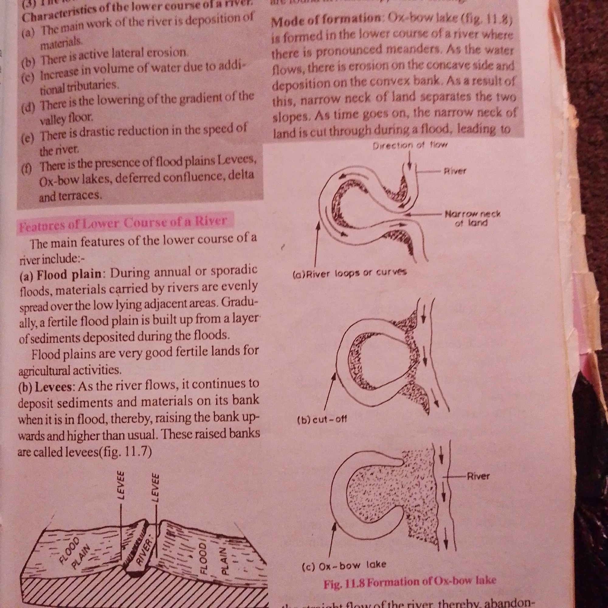
The image is a scan of a textbook page discussing river features, specifically the lower course of a river and the formation of ox-bow lakes. It contains text and diagrams.

The text on the left lists characteristics of the lower course of a river, including deposition, lateral erosion, increase in water volume from tributaries, lowering of the gradient, drastic reduction in speed, and the presence of floodplains, levees, ox-bow lakes, deferred confluence, deltas, and terraces. It then details the features of the lower course, describing floodplains as areas of deposition during floods and levees as raised banks formed by sediment deposition.

The text on the right describes the mode of formation of ox-bow lakes, explaining how meanders form, erosion occurs on the concave bank, and deposition on the convex bank. It illustrates how a narrow neck of land separating two meanders can be cut through during a flood, leading to the formation of an ox-bow lake.

The diagrams on the right illustrate this process:
*   **(a) River loops or curves:** Shows a meandering river.
*   **(b) cut-off:** Depicts a meander being cut off.
*   **(c) Ox-bow lake:** Shows the final formation of an ox-bow lake.

Below the text and diagrams on the right, a caption reads "Fig. 11.8 Formation of Ox-bow lake".

The diagram at the bottom of the left column shows a cross-section of a river, illustrating a river channel with levees on either side, bordered by floodplains.

There is no information in the image that provides any context about the city of Jalingo, Nigeria.
FM-66btC3

Jun 30, 2026, 4:05 PM

Jalingo, Nigeria

Moment

Stake attention in this memory

studious
analytical
focused
informative
academic

The image is a scan of a textbook page discussing river features, specifically the lower course of a river and the formation of ox-bow lakes. It contains text and diagrams. The text on the left lists characteristics of the lower course of a river, including deposition, lateral erosion, increase in water volume from tributaries, lowering of the gradient, drastic reduction in speed, and the presence of floodplains, levees, ox-bow lakes, deferred confluence, deltas, and terraces. It then details the features of the lower course, describing floodplains as areas of deposition during floods and levees as raised banks formed by sediment deposition. The text on the right describes the mode of formation of ox-bow lakes, explaining how meanders form, erosion occurs on the concave bank, and deposition on the convex bank. It illustrates how a narrow neck of land separating two meanders can be cut through during a flood, leading to the formation of an ox-bow lake. The diagrams on the right illustrate this process: * **(a) River loops or curves:** Shows a meandering river. * **(b) cut-off:** Depicts a meander being cut off. * **(c) Ox-bow lake:** Shows the final formation of an ox-bow lake. Below the text and diagrams on the right, a caption reads "Fig. 11.8 Formation of Ox-bow lake". The diagram at the bottom of the left column shows a cross-section of a river, illustrating a river channel with levees on either side, bordered by floodplains. There is no information in the image that provides any context about the city of Jalingo, Nigeria.

Symbol

8D3CA

Volume

2,990

Creator

+$0.00

Revenue

+$0.01

TVL

$0.23

1D
1W
1M
All

Loading AttnAds…

transactions
revenues
stakers
Earliest
Latest
Highest stake

1

FM-mmBz23

Staked 1mo ago

$0.22 USD

+$0.00 USD

+2%

2

Rev Bot 🤖💰

Injected revenue 1mo ago

Revenue bonus for the last stake.

+$0.01 USD

More from this user

More from Jalingo

FM-66btC3

Jun 30, 2026, 4:05 PM

Jalingo, Nigeria

Licensed under Creative Commons Attribution 4.0 International License. You are free to share and adapt this content with proper attribution.