Sign in
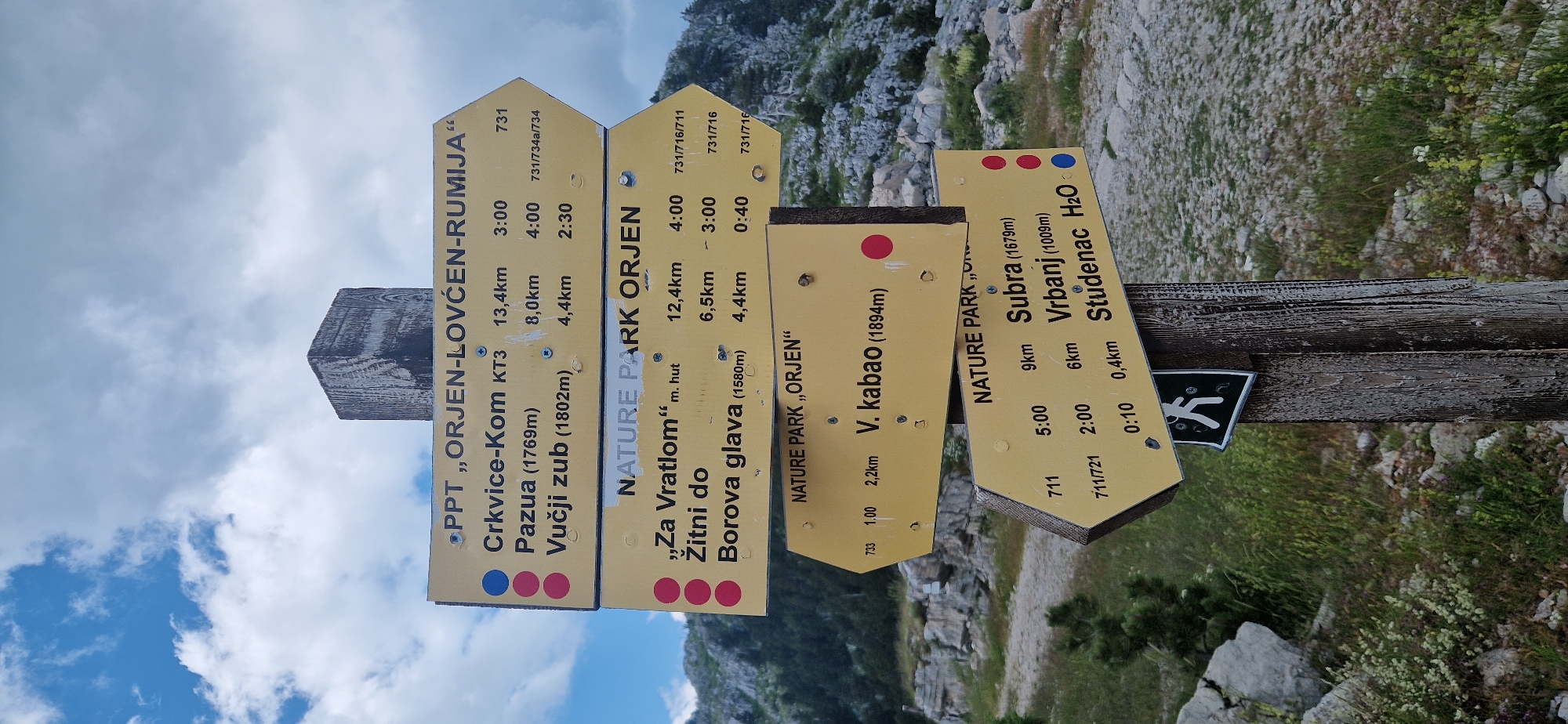
The image shows a wooden signpost with multiple directional signs in the mountainous terrain of Dragalj, Montenegro. The signs are yellow with black lettering and provide information about hiking routes, distances, and estimated times.

The top sign reads "PPT „ORJEN-LOVĆEN-RUMIJA“" and lists three destinations: "Crkvice-Kom KT3" (13.4 km, 3:00), "Pazua (1769m)" (8.0 km, 4:00), and "Vučji zub (1802m)" (4.4 km, 2:30). Each destination is marked with colored dots.

The second sign from the top reads "NATURE PARK „ORJEN“" and lists three destinations: "„Za Vratlom“ m. hut" (12.4 km, 4:00), "Žitni do" (6.5 km, 3:00), and "Borova glava (1580m)" (4.4 km, 0:40). These destinations also have colored dots.

The third sign from the top is a directional arrow pointing to the left and reads "NATURE PARK „ORJEN“" with "V. kabao (1894m)" and some numbers. It also has a red dot.

The bottom sign is another directional arrow pointing to the left and reads "NATURE PARK „ORJEN“" listing "Subra (1679m)" (9km, 5:00), "Vrbanj (1009m)" (6km, 2:00), and "Studenac H₂O" (0.4km, 0:10). This sign also has colored dots. Below this sign, there is a smaller black and white sign depicting a hiker.

The background consists of rocky, sparsely vegetated slopes under a cloudy sky. The overall scene depicts a trail marker in a natural, outdoor environment.
B
Bandik

Jun 21, 2026, 12:16 PM

Dragalj, Montenegro

Stake attention in this memory

adventure
exploration
serenity
hope
excitement

The image shows a wooden signpost with multiple directional signs in the mountainous terrain of Dragalj, Montenegro. The signs are yellow with black lettering and provide information about hiking routes, distances, and estimated times. The top sign reads "PPT „ORJEN-LOVĆEN-RUMIJA“" and lists three destinations: "Crkvice-Kom KT3" (13.4 km, 3:00), "Pazua (1769m)" (8.0 km, 4:00), and "Vučji zub (1802m)" (4.4 km, 2:30). Each destination is marked with colored dots. The second sign from the top reads "NATURE PARK „ORJEN“" and lists three destinations: "„Za Vratlom“ m. hut" (12.4 km, 4:00), "Žitni do" (6.5 km, 3:00), and "Borova glava (1580m)" (4.4 km, 0:40). These destinations also have colored dots. The third sign from the top is a directional arrow pointing to the left and reads "NATURE PARK „ORJEN“" with "V. kabao (1894m)" and some numbers. It also has a red dot. The bottom sign is another directional arrow pointing to the left and reads "NATURE PARK „ORJEN“" listing "Subra (1679m)" (9km, 5:00), "Vrbanj (1009m)" (6km, 2:00), and "Studenac H₂O" (0.4km, 0:10). This sign also has colored dots. Below this sign, there is a smaller black and white sign depicting a hiker. The background consists of rocky, sparsely vegetated slopes under a cloudy sky. The overall scene depicts a trail marker in a natural, outdoor environment.

Loading AttnAds…

transactions
revenues
stakers
Earliest
Latest
Highest stake

No transactions found

More from this user

More from Dragalj

BBandik

Jun 21, 2026, 12:16 PM

Dragalj, Montenegro

Licensed under Creative Commons Attribution 4.0 International License. You are free to share and adapt this content with proper attribution.