
Sign in
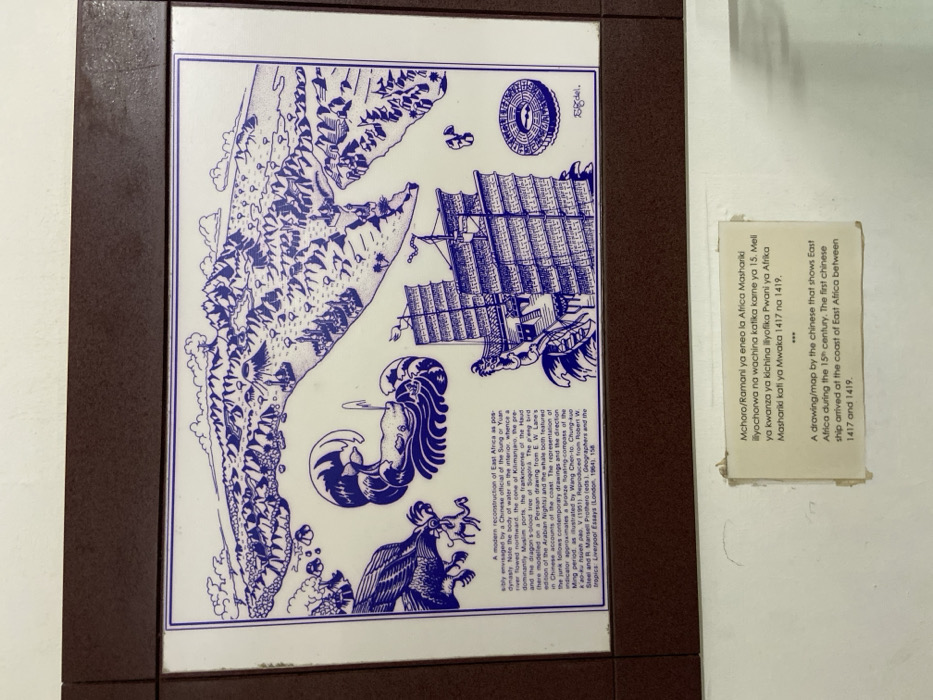
The image is a framed map of the coast of East Africa, located at the National Museum of Tanzania in Dar es Salaam, Tanzania. The map is drawn in blue and white, with the coastline depicted in detail. The map is accompanied by an inscription in Swahili and English. The Swahili inscription translates to "A drawing/map by the Chinese that shows East Africa during the 15th century. The first Chinese ship arrived at the coast of East Africa between 1417 and 1419." The English inscription is a similar explanation of the map. The map depicts a large Chinese ship, which symbolizes the arrival of Chinese ships to the coast of East Africa during the 15th century. The map also contains other symbols such as a dragon, a phoenix, and a compass. The inscription below the map describes the map as a modern reconstruction of East Africa as possibly envisaged by a Chinese official of the Sung or Yuan dynasty. The inscription further describes the use of the dragon, phoenix, and the compass in the map, referencing them as features that represent the interior of the land. The map is a historical artifact that provides valuable insights into the interactions between China and East Africa during the 15th century. The map is framed in a brown wooden frame. The National Museum of Tanzania is a cultural institution that collects, preserves, and displays artifacts that showcase the history and culture of Tanzania. The museum is a popular tourist attraction, providing visitors with an opportunity to learn about the rich heritage of the country.
FM-hlmC83

Apr 12, 2025, 10:17 AM

Dar es Salaam, Tanzania

Stake attention in this memory

historical
ancient
exploratory
cartographic
geographic

The image is a framed map of the coast of East Africa, located at the National Museum of Tanzania in Dar es Salaam, Tanzania. The map is drawn in blue and white, with the coastline depicted in detail. The map is accompanied by an inscription in Swahili and English. The Swahili inscription translates to "A drawing/map by the Chinese that shows East Africa during the 15th century. The first Chinese ship arrived at the coast of East Africa between 1417 and 1419." The English inscription is a similar explanation of the map. The map depicts a large Chinese ship, which symbolizes the arrival of Chinese ships to the coast of East Africa during the 15th century. The map also contains other symbols such as a dragon, a phoenix, and a compass. The inscription below the map describes the map as a modern reconstruction of East Africa as possibly envisaged by a Chinese official of the Sung or Yuan dynasty. The inscription further describes the use of the dragon, phoenix, and the compass in the map, referencing them as features that represent the interior of the land. The map is a historical artifact that provides valuable insights into the interactions between China and East Africa during the 15th century. The map is framed in a brown wooden frame. The National Museum of Tanzania is a cultural institution that collects, preserves, and displays artifacts that showcase the history and culture of Tanzania. The museum is a popular tourist attraction, providing visitors with an opportunity to learn about the rich heritage of the country.

Loading AttnAds…

transactions
revenues
stakers
Earliest
Latest
Highest stake

No transactions found

More from this user

More from Dar es Salaam

FM-hlmC83

Apr 12, 2025, 10:17 AM

Dar es Salaam, Tanzania

Licensed under Creative Commons Attribution 4.0 International License. You are free to share and adapt this content with proper attribution.