Stake attention in this memory
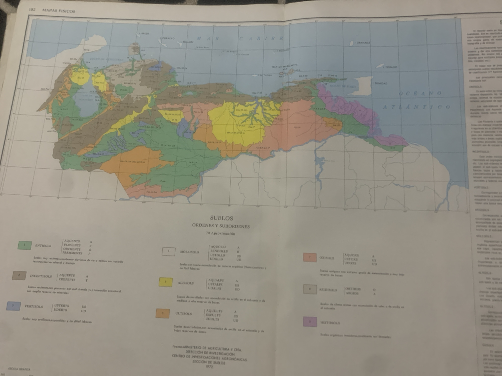
This media file is a photograph of a printed map titled "MAPAS FISICOS" (Physical Maps). The map displays geographical information, including coastlines, bodies of water, islands, and political boundaries. The main focus of the map is the northern region of South America, specifically Venezuela and surrounding areas, including the Caribbean Sea and parts of the Atlantic Ocean. The map is overlaid with different colored regions, each representing various soil types, as indicated by the legend at the bottom. The legend categorizes soils into orders such as Entisols, Inceptisols, Vertisols, Mollisols, Alfisols, Ultisols, Oxisols, Aridisols, and Histosols, along with their suborders and corresponding letter codes. There are also numerical labels scattered across the map, likely indicating specific soil classifications or geographical features. Text visible on the map includes place names like "CURAZAO," "BONAIRE," "MAR CARIBE," "ISLA DE MARGARITA," "GRANADA," "TOBAGO," "TRINIDAD," and "OCEANO ATLANTICO." The legend also contains descriptive text about each soil type in Spanish, such as "Suelos muy recientes," "Suelos recientes con procesos por mal drenaje," and "Suelos muy arcillosos expansibles." At the bottom of the legend, there is information about the source of the data: "Fuente: MINISTERIO DE AGRICULTURA Y CRÍA. DIRECCIÓN DE INVESTIGACIÓN. CENTRO DE INVESTIGACIONES AGRONÓMICAS. SECCIÓN DE SUELOS. 1972." The image appears to be taken in a well-lit indoor environment, possibly an office or study, with the map spread out on a flat surface. There are no people or active events depicted in the photograph itself, which focuses solely on the printed map. The overall impression is one of an academic or informational document.
Symbol
93C19
Volume
11,550
Creator
+$0.13
Revenue
+$0.17
TVL
$11.55
2
Rev Bot 🤖💰
Injected revenue 6d ago
“Revenue bonus for the last stake.”
+$0.18 USD