Sign in
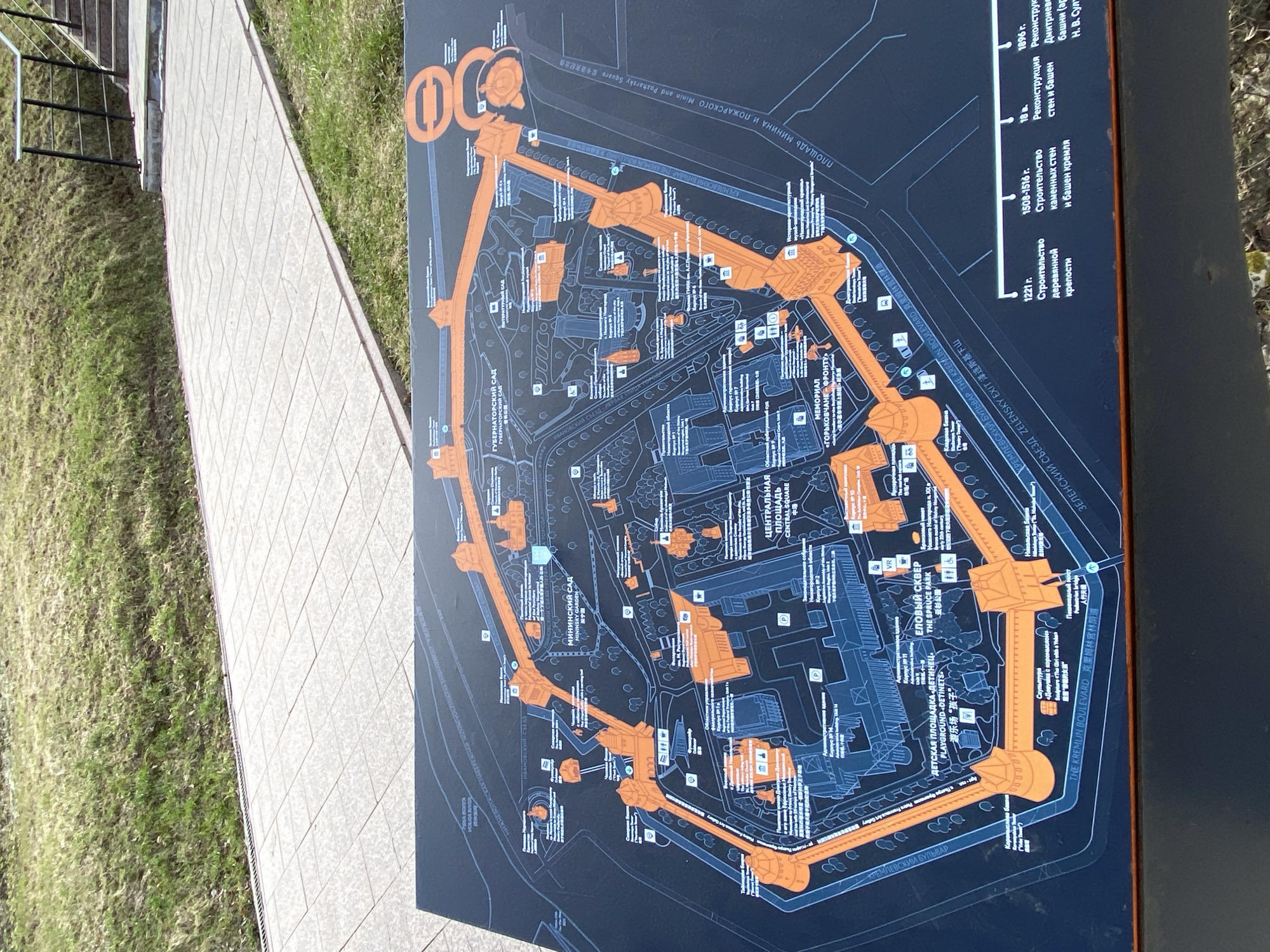
The image displays a large, dark-colored outdoor information board, oriented vertically and featuring a detailed map of a historical complex, identified as the Nizhny Novgorod Kremlin through visible text and location context. The map is designed with orange outlines highlighting the Kremlin walls, towers, and main structures against a dark background.

The board provides an aerial view of the Kremlin grounds, illustrating various points of interest such as "ПЛОЩАДЬ МИНИНА И ПОЖАРСКОГО" (Minin and Pozharsky Square), "КРЕМЛЕВСКИЙ БУЛЬВАР" (The Kremlin Boulevard), "МИНИНСКИЙ САД" (Mininsky Garden), "ГУБЕРНАТОРСКИЙ САД" (Governor's Garden), "ЦЕНТРАЛЬНАЯ ПЛОЩАДЬ" (Central Square), "ЕЛОВЫЙ СКВЕР" (The Spruce Park), and a "ДЕТСКАЯ ПЛОЩАДКА «ДЕТИНЕЦ»" (Detinets Playground). Several buildings, pathways, and icons indicating facilities like parking, restrooms, and VR experiences are also visible.

Historical information is presented on the right side of the map, detailing key construction phases: "1221 г. Строительство деревянной крепости" (1221 - Construction of the wooden fortress) and "1508-1516 г. Строительство каменных стен и башен кремля" (1508-1516 - Construction of stone walls and Kremlin towers), along with an 18th-century reconstruction.

All prominent labels on the map are presented in three languages: Russian, English, and Chinese. The map is positioned next to a paved pathway, with green grass visible on either side. The lighting suggests a bright, sunny day. The image is taken at an angle, with the map itself appearing rotated, making some text sideways. No people are visible in the frame.
A13

Apr 17, 2026, 8:55 AM

Nizhny Novgorod, Russia

Stake attention in this memory

Informative
Historical
Educational
Curious
Analytical

The image displays a large, dark-colored outdoor information board, oriented vertically and featuring a detailed map of a historical complex, identified as the Nizhny Novgorod Kremlin through visible text and location context. The map is designed with orange outlines highlighting the Kremlin walls, towers, and main structures against a dark background. The board provides an aerial view of the Kremlin grounds, illustrating various points of interest such as "ПЛОЩАДЬ МИНИНА И ПОЖАРСКОГО" (Minin and Pozharsky Square), "КРЕМЛЕВСКИЙ БУЛЬВАР" (The Kremlin Boulevard), "МИНИНСКИЙ САД" (Mininsky Garden), "ГУБЕРНАТОРСКИЙ САД" (Governor's Garden), "ЦЕНТРАЛЬНАЯ ПЛОЩАДЬ" (Central Square), "ЕЛОВЫЙ СКВЕР" (The Spruce Park), and a "ДЕТСКАЯ ПЛОЩАДКА «ДЕТИНЕЦ»" (Detinets Playground). Several buildings, pathways, and icons indicating facilities like parking, restrooms, and VR experiences are also visible. Historical information is presented on the right side of the map, detailing key construction phases: "1221 г. Строительство деревянной крепости" (1221 - Construction of the wooden fortress) and "1508-1516 г. Строительство каменных стен и башен кремля" (1508-1516 - Construction of stone walls and Kremlin towers), along with an 18th-century reconstruction. All prominent labels on the map are presented in three languages: Russian, English, and Chinese. The map is positioned next to a paved pathway, with green grass visible on either side. The lighting suggests a bright, sunny day. The image is taken at an angle, with the map itself appearing rotated, making some text sideways. No people are visible in the frame.

Loading AttnAds…

transactions
revenues
stakers
Earliest
Latest
Highest stake

No transactions found

More from this user

More from Nizhny Novgorod

A13

Apr 17, 2026, 8:55 AM

Nizhny Novgorod, Russia

Licensed under Creative Commons Attribution 4.0 International License. You are free to share and adapt this content with proper attribution.