
Sign in
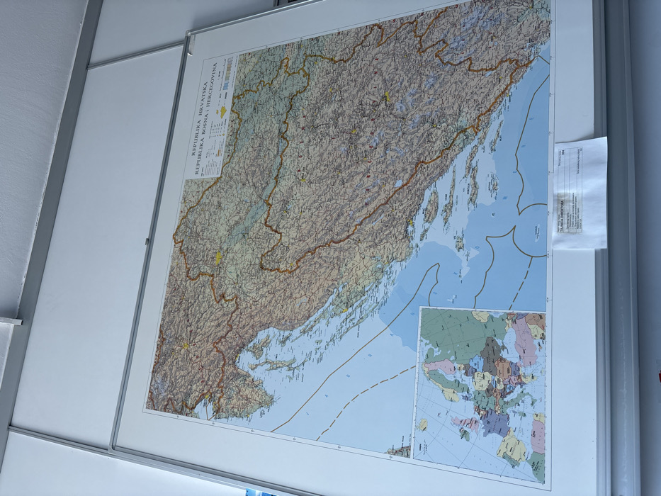
The image displays a large, detailed map mounted on a light-colored wall, likely indoors. The map is positioned vertically on the wall, and the photograph is taken at an angle, causing the map to appear tilted to the right. A silver-colored frame or mounting system holds the map in place against the white wall. The ceiling, also white, is visible in the upper left corner of the frame.

The main map depicts the Western Balkan region, specifically highlighting the countries of Croatia and Bosnia and Herzegovina. The title in the upper left corner of the map clearly reads "REPUBLIKA HRVATSKA" (Republic of Croatia) and "REPUBLIKA BOSNA I HERCEGOVINA" (Republic of Bosnia and Herzegovina). The map is rich in geographical detail, showing a combination of physical and political features. The land areas are colored with varying shades of green, brown, and grey, indicating elevation changes, with mountainous regions being particularly prominent in Bosnia and Herzegovina and inland Croatia. Numerous cities, towns, and road networks are marked across both countries.

The Adriatic Sea dominates the western part of the map, featuring a vast coastline belonging to Croatia, dotted with countless islands and islets. The sea itself is colored in light blue, and various maritime boundaries or zones are indicated by thin lines.

In the lower right corner of the main map, there is an inset map showing the broader European continent. This smaller map uses different colors to distinguish various countries across Europe, providing a contextual view of the main mapped region within Europe.

To the right of the main map, a small, rectangular piece of paper is taped to the white frame. Although partially obscured and angled, some text is legible. The most prominent readable text is "TEHNIKA OPREME," which translates to "Technical Equipment." Below this, there are fields common on inventory or equipment forms, such as "MJESTO I DATUM" (Place and Date), "UREĐAJ" (Device/Equipment), "VRSTA" (Type), "SER. BR." (Serial No.), and "INV. BR." (Inventory No.), with lines for information to be filled in.

The overall lighting suggests an indoor setting, possibly during the daytime, as there are no obvious artificial light sources or shadows indicating night. The scene is static, depicting an informational display on a wall.
Vazda

Feb 23, 2026, 1:58 PM

City of Zagreb, Croatia

Stake attention in this memory

map
Croatia
Bosnia and Herzegovina
Europe
geography

The image displays a large, detailed map mounted on a light-colored wall, likely indoors. The map is positioned vertically on the wall, and the photograph is taken at an angle, causing the map to appear tilted to the right. A silver-colored frame or mounting system holds the map in place against the white wall. The ceiling, also white, is visible in the upper left corner of the frame. The main map depicts the Western Balkan region, specifically highlighting the countries of Croatia and Bosnia and Herzegovina. The title in the upper left corner of the map clearly reads "REPUBLIKA HRVATSKA" (Republic of Croatia) and "REPUBLIKA BOSNA I HERCEGOVINA" (Republic of Bosnia and Herzegovina). The map is rich in geographical detail, showing a combination of physical and political features. The land areas are colored with varying shades of green, brown, and grey, indicating elevation changes, with mountainous regions being particularly prominent in Bosnia and Herzegovina and inland Croatia. Numerous cities, towns, and road networks are marked across both countries. The Adriatic Sea dominates the western part of the map, featuring a vast coastline belonging to Croatia, dotted with countless islands and islets. The sea itself is colored in light blue, and various maritime boundaries or zones are indicated by thin lines. In the lower right corner of the main map, there is an inset map showing the broader European continent. This smaller map uses different colors to distinguish various countries across Europe, providing a contextual view of the main mapped region within Europe. To the right of the main map, a small, rectangular piece of paper is taped to the white frame. Although partially obscured and angled, some text is legible. The most prominent readable text is "TEHNIKA OPREME," which translates to "Technical Equipment." Below this, there are fields common on inventory or equipment forms, such as "MJESTO I DATUM" (Place and Date), "UREĐAJ" (Device/Equipment), "VRSTA" (Type), "SER. BR." (Serial No.), and "INV. BR." (Inventory No.), with lines for information to be filled in. The overall lighting suggests an indoor setting, possibly during the daytime, as there are no obvious artificial light sources or shadows indicating night. The scene is static, depicting an informational display on a wall.

Loading AttnAds…

transactions
revenues
stakers
Earliest
Latest
Highest stake

No transactions found

More from this user

More from City of Zagreb

Vazda

Feb 23, 2026, 1:58 PM

City of Zagreb, Croatia

Licensed under Creative Commons Attribution 4.0 International License. You are free to share and adapt this content with proper attribution.