Stake attention in this memory
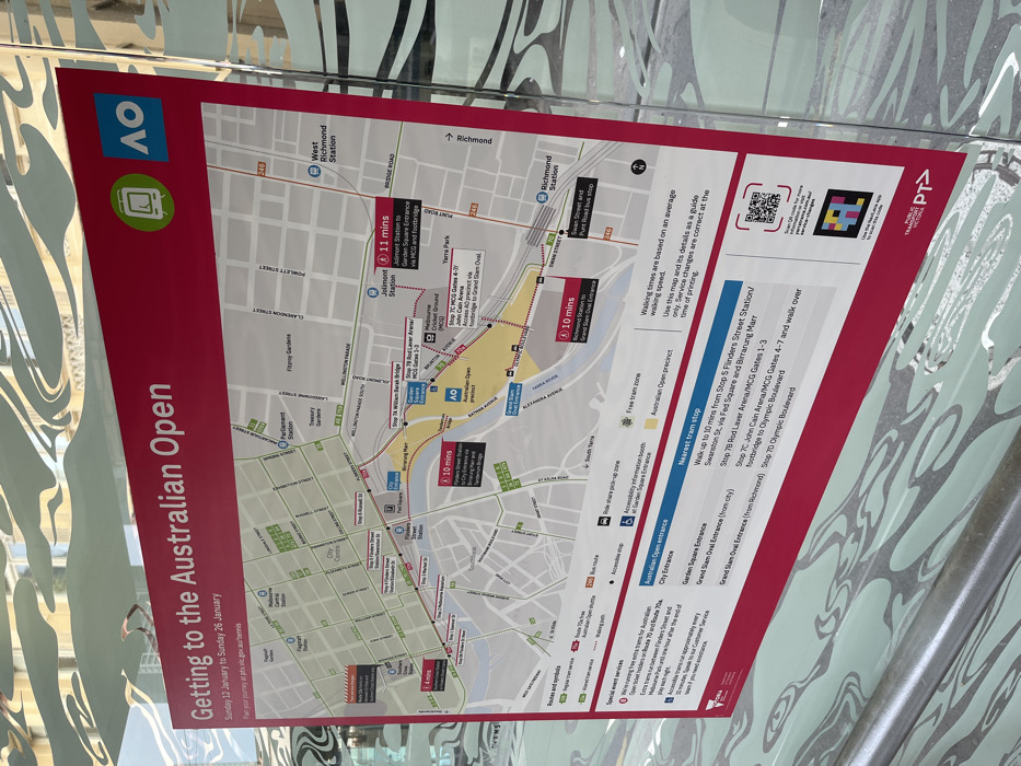
A large informational poster, angled slightly, is displayed indoors against a modern, patterned glass wall. The poster's main subject is "Getting to the Australian Open," with dates listed as "Sunday 12 January to Sunday 26 January." The poster features a detailed map of the Melbourne city center and surrounding areas, highlighting key landmarks and transport routes relevant to the Australian Open precinct, which is marked in yellow. Key locations visible on the map include Flinders Street Station, Richmond Station, Jolimont Station, Parliament Station, Melbourne Central, the Yarra River, MCG (Melbourne Cricket Ground), John Cain Arena, and Rod Laver Arena. Numerous walking times and public transport options are indicated. For instance, walking from Jolimont Station to the Garden Square Entrance via the MCG is estimated at "11 mins," while Richmond Station to the Grand Slam Oval Entrance is "10 mins." The map also shows various tram stops, including Stop 5 Flinders Street Station/Swanston St, Stop 7B Rod Laver Arena/MCG Gates 1-3, and Stop 7C John Cain Arena/MCG Gates 4-7. Textual information on the poster clarifies that walking times are based on an average speed and advises using the map as a guide, noting that service changes are correct at the time of printing. It also provides a website for journey planning: ptv.vic.gov.au/tennis. Logos for the "AO" (Australian Open) and "PT" (Public Transport Victoria) are prominently displayed. Two QR codes are visible, offering digital access to more information. The background's abstract, wavy pattern suggests a contemporary architectural setting, likely a public space or transport hub.
No transactions found


