Stake attention in this memory
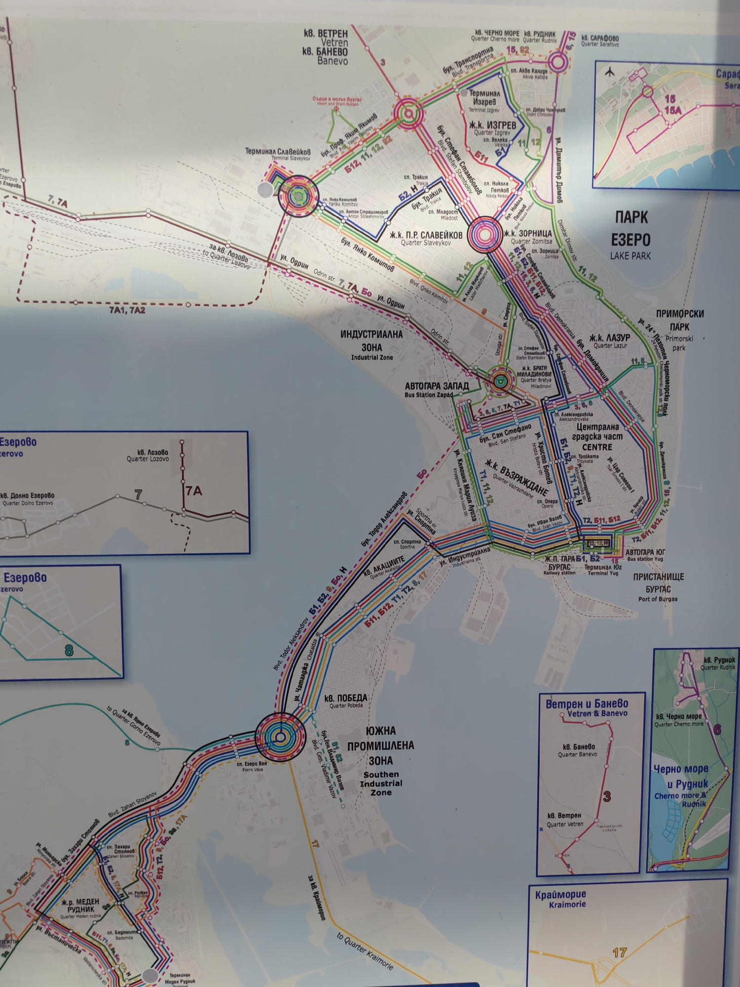
The image is a map of public transportation routes in the city of Burgas, Bulgaria. It displays various bus and tram lines, indicated by different colored lines and numbers, connecting different districts, neighborhoods (kvartal), and points of interest. Key locations marked on the map include: * **Kvartal Vetren & Banevo:** Two distinct routes (one with number 3, the other with a red line) are shown connecting these areas to the city center. * **Kvartal Chérno More & Rudnik:** A route labeled with the number 6 is depicted in this area. * **Kvartal Safarovo:** This area is indicated with routes 15 and 15A. * **Terminal Slaveykov:** A major transportation hub with several routes converging. * **Kvartal Izgrev:** Served by routes 11 and 12. * **Kvartal Zornitsa:** Served by routes 11, 12, and a central route. * **Bus Station Zapad (West):** A connection point for routes 5, 6, 7, 7A, and 11. * **Centar (Center):** The heart of the city with many routes passing through, including 5, 511, T2, T2H, 11, 12, 15, 15A, and 8. * **Kvartal Lazur:** Served by routes 11 and 12. * **Primorski Park:** A recreational area. * **Bus Station Yug (South) - Terminal Yug:** A southern terminal with routes 51, 52, T2, 12, and H. * **Pristanishte Burgas (Port of Burgas):** Located on the coast. * **Kvartal Pobeda:** Served by routes 5, 511, 52, T2, and H. * **Yuzhna Promishlena Zona (Southern Industrial Zone):** An industrial area with routes 1, 7, and T7. * **Kvartal Ezero:** A lakeside area with a route labeled 7 and 7A. * **Kvartal Dolno Ezerovo:** Connected by route 7. * **Kvartal Meden Rudnik:** A large residential area with numerous routes, including 5, 511, 52, T2, 4, 17A, and N. * **Terminal Meden Rudnik:** A terminal for routes in this quarter. * **Kvartal Krakra:** A small area indicated with route 17. * **Kvartal Kraimorie:** A coastal neighborhood with route 17. The map uses a color-coded system for the different routes and includes street names and district names in both Bulgarian and English. It also shows the proximity of the city to the Black Sea coast, with a detailed inset map of the city center and its immediate surroundings, including the port and the beach area. There are no people or actions depicted, as it is a static diagram.
No transactions found