Sign in
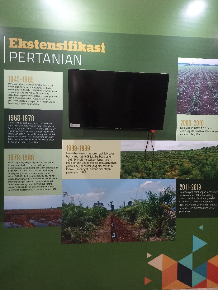
The image is a wall display inside a building, located at coordinates -6.604, 106.797, which places it in the city of Bogor, Indonesia. The display features a wall with green background, with a title "Ekstensifikasi Pertanian" (meaning "Extension of Agriculture"). The wall is divided into five sections, each with a different time period and description of agricultural activities. 

The top section describes "1945-1965", showcasing the expansion of agricultural land area and its impact. The second section "1968-1978" details the development of an integrated system with varying functions. The third section "1978-1988" discusses the transition from conventional to more sustainable methods of agriculture, particularly related to the use of fertilizers. The fourth section "1989-1999" talks about the increasing land area dedicated to agriculture, particularly palm oil, and the implementation of a national program called "Nusa." The fifth section "2000-2010" describes the introduction of two-year rotation systems for palm oil cultivation. The final section "2011-2019" mentions the development of a modern agriculture system with advanced technology and efforts to improve the efficiency of the agricultural sector. 

Each section features a photograph depicting the agricultural practices of the corresponding time period. The photographs show diverse landscapes, including a field of corn, a lush jungle, a field of palm trees, and a landscape dominated by water and vegetation. The photographs are positioned within the borders of the information panels, giving visual context to the written text. The display aims to educate viewers about the evolution of agricultural practices in Indonesia, highlighting significant changes and developments over time.
FM-DWNFF3

Apr 9, 2025, 3:12 AM

Bogor, Indonesia

Stake attention in this memory

informative
historical
educational
agricultural
factual

The image is a wall display inside a building, located at coordinates -6.604, 106.797, which places it in the city of Bogor, Indonesia. The display features a wall with green background, with a title "Ekstensifikasi Pertanian" (meaning "Extension of Agriculture"). The wall is divided into five sections, each with a different time period and description of agricultural activities. The top section describes "1945-1965", showcasing the expansion of agricultural land area and its impact. The second section "1968-1978" details the development of an integrated system with varying functions. The third section "1978-1988" discusses the transition from conventional to more sustainable methods of agriculture, particularly related to the use of fertilizers. The fourth section "1989-1999" talks about the increasing land area dedicated to agriculture, particularly palm oil, and the implementation of a national program called "Nusa." The fifth section "2000-2010" describes the introduction of two-year rotation systems for palm oil cultivation. The final section "2011-2019" mentions the development of a modern agriculture system with advanced technology and efforts to improve the efficiency of the agricultural sector. Each section features a photograph depicting the agricultural practices of the corresponding time period. The photographs show diverse landscapes, including a field of corn, a lush jungle, a field of palm trees, and a landscape dominated by water and vegetation. The photographs are positioned within the borders of the information panels, giving visual context to the written text. The display aims to educate viewers about the evolution of agricultural practices in Indonesia, highlighting significant changes and developments over time.

Loading AttnAds…

transactions
revenues
stakers
Earliest
Latest
Highest stake

No transactions found

More from this user

More from Bogor

FM-DWNFF3

Apr 9, 2025, 3:12 AM

Bogor, Indonesia

Licensed under Creative Commons Attribution 4.0 International License. You are free to share and adapt this content with proper attribution.