Sign in
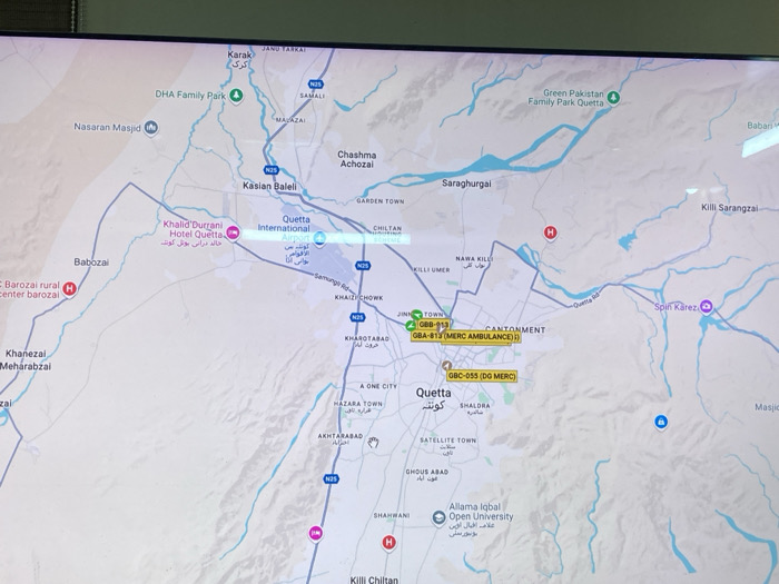
The image displays a digital map of Quetta City Tehsil, Pakistan, presented on a screen. The map details the urban and surrounding rural areas of Quetta. Key geographical features include roadways such as N25 and N50, depicted by purple lines, and numerous light blue lines indicating rivers or water bodies. Elevated terrain or mountainous regions are represented by shaded light brown areas.

Labeled locations include Quetta city, Quetta International Airport, Jinah Town, Kasiar Baleeli, Saraghurai, Hazara Town, Satellite Town, and Akhtarabag. Points of interest are marked with specific icons: Quetta International Airport with an airplane symbol, Khalid Durrani Hotel Quetta with a hotel symbol, DHA Family Park and Green Pakistan Family Park Quetta with tree symbols, Nasaran Masjid with a mosque symbol, and hospitals with red 'H' icons. Allama Iqbal Open University is also labeled.

Two yellow rectangular overlays indicate specific assets:
1.  A marker labeled "GBB-813 GBA-814 (MERC AMBULANCE)" is positioned north of Quetta, near Jinah Town and Cantonment.
2.  A second marker, labeled "GBC-055 (DG MERC)", is located within the central Quetta city area, south of Jinah Town.

Additional map icons visible include a blue circular icon with a white 'i' and a blue circular icon with a white lock symbol. The scene is a photograph of a digital map display.
Aziz Sabawoon

Jul 21, 2025, 10:16 AM

Quetta City Tehsil, Pakistan

Stake attention in this memory

Informative
Neutral
Geographic
Practical
Objective

The image displays a digital map of Quetta City Tehsil, Pakistan, presented on a screen. The map details the urban and surrounding rural areas of Quetta. Key geographical features include roadways such as N25 and N50, depicted by purple lines, and numerous light blue lines indicating rivers or water bodies. Elevated terrain or mountainous regions are represented by shaded light brown areas. Labeled locations include Quetta city, Quetta International Airport, Jinah Town, Kasiar Baleeli, Saraghurai, Hazara Town, Satellite Town, and Akhtarabag. Points of interest are marked with specific icons: Quetta International Airport with an airplane symbol, Khalid Durrani Hotel Quetta with a hotel symbol, DHA Family Park and Green Pakistan Family Park Quetta with tree symbols, Nasaran Masjid with a mosque symbol, and hospitals with red 'H' icons. Allama Iqbal Open University is also labeled. Two yellow rectangular overlays indicate specific assets: 1. A marker labeled "GBB-813 GBA-814 (MERC AMBULANCE)" is positioned north of Quetta, near Jinah Town and Cantonment. 2. A second marker, labeled "GBC-055 (DG MERC)", is located within the central Quetta city area, south of Jinah Town. Additional map icons visible include a blue circular icon with a white 'i' and a blue circular icon with a white lock symbol. The scene is a photograph of a digital map display.

Loading AttnAds…

transactions
revenues
stakers
Earliest
Latest
Highest stake

No transactions found

More from this user

More from Quetta City Tehsil

Aziz Sabawoon

Jul 21, 2025, 10:16 AM

Quetta City Tehsil, Pakistan

Licensed under Creative Commons Attribution 4.0 International License. You are free to share and adapt this content with proper attribution.