Stake attention in this memory
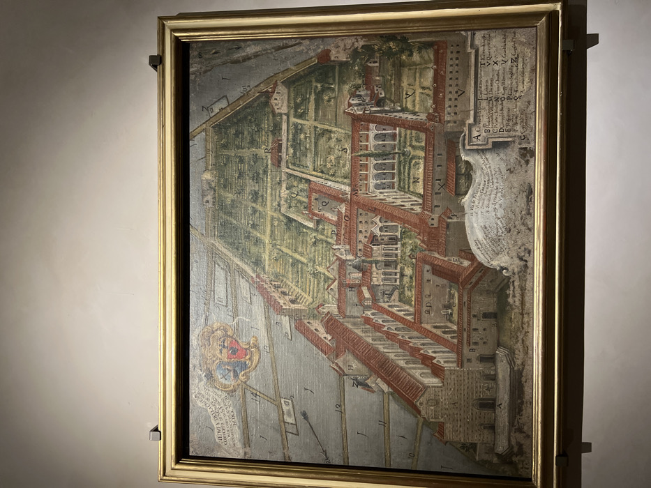
The image displays a framed historical map or painting, likely from the Renaissance or Baroque period, depicting an intricate aerial-perspective plan of an architectural complex and its surrounding gardens. The artwork is housed in a gold-colored, ornate frame and is mounted on a light-colored wall, illuminated by an unseen light source. The map itself is highly detailed, rendered with muted greens for gardens, reddish-browns for building structures and roofs, and various shades of gray and blue for pathways and water bodies. The oblique aerial view provides both a planimetric layout and a sense of architectural volume, revealing courtyards, terraced areas, and formal gardens arranged in geometric patterns. On the right side of the map, a detailed legend is visible, listing letters from A to X. Below these letters, descriptive text in old Italian or Latin identifies various locations or features, including "Villa di Trevi," "Giardino" (garden), "Strada" (street), "Piazza" (square), "Chiesa" (church), "Palazzo" (palace), "Corte" (courtyard), and "Vigna" (vineyard). These labels correspond to letters scattered across the depicted area. In the lower-left corner, a coat of arms is prominently displayed, featuring a crest and an escutcheon. Below the coat of arms, partially visible text includes "CORSINI," suggesting the map depicts a property belonging to the prominent Florentine Corsini family. Numbers like 12, 11, 10, and 9 are also marked along the bottom edge, possibly indicating a scale or coordinate system. The artwork is a static representation, showing no active event or people, but serving as a historical document or artistic rendering of a significant estate or urban area, consistent with its location context in Firenze, Italy.
No transactions found