
Sign in
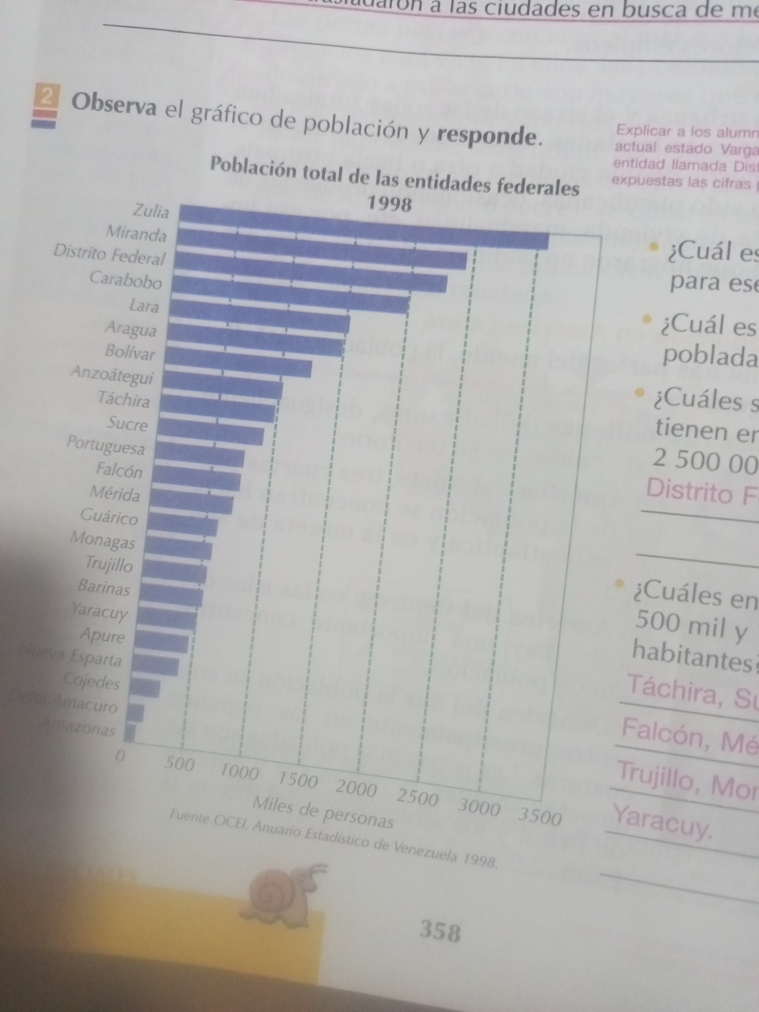
This is an image of a page from a book or educational material, likely in Spanish, as indicated by the text. The main focus is a bar graph displaying "Población total de las entidades federales 1998" (Total population of federal entities 1998). The graph shows various Venezuelan states and the Federal District, ordered by population size from highest to lowest. Zulia is the most populated, followed by Miranda and Distrito Federal. The x-axis is labeled in "Miles de personas" (Thousands of people), ranging from 0 to 3500. The source of the data is cited as "Fuente OCEI. Anuario Estadístico de Venezuela 1998."

To the right of the graph, there are three bulleted questions in Spanish, asking about the most populated entity, the least populated entity, and entities with specific population ranges. The answers to these questions are partially visible, listing names of Venezuelan states like Táchira, Sucre, Falcón, Mérida, Trujillo, Monagas, and Yaracuy.

The page also contains some introductory text above the graph, mentioning "Observa el gráfico de población y responde" (Observe the population graph and answer). There's also a small section of text to the right of the graph's title that seems to be an instruction to the teacher or facilitator, referring to "alumnos" (students) and "actual estado Vargas" (current state of Vargas).

At the bottom of the page, the number "358" is visible, likely a page number. A small illustration of a snail is present on a yellow background in the lower left corner of the image. The overall impression is of an educational resource for students learning about Venezuelan demographics.
Alejandra Jiménez

Jun 17, 2026, 6:14 PM

La Tagua, Venezuela

Moment

Stake attention in this memory

curious
informative
analytical
educational
data-driven

This is an image of a page from a book or educational material, likely in Spanish, as indicated by the text. The main focus is a bar graph displaying "Población total de las entidades federales 1998" (Total population of federal entities 1998). The graph shows various Venezuelan states and the Federal District, ordered by population size from highest to lowest. Zulia is the most populated, followed by Miranda and Distrito Federal. The x-axis is labeled in "Miles de personas" (Thousands of people), ranging from 0 to 3500. The source of the data is cited as "Fuente OCEI. Anuario Estadístico de Venezuela 1998." To the right of the graph, there are three bulleted questions in Spanish, asking about the most populated entity, the least populated entity, and entities with specific population ranges. The answers to these questions are partially visible, listing names of Venezuelan states like Táchira, Sucre, Falcón, Mérida, Trujillo, Monagas, and Yaracuy. The page also contains some introductory text above the graph, mentioning "Observa el gráfico de población y responde" (Observe the population graph and answer). There's also a small section of text to the right of the graph's title that seems to be an instruction to the teacher or facilitator, referring to "alumnos" (students) and "actual estado Vargas" (current state of Vargas). At the bottom of the page, the number "358" is visible, likely a page number. A small illustration of a snail is present on a yellow background in the lower left corner of the image. The overall impression is of an educational resource for students learning about Venezuelan demographics.

Symbol

ADBEB

Volume

11,550

Creator

+$0.03

Revenue

+$0.00

TVL

$2.78

1D
1W
1M
All

Loading AttnAds…

transactions
revenues
stakers
Earliest
Latest
Highest stake

1

cruzaleja

Staked 27d ago

$2.81 USD

-$0.03 USD

-1%

More from this user

More from La Tagua

Alejandra Jiménez

Jun 17, 2026, 6:14 PM

La Tagua, Venezuela

Licensed under Creative Commons Attribution 4.0 International License. You are free to share and adapt this content with proper attribution.